You are here: Home > Network List > XG92 - Rocky Mountain Front Stations List
> Station YUM Yuma, CO > Earthquake Result Viewer
YUM Yuma, CO - Earthquake Result Viewer
| Earthquake location: |
Kuril Islands |
| Earthquake latitude/longitude: |
44.7/149.5 |
| Earthquake time(UTC): |
1992/07/10 (192) 09:31:26 GMT |
| Earthquake Depth: |
11 km |
| Earthquake Magnitude: |
6.1 MB, 6.5 MS |
| Earthquake Catalog/Contributor: |
WHDF/NEIC |
|
| Network: |
XG Rocky Mountain Front |
| Station: |
YUM Yuma, CO |
| Lat/Lon: |
40.16 N/102.78 W |
| Elevation: |
1284 m |
|
| Distance: |
73.5 deg |
| Az: |
49.575 deg |
| Baz: |
314.86 deg |
| Ray Param: |
0.05294615 |
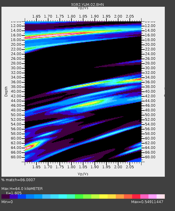
| Estimated Moho Depth: |
64.0 km |
| Estimated Crust Vp/Vs: |
1.61 |
| Assumed Crust Vp: |
6.483 km/s |
| Estimated Crust Vs: |
4.039 km/s |
| Estimated Crust Poisson's Ratio: |
0.18 |
|
| Radial Match: |
86.0807 % |
| Radial Bump: |
400 |
| Transverse Match: |
67.41557 % |
| Transverse Bump: |
400 |
| SOD ConfigId: |
3286 |
| Insert Time: |
2010-02-25 20:12:39.425 +0000 |
| GWidth: |
2.5 |
| Max Bumps: |
400 |
| Tol: |
0.001 |
|
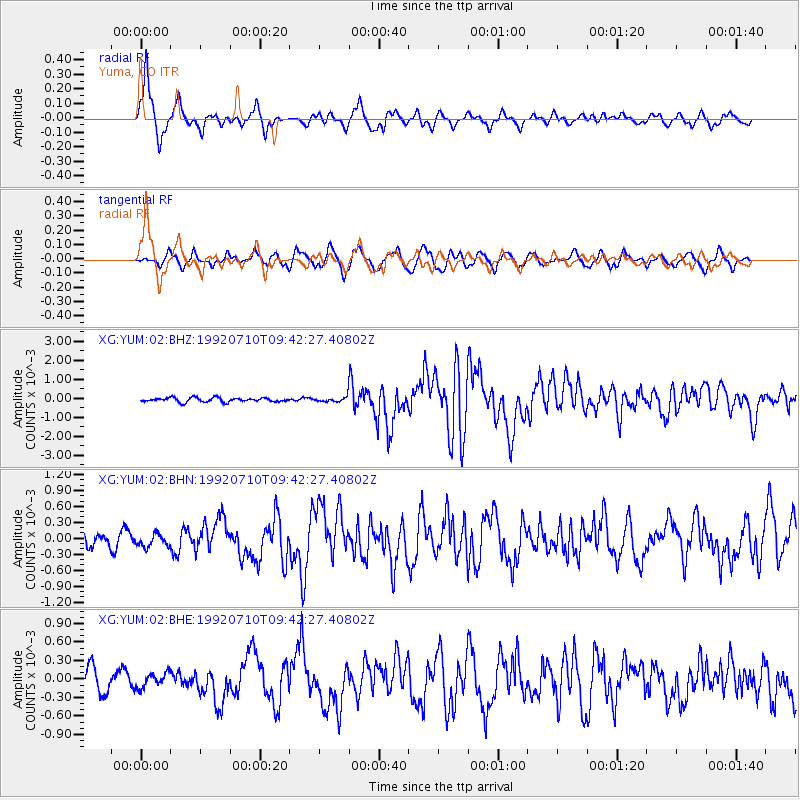
Signal To Noise
| Channel | StoN | STA | LTA |
| XG:YUM:02:BHN:19920710T09:42:27.40802Z | 0.70061237 | 1.1612678E-4 | 1.657504E-4 |
| XG:YUM:02:BHE:19920710T09:42:27.40802Z | 0.5054511 | 1.1464006E-4 | 2.2680743E-4 |
| XG:YUM:02:BHZ:19920710T09:42:27.40802Z | 1.0970018 | 1.22198E-4 | 1.1139271E-4 |
| Arrivals |
| Ps | 6.2 SECOND |
| PpPs | 25 SECOND |
| PsPs/PpSs | 31 SECOND |


