You are here: Home > Network List > XG92 - Rocky Mountain Front Stations List
> Station YUM Yuma, CO > Earthquake Result Viewer
YUM Yuma, CO - Earthquake Result Viewer
| Earthquake location: |
South Of Panama |
| Earthquake latitude/longitude: |
6.1/-82.4 |
| Earthquake time(UTC): |
1992/06/26 (178) 11:32:30 GMT |
| Earthquake Depth: |
33 km |
| Earthquake Magnitude: |
5.8 MB, 5.4 MS |
| Earthquake Catalog/Contributor: |
WHDF/NEIC |
|
| Network: |
XG Rocky Mountain Front |
| Station: |
YUM Yuma, CO |
| Lat/Lon: |
40.16 N/102.78 W |
| Elevation: |
1284 m |
|
| Distance: |
38.5 deg |
| Az: |
334.59 deg |
| Baz: |
146.168 deg |
| Ray Param: |
0.07544578 |
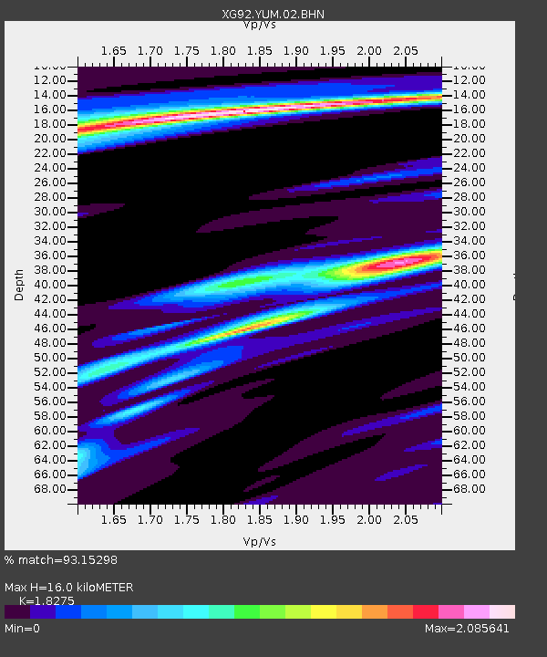
| Estimated Moho Depth: |
16.0 km |
| Estimated Crust Vp/Vs: |
1.83 |
| Assumed Crust Vp: |
6.483 km/s |
| Estimated Crust Vs: |
3.547 km/s |
| Estimated Crust Poisson's Ratio: |
0.29 |
|
| Radial Match: |
93.15298 % |
| Radial Bump: |
215 |
| Transverse Match: |
61.334843 % |
| Transverse Bump: |
300 |
| SOD ConfigId: |
3286 |
| Insert Time: |
2010-02-25 20:12:41.427 +0000 |
| GWidth: |
2.5 |
| Max Bumps: |
400 |
| Tol: |
0.001 |
|
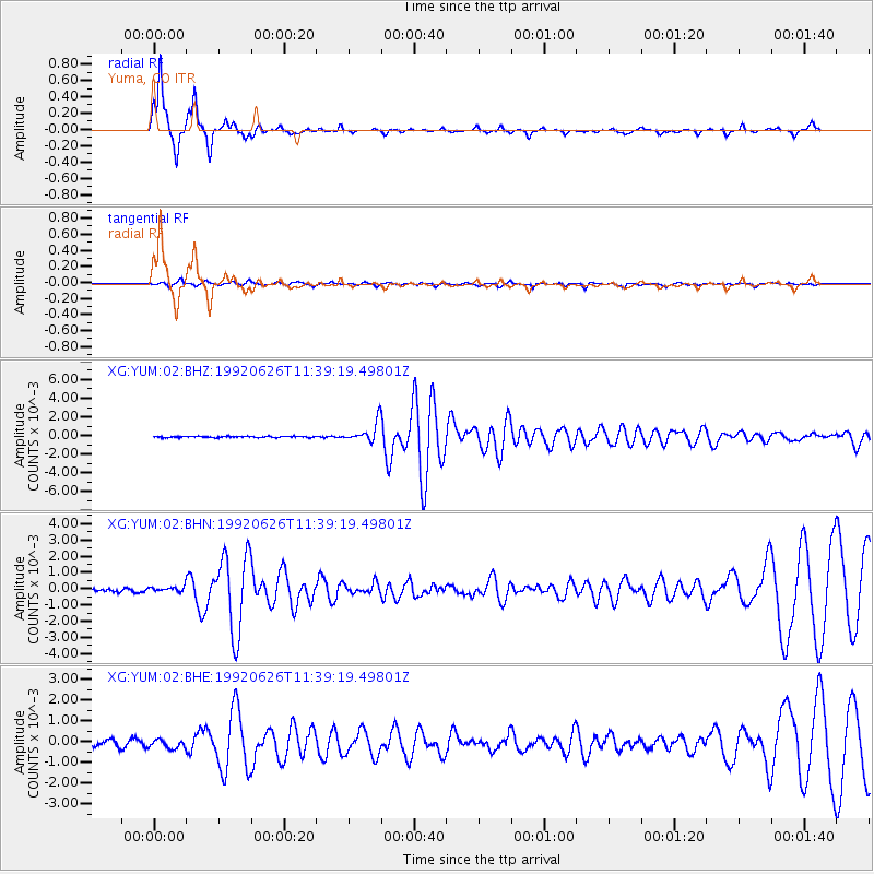
Signal To Noise
| Channel | StoN | STA | LTA |
| XG:YUM:02:BHN:19920626T11:39:19.49801Z | 0.99774414 | 1.5221509E-4 | 1.5255924E-4 |
| XG:YUM:02:BHE:19920626T11:39:19.49801Z | 1.3590665 | 2.0385972E-4 | 1.499998E-4 |
| XG:YUM:02:BHZ:19920626T11:39:19.49801Z | 15.816794 | 0.0010596118 | 6.699283E-5 |
| Arrivals |
| Ps | 2.2 SECOND |
| PpPs | 6.5 SECOND |
| PsPs/PpSs | 8.7 SECOND |


