You are here: Home > Network List > XG92 - Rocky Mountain Front Stations List
> Station YUM Yuma, CO > Earthquake Result Viewer
YUM Yuma, CO - Earthquake Result Viewer
| Earthquake location: |
Hokkaido, Japan Region |
| Earthquake latitude/longitude: |
41.4/142.1 |
| Earthquake time(UTC): |
1992/07/12 (194) 11:08:56 GMT |
| Earthquake Depth: |
70 km |
| Earthquake Magnitude: |
5.9 MB |
| Earthquake Catalog/Contributor: |
WHDF/NEIC |
|
| Network: |
XG Rocky Mountain Front |
| Station: |
YUM Yuma, CO |
| Lat/Lon: |
40.16 N/102.78 W |
| Elevation: |
1284 m |
|
| Distance: |
79.7 deg |
| Az: |
44.823 deg |
| Baz: |
316.247 deg |
| Ray Param: |
0.048629742 |
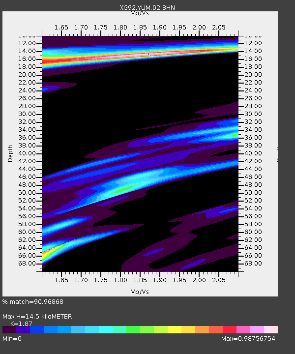
| Estimated Moho Depth: |
14.5 km |
| Estimated Crust Vp/Vs: |
1.87 |
| Assumed Crust Vp: |
6.483 km/s |
| Estimated Crust Vs: |
3.467 km/s |
| Estimated Crust Poisson's Ratio: |
0.30 |
|
| Radial Match: |
90.96868 % |
| Radial Bump: |
369 |
| Transverse Match: |
82.83872 % |
| Transverse Bump: |
400 |
| SOD ConfigId: |
3286 |
| Insert Time: |
2010-02-25 20:12:44.008 +0000 |
| GWidth: |
2.5 |
| Max Bumps: |
400 |
| Tol: |
0.001 |
|
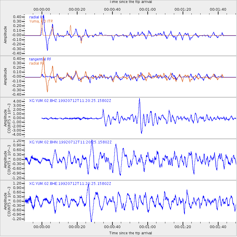
Signal To Noise
| Channel | StoN | STA | LTA |
| XG:YUM:02:BHN:19920712T11:20:25.15802Z | 0.9731225 | 9.207187E-5 | 9.461487E-5 |
| XG:YUM:02:BHE:19920712T11:20:25.15802Z | 1.1828828 | 1.8026526E-4 | 1.5239487E-4 |
| XG:YUM:02:BHZ:19920712T11:20:25.15802Z | 5.3717656 | 4.871681E-4 | 9.069049E-5 |
| Arrivals |
| Ps | 2.0 SECOND |
| PpPs | 6.2 SECOND |
| PsPs/PpSs | 8.2 SECOND |


