You are here: Home > Network List > Z910 - Southeastern Suture of the Appalachian Margin Experiment Stations List
> Station W18 Puryear Farm, Montezuma, GA > Earthquake Result Viewer
W18 Puryear Farm, Montezuma, GA - Earthquake Result Viewer
| Earthquake location: |
Near Coast Of Peru |
| Earthquake latitude/longitude: |
-14.2/-75.6 |
| Earthquake time(UTC): |
2014/02/18 (049) 23:35:58 GMT |
| Earthquake Depth: |
57 km |
| Earthquake Magnitude: |
6.0 MWB, 5.9 MWW, 5.9 MWC, 6.0 MWC |
| Earthquake Catalog/Contributor: |
NEIC PDE/NEIC COMCAT |
|
| Network: |
Z9 Southeastern Suture of the Appalachian Margin Experiment |
| Station: |
W18 Puryear Farm, Montezuma, GA |
| Lat/Lon: |
32.27 N/83.90 W |
| Elevation: |
110 m |
|
| Distance: |
46.8 deg |
| Az: |
350.351 deg |
| Baz: |
168.935 deg |
| Ray Param: |
0.07021919 |
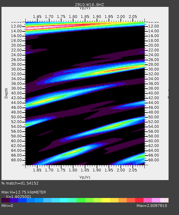
| Estimated Moho Depth: |
12.75 km |
| Estimated Crust Vp/Vs: |
1.60 |
| Assumed Crust Vp: |
6.565 km/s |
| Estimated Crust Vs: |
4.096 km/s |
| Estimated Crust Poisson's Ratio: |
0.18 |
|
| Radial Match: |
81.54152 % |
| Radial Bump: |
357 |
| Transverse Match: |
59.428764 % |
| Transverse Bump: |
331 |
| SOD ConfigId: |
3390531 |
| Insert Time: |
2019-04-10 09:28:11.095 +0000 |
| GWidth: |
2.5 |
| Max Bumps: |
400 |
| Tol: |
0.001 |
|

Signal To Noise
| Channel | StoN | STA | LTA |
| Z9:W18: :BHZ:20140218T23:43:52.079985Z | 5.429394 | 1.2837858E-6 | 2.3645103E-7 |
| Z9:W18: :BHN:20140218T23:43:52.079985Z | 1.9827113 | 1.5504913E-6 | 7.820056E-7 |
| Z9:W18: :BHE:20140218T23:43:52.079985Z | 1.0675833 | 6.874095E-7 | 6.438931E-7 |
| Arrivals |
| Ps | 1.3 SECOND |
| PpPs | 4.7 SECOND |
| PsPs/PpSs | 6.0 SECOND |


