
Station Z9 W18 - Puryear Farm, Montezuma, GA
Network: Z910 - Southeastern Suture of the Appalachian Margin Experiment
Nearby stations (2 deg radius)
| Station | Name | (Lat, Lon) | Start / End | Elevation |
| W18 | Puryear Farm, Montezuma, GA | (32.27, -83.90) | 2010-07-20 / 2014-05-14 | 110 m |
| Crust2 Type: | DG,thin Platform 1 km seds. |
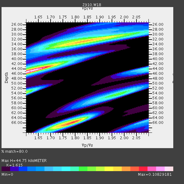
| Thickness Estimate: | 45 km |
| Thickness StdDev: | 9.1 km |
| Vp/Vs Estimate: | 1.62 |
| Vp/Vs StdDev: | 0.08 |
| Vs Estimate: | 4.065 km/s |
| Poisson's Ratio: | 0.19 |
| Peak Value: | 0.11 |
| Assumed Vp: | 6.565 km/s |
| Ps Weight: | 0.33333334 |
| PpPs Weight: | 0.33333334 |
| PsPs Weight: | 0.33333328 |
| Residual Complexity: | 0.879 |
| Nearby stations H: | +- |
| (2.0 deg) Vp/Vs: | +- |
1 with match > 90% ( 2.9411764 %) and 5 with match > 80% ( 14.705882 %) out of 34.
Download stack as xyz text file.
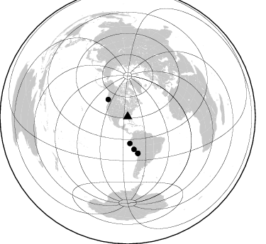
Azimuth Distribution of Events:
Prior Results for this Station
| Study | Thickness | Vp/Vs | Vp | Vs | Poissons Ratio | Extra |
| EARS | 45 km | 1.62 | 6.565 km/s | 4.065 km/s | 0.19 | |
| Crust2.0 | 31 km | 1.78 | 6.565 km/s | 3.684 km/s | 0.27 | DG,thin Platform 1 km seds. |
| Global Maxima | 45 km | 1.62 | 6.565 km/s | 4.065 km/s | 0.19 | amp=0.10829181 |
| Local Maxima 1 | 66 km | 1.79 | 6.565 km/s | 3.672 km/s | 0.27 | amp=0.08732879 |
| Local Maxima 2 | 33 km | 1.83 | 6.565 km/s | 3.597 km/s | 0.29 | amp=0.07519421 |
| Local Maxima 3 | 53 km | 1.60 | 6.565 km/s | 4.103 km/s | 0.18 | amp=0.06415439 |
| Local Maxima 4 | 54 km | 1.99 | 6.565 km/s | 3.295 km/s | 0.33 | amp=0.04833805 |
| Predicted Arrivals for vertical incidence (zero ray parameter) | |
| Ps | 4.19 SECOND |
| PpPs | 17.83 SECOND |
| PsPs/PpSs | 22.02 SECOND |
Events Processed for this Station
Download zip of receiver functions as SAC
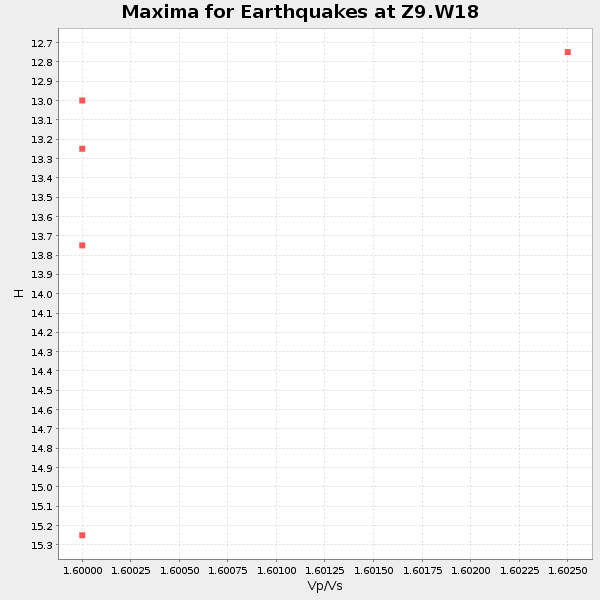
Plot maxima for each earthquake.
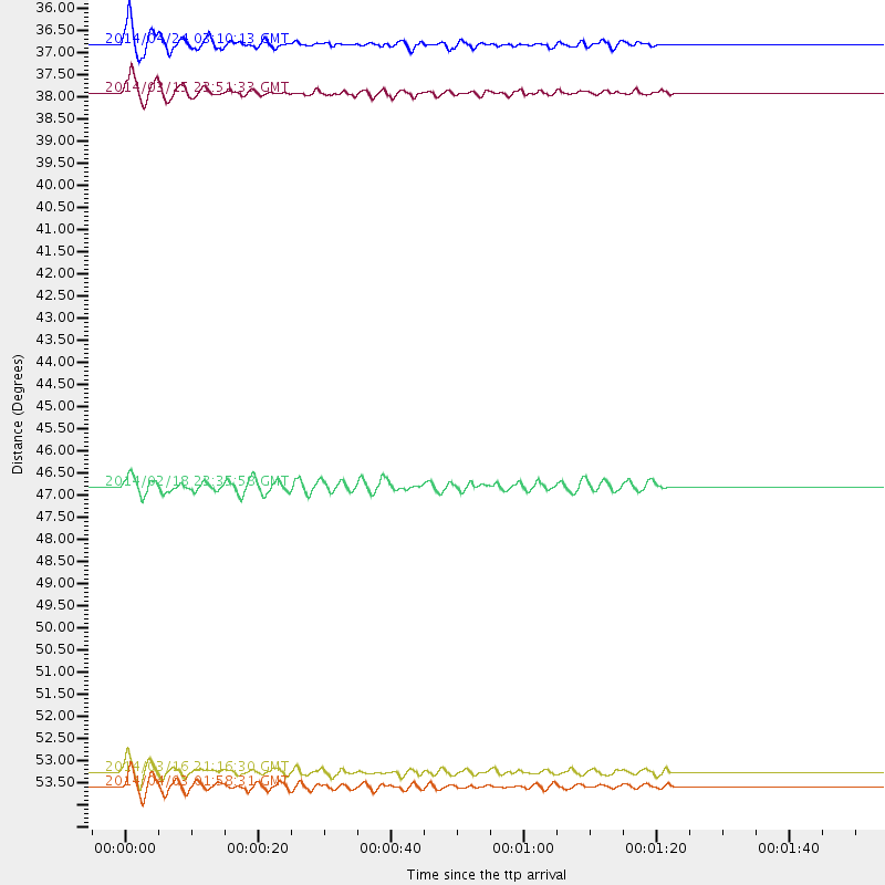
Events Used in the Stack
(5 events)| Radial Match | Distance | Baz | FERegion | Time | Lat/Lon | Depth | Magnitude |
| 90.15385 | 53.4 deg | 164.397 deg | Near Coast Of Northern Chile | 2014/03/16 21:16:30 GMT | (-19.9, -70.6) | 20 km | 6.7 MWW, 6.7 MWC, 7.0 MI |
| 88.1894 | 36.6 deg | 311.632 deg | Vancouver Island, Canada Region | 2014/04/24 03:10:13 GMT | (49.8, -127.4) | 11 km | 6.7 MWP, 6.7 MI |
| 87.11463 | 53.8 deg | 164.418 deg | Near Coast Of Northern Chile | 2014/04/03 01:58:31 GMT | (-20.3, -70.6) | 23 km | 6.5 MWW, 6.5 MWB, 6.6 MWC |
| 86.475975 | 37.7 deg | 175.208 deg | Near Coast Of Northern Peru | 2014/03/15 23:51:33 GMT | (-5.6, -81.0) | 29 km | 6.3 MWW, 6.2 MWB, 6.3 MWC |
| 81.54152 | 46.8 deg | 168.935 deg | Near Coast Of Peru | 2014/02/18 23:35:58 GMT | (-14.2, -75.6) | 57 km | 6.0 MWB, 5.9 MWW, 5.9 MWC, 6.0 MWC |
Losers
(29 events)| Radial Match | Distance | Baz | FERegion | Time | Lat/Lon | Depth | Magnitude | Reason |
| 97.982124 | 53.1 deg | 164.528 deg | Near Coast Of Northern Chile | 2014/04/01 23:46:46 GMT | (-19.6, -70.8) | 20 km | 8.2 MWW, 8.0 MI, 8.1 MWC | |
| 95.223404 | 54.0 deg | 164.428 deg | Near Coast Of Northern Chile | 2014/04/03 02:43:14 GMT | (-20.5, -70.5) | 31 km | 7.7 MWW, 7.4 MI, 7.7 MWC | |
| 89.780334 | 34.0 deg | 296.418 deg | Off Coast Of Northern California | 2014/03/10 05:18:13 GMT | (40.8, -125.1) | 17 km | 6.8 MW, 6.8 MWR, 6.9 MWW, 6.9 MWB, 7.0 MI, 7.0 MWC | |
| 89.66004 | 53.2 deg | 164.629 deg | Near Coast Of Northern Chile | 2014/03/22 12:59:59 GMT | (-19.8, -70.9) | 20 km | 6.2 MWW, 6.2 MWB, 6.3 MWC, 6.4 MWC | |
| 87.37401 | 54.1 deg | 164.73 deg | Near Coast Of Northern Chile | 2014/04/04 01:37:51 GMT | (-20.6, -70.7) | 20 km | 6.1 MWP, 6.1 MWB, 6.1 MWW, 6.3 MWC | |
| 83.481186 | 53.1 deg | 163.739 deg | Near Coast Of Northern Chile | 2014/04/01 23:59:57 GMT | (-19.5, -70.2) | 22 km | 5.8 MB | |
| 75.7944 | 80.6 deg | 50.64 deg | Greece | 2014/02/03 03:08:46 GMT | (38.3, 20.4) | 5.0 km | 6.0 MWW, 6.0 MWB, 6.1 MWC | |
| 72.820274 | 51.9 deg | 323.625 deg | Southern Alaska | 2014/05/10 14:16:08 GMT | (60.0, -152.2) | 96 km | 5.8 ML, 5.5 MI, 5.7 MWP | |
| 71.19237 | 53.2 deg | 164.551 deg | Near Coast Of Northern Chile | 2014/03/23 18:20:03 GMT | (-19.7, -70.8) | 35 km | 6.0 MB, 6.2 MWB, 6.2 MWW, 6.3 MWC | |
| 69.453705 | 54.0 deg | 164.675 deg | Near Coast Of Northern Chile | 2014/04/03 09:23:21 GMT | (-20.6, -70.7) | 15 km | 5.6 MB, 5.3 MWR | |
| 65.49338 | 94.4 deg | 202.999 deg | Southern East Pacific Rise | 2014/02/01 09:17:26 GMT | (-55.1, -126.6) | 10 km | 5.2 MW | |
| 65.25274 | 53.7 deg | 164.594 deg | Near Coast Of Northern Chile | 2014/05/05 11:21:19 GMT | (-20.2, -70.7) | 24 km | 5.4 MW | |
| 64.872215 | 46.7 deg | 169.849 deg | Near Coast Of Peru | 2014/03/15 08:59:21 GMT | (-14.1, -76.3) | 20 km | 6.1 MWW, 6.0 MWB, 6.2 MWC | |
| 64.68135 | 68.7 deg | 317.713 deg | Andreanof Islands, Aleutian Is. | 2014/01/16 07:33:09 GMT | (51.2, -179.2) | 27 km | 5.5 MWB, 5.2 ML, 5.5 ML, 5.6 MWC | |
| 64.353935 | 54.7 deg | 156.697 deg | Southern Bolivia | 2014/01/27 16:42:37 GMT | (-19.3, -63.9) | 600 km | 5.6 MWB | |
| 61.955383 | 57.7 deg | 164.067 deg | Northern Chile | 2014/03/20 18:41:32 GMT | (-24.0, -69.2) | 96 km | 5.1 MW | |
| 60.49095 | 53.7 deg | 164.324 deg | Near Coast Of Northern Chile | 2014/04/05 05:44:57 GMT | (-20.1, -70.5) | 39 km | 5.3 MW | |
| 57.819893 | 98.2 deg | 323.526 deg | Off East Coast Of Honshu, Japan | 2014/01/04 05:23:00 GMT | (37.0, 143.4) | 22 km | 5.5 MWB | |
| 55.56217 | 42.2 deg | 214.033 deg | Central East Pacific Rise | 2014/01/07 23:02:53 GMT | (-4.5, -106.1) | 10 km | 5.7 MWB, 5.8 MWC | |
| 54.40548 | 56.2 deg | 333.18 deg | Northern Alaska | 2014/05/03 08:57:12 GMT | (67.6, -162.2) | 0.9 km | 5.5 MB | |
| 53.280357 | 69.3 deg | 191.023 deg | West Chile Rise | 2014/05/06 20:52:29 GMT | (-36.3, -96.7) | 14 km | 5.9 MWB | |
| 52.639153 | 83.4 deg | 49.955 deg | Southern Greece | 2014/04/04 20:08:07 GMT | (37.2, 23.8) | 107 km | 5.5 MWB, 5.5 MWR, 5.6 MWC, 5.6 MWW | |
| 50.88218 | 54.1 deg | 164.811 deg | Near Coast Of Northern Chile | 2014/01/04 00:11:48 GMT | (-20.7, -70.8) | 26 km | 5.7 MWW, 5.8 MWB, 5.8 MWC | |
| 49.25294 | 69.9 deg | 194.845 deg | Southeast Of Easter Island | 2014/04/15 13:31:33 GMT | (-36.1, -101.2) | 14 km | 5.6 MW | |
| 47.677204 | 53.9 deg | 164.481 deg | Near Coast Of Northern Chile | 2014/04/02 19:45:49 GMT | (-20.4, -70.6) | 17 km | 5.3 MW | |
| 44.10349 | 86.3 deg | 332.961 deg | Sakhalin, Russia | 2014/02/19 12:49:06 GMT | (52.2, 143.5) | 17 km | 4.9 MW | |
| 43.98929 | 53.3 deg | 164.609 deg | Near Coast Of Northern Chile | 2014/03/23 20:23:04 GMT | (-19.9, -70.8) | 23 km | 5.3 MW | |
| 43.671066 | 63.6 deg | 318.315 deg | Fox Islands, Aleutian Islands | 2014/02/26 21:13:40 GMT | (53.6, -171.8) | 265 km | 6.1 MWW, 5.9 MI, 5.9 ML, 6.1 MWC, 6.1 MWB, 6.2 MWC | |
| 41.281322 | 53.5 deg | 164.514 deg | Near Coast Of Northern Chile | 2014/03/17 00:12:11 GMT | (-20.0, -70.7) | 19 km | 5.1 mb |

