You are here: Home > Network List > IC - New China Digital Seismograph Network Stations List
> Station HIA Hailar, Neimenggu Autonomous Region, China > Earthquake Result Viewer
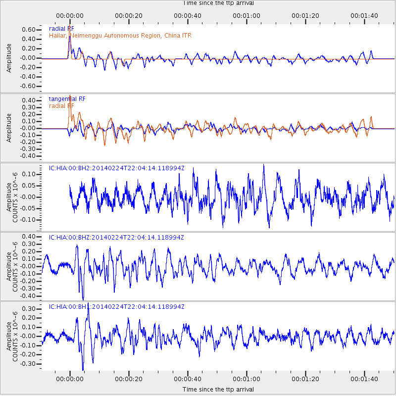
HIA Hailar, Neimenggu Autonomous Region, China - Earthquake Result Viewer
*The percent match for this event was below the threshold and hence no stack was calculated.
| Earthquake location: |
Northern Molucca Sea |
| Earthquake latitude/longitude: |
0.6/126.1 |
| Earthquake time(UTC): |
2014/02/24 (055) 21:56:04 GMT |
| Earthquake Depth: |
52 km |
| Earthquake Magnitude: |
5.4 MW |
| Earthquake Catalog/Contributor: |
ISC/ISC |
|
| Network: |
IC New China Digital Seismograph Network |
| Station: |
HIA Hailar, Neimenggu Autonomous Region, China |
| Lat/Lon: |
49.27 N/119.74 E |
| Elevation: |
620 m |
|
| Distance: |
48.8 deg |
| Az: |
354.433 deg |
| Baz: |
171.484 deg |
| Ray Param: |
$rayparam |
*The percent match for this event was below the threshold and hence was not used in the summary stack. |
|
| Radial Match: |
65.04498 % |
| Radial Bump: |
400 |
| Transverse Match: |
60.150566 % |
| Transverse Bump: |
400 |
| SOD ConfigId: |
3390531 |
| Insert Time: |
2019-04-10 10:35:37.427 +0000 |
| GWidth: |
2.5 |
| Max Bumps: |
400 |
| Tol: |
0.001 |
|
Signal To Noise
| Channel | StoN | STA | LTA |
| IC:HIA:00:BHZ:20140224T22:04:14.118994Z | 2.5562878 | 1.8492172E-7 | 7.233995E-8 |
| IC:HIA:00:BH1:20140224T22:04:14.118994Z | 2.877037 | 1.3578473E-7 | 4.719603E-8 |
| IC:HIA:00:BH2:20140224T22:04:14.118994Z | 1.0382012 | 3.5665202E-8 | 3.4352883E-8 |
| Arrivals |
| Ps | |
| PpPs | |
| PsPs/PpSs | |


