You are here: Home > Network List > TA - USArray Transportable Network (new EarthScope stations) Stations List
> Station W41A Tony Mavity, Velonia, AR, USA > Earthquake Result Viewer
W41A Tony Mavity, Velonia, AR, USA - Earthquake Result Viewer
| Earthquake location: |
Eastern Honshu, Japan |
| Earthquake latitude/longitude: |
37.0/140.4 |
| Earthquake time(UTC): |
2011/04/11 (101) 08:16:12 GMT |
| Earthquake Depth: |
11 km |
| Earthquake Magnitude: |
6.4 MB, 6.5 MS, 6.6 MW, 6.6 MW |
| Earthquake Catalog/Contributor: |
WHDF/NEIC |
|
| Network: |
TA USArray Transportable Network (new EarthScope stations) |
| Station: |
W41A Tony Mavity, Velonia, AR, USA |
| Lat/Lon: |
35.17 N/92.25 W |
| Elevation: |
95 m |
|
| Distance: |
93.1 deg |
| Az: |
40.707 deg |
| Baz: |
320.407 deg |
| Ray Param: |
0.041325226 |
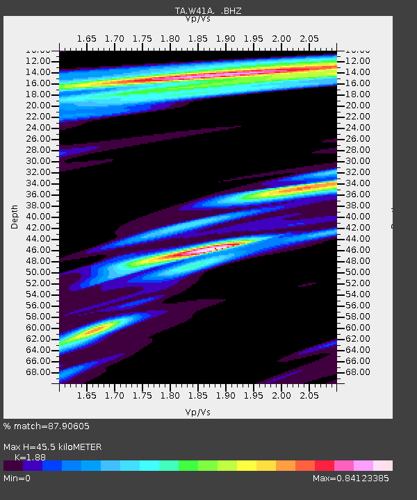
| Estimated Moho Depth: |
45.5 km |
| Estimated Crust Vp/Vs: |
1.88 |
| Assumed Crust Vp: |
6.498 km/s |
| Estimated Crust Vs: |
3.456 km/s |
| Estimated Crust Poisson's Ratio: |
0.30 |
|
| Radial Match: |
87.90605 % |
| Radial Bump: |
400 |
| Transverse Match: |
65.98355 % |
| Transverse Bump: |
400 |
| SOD ConfigId: |
356183 |
| Insert Time: |
2011-09-27 07:19:11.642 +0000 |
| GWidth: |
2.5 |
| Max Bumps: |
400 |
| Tol: |
0.001 |
|

Signal To Noise
| Channel | StoN | STA | LTA |
| TA:W41A: :BHZ:20110411T08:28:54.925007Z | 9.681372 | 1.294916E-6 | 1.3375336E-7 |
| TA:W41A: :BHN:20110411T08:28:54.925007Z | 2.194603 | 2.5409454E-7 | 1.15781546E-7 |
| TA:W41A: :BHE:20110411T08:28:54.925007Z | 2.3958948 | 2.1018532E-7 | 8.772727E-8 |
| Arrivals |
| Ps | 6.3 SECOND |
| PpPs | 20 SECOND |
| PsPs/PpSs | 26 SECOND |


