
Station TA W41A - Tony Mavity, Velonia, AR, USA
Network: TA - USArray Transportable Network (new EarthScope stations)
Nearby stations (2 deg radius)
| Station | Name | (Lat, Lon) | Start / End | Elevation |
| W41A | Tony Mavity, Velonia, AR, USA | (35.17, -92.25) | 2011-04-06 / 2011-08-06 | 95 m |
| Crust2 Type: | D9,Platform 1 km seds. |
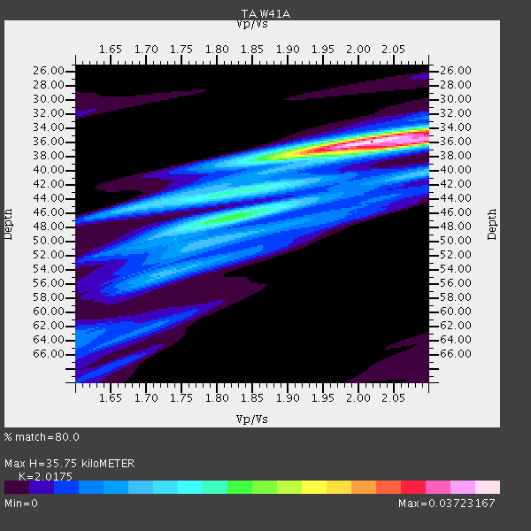
| Thickness Estimate: | 36 km |
| Thickness StdDev: | 2.3 km |
| Vp/Vs Estimate: | 2.02 |
| Vp/Vs StdDev: | 0.06 |
| Vs Estimate: | 3.221 km/s |
| Poisson's Ratio: | 0.34 |
| Peak Value: | 0.04 |
| Assumed Vp: | 6.498 km/s |
| Ps Weight: | 0.33333334 |
| PpPs Weight: | 0.33333334 |
| PsPs Weight: | 0.33333328 |
| Residual Complexity: | 0.612 |
| Nearby stations H: | 36 km +- 0.0 km |
| (2.0 deg) Vp/Vs: | 2.01 +- 0.00 |
5 with match > 90% ( 20.0 %) and 10 with match > 80% ( 40.0 %) out of 25.
Download stack as xyz text file.
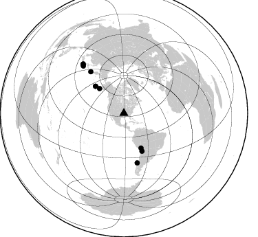
Azimuth Distribution of Events:
Prior Results for this Station
| Study | Thickness | Vp/Vs | Vp | Vs | Poissons Ratio | Extra |
| EARS | 36 km | 2.02 | 6.498 km/s | 3.221 km/s | 0.34 | |
| Crust2.0 | 41 km | 1.77 | 6.498 km/s | 3.666 km/s | 0.27 | D9,Platform 1 km seds. |
| Global Maxima | 36 km | 2.02 | 6.498 km/s | 3.221 km/s | 0.34 | amp=0.03723167 |
| Local Maxima 1 | 36 km | 2.10 | 6.498 km/s | 3.101 km/s | 0.35 | amp=0.02223434 |
| Local Maxima 2 | 47 km | 1.79 | 6.498 km/s | 3.625 km/s | 0.27 | amp=0.014855162 |
| Local Maxima 3 | 44 km | 1.78 | 6.498 km/s | 3.645 km/s | 0.27 | amp=0.012664789 |
| Local Maxima 4 | 40 km | 2.09 | 6.498 km/s | 3.109 km/s | 0.35 | amp=0.009944649 |
| Predicted Arrivals for vertical incidence (zero ray parameter) | |
| Ps | 5.60 SECOND |
| PpPs | 16.60 SECOND |
| PsPs/PpSs | 22.20 SECOND |
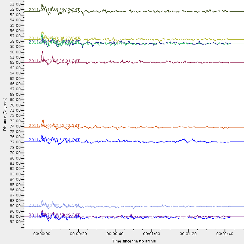
Events Processed for this Station
Download zip of receiver functions as SAC
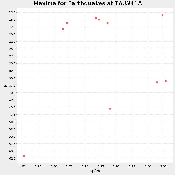
Plot maxima for each earthquake.
Events Used in the Stack
(10 events)| Radial Match | Distance | Baz | FERegion | Time | Lat/Lon | Depth | Magnitude |
| 97.525505 | 61.0 deg | 154.349 deg | Chile-Bolivia Border Region | 2011/06/20 16:36:01 GMT | (-21.7, -68.2) | 128 km | 6.0 MB, 6.5 MW, 6.5 MW |
| 97.38135 | 57.1 deg | 313.697 deg | Fox Islands, Aleutian Islands | 2011/06/24 03:09:39 GMT | (52.0, -171.8) | 52 km | 6.9 MB, 7.3 MW, 7.3 MW |
| 96.48481 | 90.8 deg | 319.388 deg | Off East Coast Of Honshu, Japan | 2011/07/10 00:57:10 GMT | (38.0, 143.3) | 23 km | 6.6 MB, 7.0 MS, 7.0 MW, 7.0 MW |
| 93.64392 | 74.4 deg | 164.781 deg | Near Coast Of Central Chile | 2011/06/01 12:55:22 GMT | (-37.6, -73.7) | 21 km | 5.6 MB, 6.2 MS, 6.3 MW, 6.3 MW |
| 93.249016 | 92.9 deg | 320.031 deg | Near East Coast Of Honshu, Japan | 2011/07/30 18:53:49 GMT | (36.9, 141.0) | 30 km | 6.4 MB, 6.0 MS, 6.5 MW, 6.4 MW |
| 87.90605 | 93.1 deg | 320.407 deg | Eastern Honshu, Japan | 2011/04/11 08:16:12 GMT | (37.0, 140.4) | 11 km | 6.4 MB, 6.5 MS, 6.6 MW, 6.6 MW |
| 85.61683 | 50.4 deg | 315.427 deg | Alaska Peninsula | 2011/07/16 19:59:12 GMT | (54.8, -161.3) | 36 km | 6.3 MB, 5.9 MS, 6.2 MW, 6.1 MW |
| 84.570015 | 57.1 deg | 313.711 deg | Fox Islands, Aleutian Islands | 2011/06/28 06:48:32 GMT | (52.1, -171.7) | 30 km | 5.6 MB, 5.4 MS, 5.9 MW, 5.6 MW |
| 82.32061 | 77.3 deg | 321.431 deg | Kuril Islands | 2011/08/04 13:51:34 GMT | (48.8, 154.8) | 36 km | 6.0 MB, 5.8 MS, 6.1 MW, 6.0 MW |
| 81.05011 | 56.3 deg | 153.619 deg | Peru-Bolivia Border Region | 2011/06/08 03:06:22 GMT | (-17.1, -69.5) | 146 km | 5.8 MB, 5.9 MW, 5.9 MW |
Losers
(15 events)| Radial Match | Distance | Baz | FERegion | Time | Lat/Lon | Depth | Magnitude | Reason |
| 76.27602 | 90.3 deg | 319.035 deg | Off East Coast Of Honshu, Japan | 2011/05/05 14:58:18 GMT | (38.2, 144.0) | 11 km | 6.2 MB, 5.7 MS, 6.1 MW, 6.1 MW | |
| 75.87198 | 62.8 deg | 315.094 deg | Rat Islands, Aleutian Islands | 2011/07/18 22:38:38 GMT | (51.3, 178.9) | 19 km | 5.8 MW, 5.3 MS, 5.4 MB, 5.8 MW | |
| 73.49064 | 92.0 deg | 320.285 deg | Near East Coast Of Honshu, Japan | 2011/07/24 18:51:24 GMT | (37.7, 141.4) | 35 km | 6.3 MB, 5.9 MS, 6.3 MW, 6.3 MW | |
| 72.28479 | 71.2 deg | 162.14 deg | Near Coast Of Central Chile | 2011/07/16 00:26:12 GMT | (-33.8, -71.8) | 20 km | 5.8 MB, 5.8 MS, 6.1 MW, 6.0 MW | |
| 71.3999 | 88.3 deg | 41.631 deg | Turkey | 2011/05/19 20:15:22 GMT | (39.1, 29.1) | 7.0 km | 5.8 MB, 5.8 MS, 5.9 MW, 5.8 MW | |
| 68.45231 | 90.9 deg | 320.811 deg | Near East Coast Of Honshu, Japan | 2011/07/23 04:34:24 GMT | (38.9, 141.8) | 41 km | 5.9 MB, 5.9 MS, 6.4 MW, 6.3 MW | |
| 65.21566 | 68.2 deg | 152.348 deg | Santiago Del Estero Prov., Arg. | 2011/04/17 01:58:49 GMT | (-27.6, -63.2) | 557 km | 5.6 MB, 5.9 MW, 5.8 MW | |
| 64.272575 | 94.2 deg | 319.265 deg | Near East Coast Of Honshu, Japan | 2011/04/11 23:08:16 GMT | (35.4, 140.6) | 15 km | 6.0 MB, 6.1 MS, 6.2 MW, 6.2 MW | |
| 58.51481 | 89.0 deg | 320.784 deg | Off East Coast Of Honshu, Japan | 2011/04/21 00:39:03 GMT | (40.3, 143.5) | 10 km | 5.7 MW, 5.2 MS, 5.4 MB, 5.6 MW | |
| 57.168015 | 90.3 deg | 320.332 deg | Near East Coast Of Honshu, Japan | 2011/04/23 10:12:46 GMT | (39.1, 142.9) | 31 km | 5.8 MB, 5.6 MS, 6.0 MW, 5.9 MW | |
| 56.307655 | 91.9 deg | 320.083 deg | Near East Coast Of Honshu, Japan | 2011/06/18 11:31:05 GMT | (37.7, 141.7) | 20 km | 5.9 MB, 5.4 MS, 5.8 MW, 5.6 MW | |
| 53.94658 | 95.9 deg | 320.104 deg | Near S. Coast Of Honshu, Japan | 2011/08/01 14:58:09 GMT | (34.6, 138.4) | 13 km | 6.0 MB, 5.6 MS, 5.9 MW, 5.9 MW | |
| 51.703186 | 70.7 deg | 103.46 deg | Central Mid-Atlantic Ridge | 2011/05/15 13:08:13 GMT | (0.6, -25.6) | 10 km | 5.6 MB, 5.4 MS, 6.1 MW, 6.1 MW | |
| 50.29001 | 92.1 deg | 319.951 deg | Near East Coast Of Honshu, Japan | 2011/04/28 09:27:47 GMT | (37.5, 141.7) | 38 km | 5.8 MB, 5.1 MS, 5.6 MW, 5.5 MW | |
| 21.733591 | 50.5 deg | 106.431 deg | Northern Mid-Atlantic Ridge | 2011/07/27 23:00:30 GMT | (10.8, -43.4) | 10 km | 5.6 MB, 5.6 MS, 6.0 MW, 5.9 MW |
