You are here: Home > Network List > AZ - ANZA Regional Network Stations List
> Station SMER2 AZ.SMER2 > Earthquake Result Viewer
SMER2 AZ.SMER2 - Earthquake Result Viewer
| Earthquake location: |
Western Brazil |
| Earthquake latitude/longitude: |
-8.3/-71.7 |
| Earthquake time(UTC): |
2002/10/12 (285) 20:09:11 GMT |
| Earthquake Depth: |
534 km |
| Earthquake Magnitude: |
6.5 MB, 6.9 MW, 6.9 MW |
| Earthquake Catalog/Contributor: |
WHDF/NEIC |
|
| Network: |
AZ ANZA Regional Network |
| Station: |
SMER2 AZ.SMER2 |
| Lat/Lon: |
33.46 N/117.17 W |
| Elevation: |
355 m |
|
| Distance: |
59.9 deg |
| Az: |
316.479 deg |
| Baz: |
125.392 deg |
| Ray Param: |
0.05982306 |
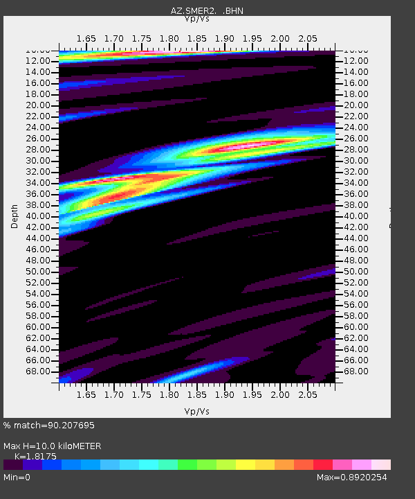
| Estimated Moho Depth: |
10.0 km |
| Estimated Crust Vp/Vs: |
1.82 |
| Assumed Crust Vp: |
6.264 km/s |
| Estimated Crust Vs: |
3.446 km/s |
| Estimated Crust Poisson's Ratio: |
0.28 |
|
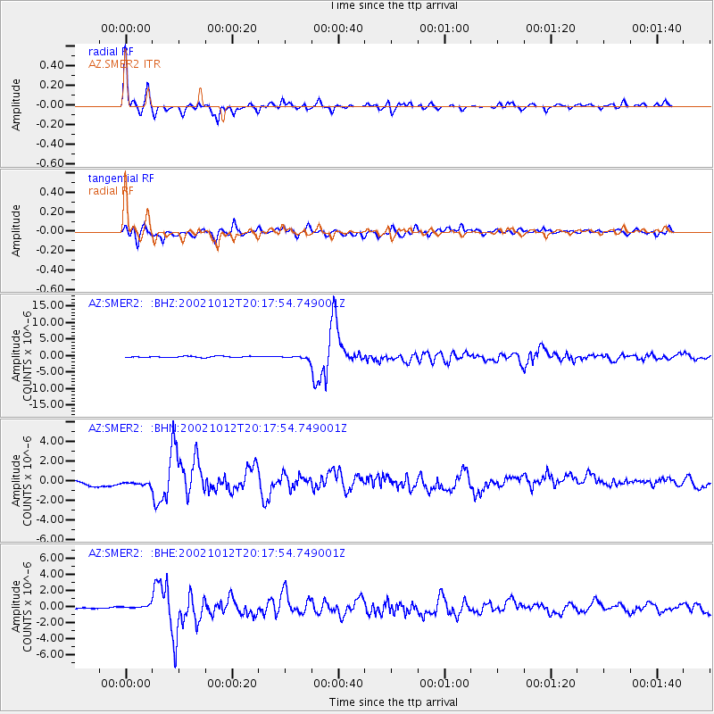
| Radial Match: |
90.207695 % |
| Radial Bump: |
359 |
| Transverse Match: |
75.52846 % |
| Transverse Bump: |
400 |
| SOD ConfigId: |
4714 |
| Insert Time: |
2010-02-26 20:49:40.307 +0000 |
| GWidth: |
2.5 |
| Max Bumps: |
400 |
| Tol: |
0.001 |
|
Signal To Noise
| Channel | StoN | STA | LTA |
| AZ:SMER2: :BHN:20021012T20:17:54.749001Z | 0.27309272 | 1.3855365E-7 | 5.073502E-7 |
| AZ:SMER2: :BHE:20021012T20:17:54.749001Z | 1.4443637 | 2.2679112E-7 | 1.5701801E-7 |
| AZ:SMER2: :BHZ:20021012T20:17:54.749001Z | 2.9255052 | 5.302815E-7 | 1.8126151E-7 |
| Arrivals |
| Ps | 1.4 SECOND |
| PpPs | 4.3 SECOND |
| PsPs/PpSs | 5.7 SECOND |


