You are here: Home > Network List > TA - USArray Transportable Network (new EarthScope stations) Stations List
> Station W41A Tony Mavity, Velonia, AR, USA > Earthquake Result Viewer
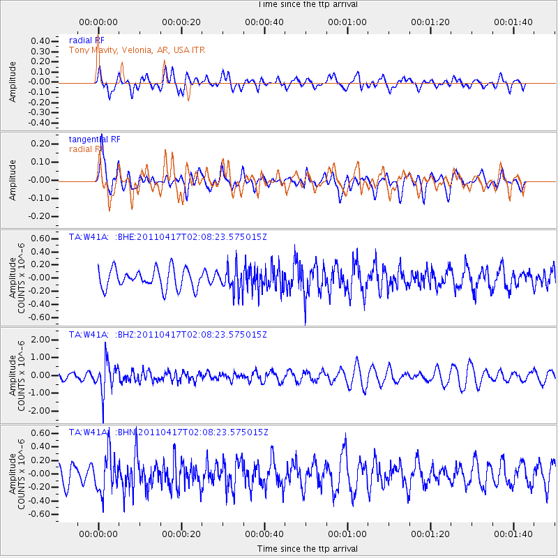
W41A Tony Mavity, Velonia, AR, USA - Earthquake Result Viewer
*The percent match for this event was below the threshold and hence no stack was calculated.
| Earthquake location: |
Santiago Del Estero Prov., Arg. |
| Earthquake latitude/longitude: |
-27.6/-63.2 |
| Earthquake time(UTC): |
2011/04/17 (107) 01:58:49 GMT |
| Earthquake Depth: |
557 km |
| Earthquake Magnitude: |
5.6 MB, 5.9 MW, 5.8 MW |
| Earthquake Catalog/Contributor: |
WHDF/NEIC |
|
| Network: |
TA USArray Transportable Network (new EarthScope stations) |
| Station: |
W41A Tony Mavity, Velonia, AR, USA |
| Lat/Lon: |
35.17 N/92.25 W |
| Elevation: |
95 m |
|
| Distance: |
68.2 deg |
| Az: |
334.635 deg |
| Baz: |
152.348 deg |
| Ray Param: |
$rayparam |
*The percent match for this event was below the threshold and hence was not used in the summary stack. |
|
| Radial Match: |
65.21566 % |
| Radial Bump: |
400 |
| Transverse Match: |
72.5341 % |
| Transverse Bump: |
400 |
| SOD ConfigId: |
356183 |
| Insert Time: |
2011-09-30 12:12:33.145 +0000 |
| GWidth: |
2.5 |
| Max Bumps: |
400 |
| Tol: |
0.001 |
|
Signal To Noise
| Channel | StoN | STA | LTA |
| TA:W41A: :BHZ:20110417T02:08:23.575015Z | 3.428717 | 8.3420025E-7 | 2.4329808E-7 |
| TA:W41A: :BHN:20110417T02:08:23.575015Z | 1.858122 | 2.8220887E-7 | 1.5187855E-7 |
| TA:W41A: :BHE:20110417T02:08:23.575015Z | 1.1958312 | 1.7636145E-7 | 1.4748024E-7 |
| Arrivals |
| Ps | |
| PpPs | |
| PsPs/PpSs | |


