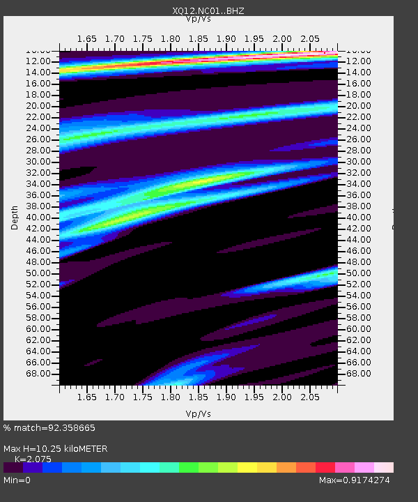
NC01 NC01 - Earthquake Result Viewer

Earthquake location: Near Coast Of Northern Peru
Earthquake latitude/longitude: -5.6/-81.0
Earthquake time(UTC): 2014/03/15 (074) 23:51:33 GMT
Earthquake Depth: 29 km
Earthquake Magnitude: 6.3 MWW, 6.2 MWB, 6.3 MWC
Earthquake Catalog/Contributor: NEIC PDE/NEIC COMCAT
Network: XQ Pre-Hydrofracking Regional Assessment of Central Carolina Seismicity
Station: NC01 NC01
Lat/Lon: 35.62 N/79.20 W
Elevation: 107 m
Distance: 41.0 deg
Az: 2.18 deg
Baz: 182.663 deg
Ray Param: 0.07400127
Estimated Moho Depth: 10.25 km
Estimated Crust Vp/Vs: 2.08
Assumed Crust Vp: 6.565 km/s
Estimated Crust Vs: 3.164 km/s
Estimated Crust Poisson's Ratio: 0.35
Radial Match: 92.358665 %
Radial Bump: 280
Transverse Match: 72.642746 %
Transverse Bump: 400
SOD ConfigId: 3390531
Insert Time: 2019-04-10 16:45:09.697 +0000
GWidth: 2.5
Max Bumps: 400
Tol: 0.001

Signal To Noise

ChannelStoNSTALTA
XQ:NC01: :BHZ:20140315T23:58:43.214988Z5.6344959.56282E-71.697192E-7
XQ:NC01: :BHN:20140315T23:58:43.214988Z4.4520334.6257577E-71.0390214E-7
XQ:NC01: :BHE:20140315T23:58:43.214988Z1.21927371.2445841E-71.0207586E-7
Arrivals
Ps1.8 SECOND
PpPs4.5 SECOND
PsPs/PpSs6.3 SECOND