
Station XQ NC01 - NC01
Network: XQ12 - Pre-Hydrofracking Regional Assessment of Central Carolina Seismicity
Nearby stations (2 deg radius)
| Station | Name | (Lat, Lon) | Start / End | Elevation |
| NC01 | NC01 | (35.62, -79.20) | 2012-03-26 / 2014-12-31 | 107 m |
| Crust2 Type: | DG,thin Platform 1 km seds. |
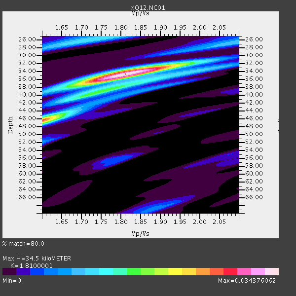
| Thickness Estimate: | 34 km |
| Thickness StdDev: | 3.8 km |
| Vp/Vs Estimate: | 1.81 |
| Vp/Vs StdDev: | 0.07 |
| Vs Estimate: | 3.627 km/s |
| Poisson's Ratio: | 0.28 |
| Peak Value: | 0.03 |
| Assumed Vp: | 6.565 km/s |
| Ps Weight: | 0.33333334 |
| PpPs Weight: | 0.33333334 |
| PsPs Weight: | 0.33333328 |
| Residual Complexity: | 0.533 |
| Nearby stations H: | +- |
| (2.0 deg) Vp/Vs: | +- |
6 with match > 90% ( 18.75 %) and 8 with match > 80% ( 25.0 %) out of 32.
Download stack as xyz text file.
Azimuth Distribution of Events:

Prior Results for this Station
| Study | Thickness | Vp/Vs | Vp | Vs | Poissons Ratio | Extra |
| EARS | 34 km | 1.81 | 6.565 km/s | 3.627 km/s | 0.28 | |
| Crust2.0 | 31 km | 1.78 | 6.565 km/s | 3.684 km/s | 0.27 | DG,thin Platform 1 km seds. |
| Global Maxima | 34 km | 1.81 | 6.565 km/s | 3.627 km/s | 0.28 | amp=0.034376062 |
| Local Maxima 1 | 46 km | 1.60 | 6.565 km/s | 4.103 km/s | 0.18 | amp=0.02566661 |
| Local Maxima 2 | 26 km | 1.75 | 6.565 km/s | 3.762 km/s | 0.26 | amp=0.011515423 |
| Local Maxima 3 | 36 km | 1.88 | 6.565 km/s | 3.496 km/s | 0.30 | amp=0.011393877 |
| Local Maxima 4 | 33 km | 1.83 | 6.565 km/s | 3.582 km/s | 0.29 | amp=0.010603356 |
| Predicted Arrivals for vertical incidence (zero ray parameter) | |
| Ps | 4.26 SECOND |
| PpPs | 14.77 SECOND |
| PsPs/PpSs | 19.03 SECOND |
Events Processed for this Station
Download zip of receiver functions as SAC
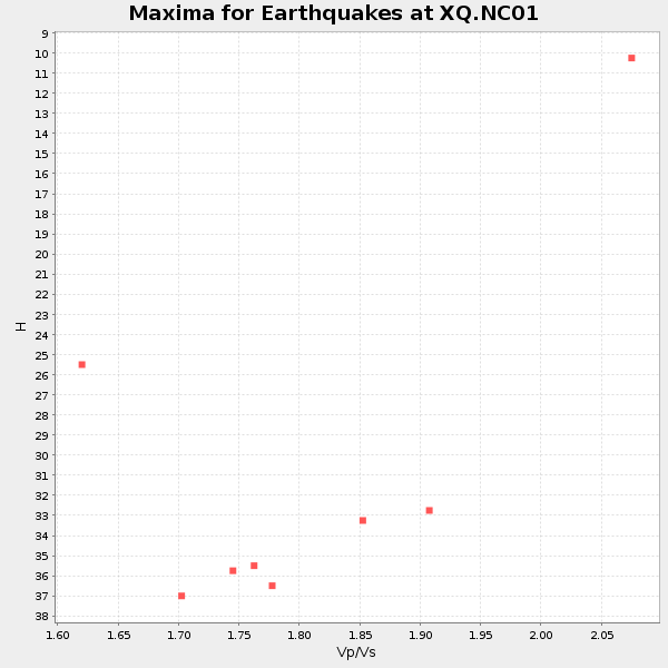
Plot maxima for each earthquake.
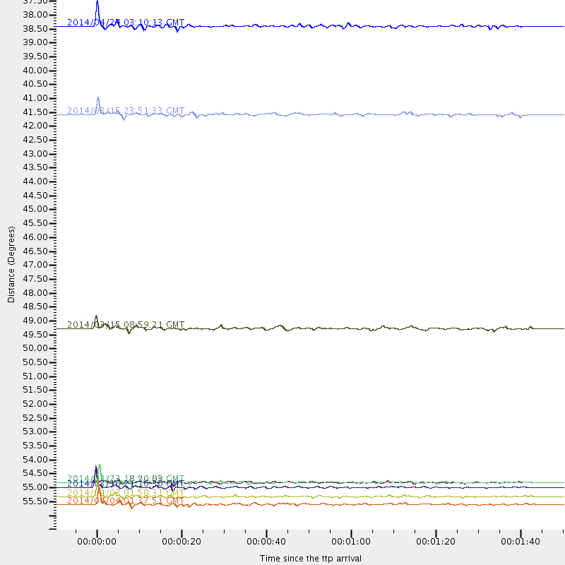
Events Used in the Stack
(8 events)| Radial Match | Distance | Baz | FERegion | Time | Lat/Lon | Depth | Magnitude |
| 97.933266 | 55.8 deg | 170.241 deg | Near Coast Of Northern Chile | 2014/03/16 21:16:30 GMT | (-19.9, -70.6) | 20 km | 6.7 MWW, 6.7 MWC, 7.0 MI |
| 96.49364 | 56.2 deg | 170.221 deg | Near Coast Of Northern Chile | 2014/04/03 01:58:31 GMT | (-20.3, -70.6) | 23 km | 6.5 MWW, 6.5 MWB, 6.6 MWC |
| 96.234955 | 55.6 deg | 170.49 deg | Near Coast Of Northern Chile | 2014/03/22 12:59:59 GMT | (-19.8, -70.9) | 20 km | 6.2 MWW, 6.2 MWB, 6.3 MWC, 6.4 MWC |
| 94.06104 | 56.5 deg | 170.487 deg | Near Coast Of Northern Chile | 2014/04/04 01:37:51 GMT | (-20.6, -70.7) | 20 km | 6.1 MWP, 6.1 MWB, 6.1 MWW, 6.3 MWC |
| 93.83989 | 37.5 deg | 307.534 deg | Vancouver Island, Canada Region | 2014/04/24 03:10:13 GMT | (49.8, -127.4) | 11 km | 6.7 MWP, 6.7 MI |
| 92.358665 | 41.0 deg | 182.663 deg | Near Coast Of Northern Peru | 2014/03/15 23:51:33 GMT | (-5.6, -81.0) | 29 km | 6.3 MWW, 6.2 MWB, 6.3 MWC |
| 89.153946 | 55.6 deg | 170.415 deg | Near Coast Of Northern Chile | 2014/03/23 18:20:03 GMT | (-19.7, -70.8) | 35 km | 6.0 MB, 6.2 MWB, 6.2 MWW, 6.3 MWC |
| 80.705284 | 49.5 deg | 176.31 deg | Near Coast Of Peru | 2014/03/15 08:59:21 GMT | (-14.1, -76.3) | 20 km | 6.1 MWW, 6.0 MWB, 6.2 MWC |
Losers
(24 events)| Radial Match | Distance | Baz | FERegion | Time | Lat/Lon | Depth | Magnitude | Reason |
| 99.197975 | 55.5 deg | 170.405 deg | Near Coast Of Northern Chile | 2014/04/01 23:46:46 GMT | (-19.6, -70.8) | 20 km | 8.2 MWW, 8.0 MI, 8.1 MWC | |
| 98.845505 | 56.4 deg | 170.2 deg | Near Coast Of Northern Chile | 2014/04/03 02:43:14 GMT | (-20.5, -70.5) | 31 km | 7.7 MWW, 7.4 MI, 7.7 MWC | |
| 95.40154 | 36.1 deg | 292.387 deg | Off Coast Of Northern California | 2014/03/10 05:18:13 GMT | (40.8, -125.1) | 17 km | 6.8 MW, 6.8 MWR, 6.9 MWW, 6.9 MWB, 7.0 MI, 7.0 MWC | |
| 83.32077 | 56.5 deg | 170.726 deg | Near Coast Of Northern Chile | 2014/04/11 08:39:43 GMT | (-20.6, -71.0) | 13 km | 4.9 mb | |
| 80.01275 | 75.5 deg | 53.302 deg | Greece | 2014/02/03 03:08:46 GMT | (38.3, 20.4) | 5.0 km | 6.0 MWW, 6.0 MWB, 6.1 MWC | |
| 74.85745 | 55.9 deg | 170.531 deg | Near Coast Of Northern Chile | 2014/03/17 05:11:34 GMT | (-20.0, -70.9) | 17 km | 6.2 MWW, 6.2 MWB, 6.5 MWC | |
| 73.80977 | 49.6 deg | 175.416 deg | Near Coast Of Peru | 2014/02/18 23:35:58 GMT | (-14.2, -75.6) | 57 km | 6.0 MWB, 5.9 MWW, 5.9 MWC, 6.0 MWC | |
| 70.20958 | 56.0 deg | 170.55 deg | Near Coast Of Northern Chile | 2014/04/07 13:43:20 GMT | (-20.2, -70.9) | 7.9 km | 5.8 MWB, 5.7 MWW, 5.7 MWC | |
| 69.51359 | 56.5 deg | 170.486 deg | Near Coast Of Northern Chile | 2014/04/13 12:11:30 GMT | (-20.6, -70.7) | 13 km | 5.5 MWW, 5.3 MWR | |
| 68.04238 | 55.5 deg | 170.398 deg | Near Coast Of Northern Chile | 2014/03/24 15:45:31 GMT | (-19.6, -70.8) | 18 km | 5.6 MWB, 5.5 MWR, 5.7 MWC, 5.7 MWW | |
| 66.88094 | 33.7 deg | 274.313 deg | Off W. Coast Of Baja California | 2014/03/05 02:24:23 GMT | (31.3, -119.5) | 9.0 km | 4.9 MW | |
| 62.79637 | 64.9 deg | 354.738 deg | East Of Severnaya Zemlya | 2014/01/14 03:43:05 GMT | (78.8, 126.0) | 10 km | 4.1 mb | |
| 62.180367 | 55.7 deg | 170.378 deg | Near Coast Of Northern Chile | 2014/03/24 11:26:39 GMT | (-19.8, -70.8) | 22 km | 5.7 MWW, 5.7 MWB, 5.8 MWC | |
| 59.236763 | 90.6 deg | 202.173 deg | Southern East Pacific Rise | 2014/04/09 08:28:48 GMT | (-49.7, -114.7) | 10 km | 5.6 Mwc | |
| 58.135 | 81.5 deg | 330.319 deg | Northwest Of Kuril Islands | 2014/03/12 18:18:40 GMT | (52.0, 153.2) | 418 km | 5.1 MW | |
| 56.16622 | 55.5 deg | 169.641 deg | Near Coast Of Northern Chile | 2014/04/01 23:59:57 GMT | (-19.5, -70.2) | 22 km | 5.8 MB | |
| 55.485382 | 51.5 deg | 173.765 deg | Near Coast Of Peru | 2014/02/02 08:57:09 GMT | (-15.9, -74.1) | 45 km | 5.2 MW | |
| 52.955444 | 55.1 deg | 332.478 deg | Northern Alaska | 2014/04/18 18:56:47 GMT | (67.7, -162.5) | 17 km | 5.7 MW | |
| 52.837013 | 63.7 deg | 318.38 deg | Fox Islands, Aleutian Islands | 2014/02/26 21:13:40 GMT | (53.6, -171.8) | 265 km | 6.1 MWW, 5.9 MI, 5.9 ML, 6.1 MWC, 6.1 MWB, 6.2 MWC | |
| 51.09304 | 81.1 deg | 178.155 deg | Off Coast Of Southern Chile | 2014/03/02 16:18:30 GMT | (-45.9, -76.6) | 23 km | 5.0 MW | |
| 49.526814 | 56.5 deg | 162.62 deg | Southern Bolivia | 2014/01/27 16:42:37 GMT | (-19.3, -63.9) | 600 km | 5.6 MWB | |
| 46.685543 | 56.4 deg | 170.44 deg | Near Coast Of Northern Chile | 2014/04/03 09:23:21 GMT | (-20.6, -70.7) | 15 km | 5.6 MB, 5.3 MWR | |
| 42.581272 | 68.8 deg | 318.329 deg | Andreanof Islands, Aleutian Is. | 2014/01/16 07:33:09 GMT | (51.2, -179.2) | 27 km | 5.5 MWB, 5.2 ML, 5.5 ML, 5.6 MWC | |
| 41.719997 | 55.8 deg | 170.495 deg | Near Coast Of Northern Chile | 2014/03/17 11:12:17 GMT | (-19.9, -70.9) | 26 km | 5.0 MW |

