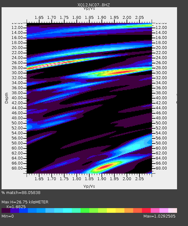
NC07 NC07 - Earthquake Result Viewer

Earthquake location: Near Coast Of Northern Peru
Earthquake latitude/longitude: -5.6/-81.0
Earthquake time(UTC): 2014/03/15 (074) 23:51:33 GMT
Earthquake Depth: 29 km
Earthquake Magnitude: 6.3 MWW, 6.2 MWB, 6.3 MWC
Earthquake Catalog/Contributor: NEIC PDE/NEIC COMCAT
Network: XQ Pre-Hydrofracking Regional Assessment of Central Carolina Seismicity
Station: NC07 NC07
Lat/Lon: 35.47 N/79.38 W
Elevation: 99 m
Distance: 40.9 deg
Az: 1.967 deg
Baz: 182.399 deg
Ray Param: 0.07409852
Estimated Moho Depth: 26.75 km
Estimated Crust Vp/Vs: 1.68
Assumed Crust Vp: 6.565 km/s
Estimated Crust Vs: 3.902 km/s
Estimated Crust Poisson's Ratio: 0.23
Radial Match: 88.05838 %
Radial Bump: 307
Transverse Match: 63.007233 %
Transverse Bump: 400
SOD ConfigId: 3390531
Insert Time: 2019-04-10 16:45:11.757 +0000
GWidth: 2.5
Max Bumps: 400
Tol: 0.001

Signal To Noise

ChannelStoNSTALTA
XQ:NC07: :BHZ:20140315T23:58:41.92501Z4.5856237.485658E-71.6324192E-7
XQ:NC07: :BHN:20140315T23:58:41.92501Z3.36803585.5160564E-71.6377665E-7
XQ:NC07: :BHE:20140315T23:58:41.92501Z0.76876951.275954E-71.6597355E-7
Arrivals
Ps3.0 SECOND
PpPs10 SECOND
PsPs/PpSs13 SECOND