
Station XQ NC07 - NC07
Network: XQ12 - Pre-Hydrofracking Regional Assessment of Central Carolina Seismicity
Nearby stations (2 deg radius)
| Station | Name | (Lat, Lon) | Start / End | Elevation |
| NC07 | NC07 | (35.47, -79.38) | 2012-03-25 / 2014-12-31 | 99 m |
| Crust2 Type: | DG,thin Platform 1 km seds. |
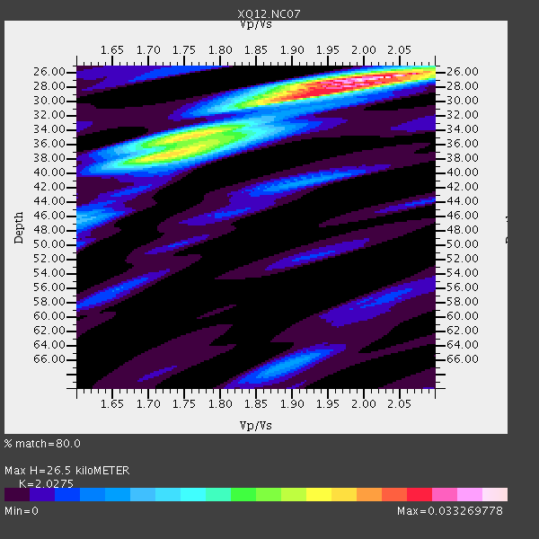
| Thickness Estimate: | 26 km |
| Thickness StdDev: | 3.4 km |
| Vp/Vs Estimate: | 2.03 |
| Vp/Vs StdDev: | 0.09 |
| Vs Estimate: | 3.238 km/s |
| Poisson's Ratio: | 0.34 |
| Peak Value: | 0.03 |
| Assumed Vp: | 6.565 km/s |
| Ps Weight: | 0.33333334 |
| PpPs Weight: | 0.33333334 |
| PsPs Weight: | 0.33333328 |
| Residual Complexity: | 0.643 |
| Nearby stations H: | +- |
| (2.0 deg) Vp/Vs: | +- |
5 with match > 90% ( 13.888889 %) and 7 with match > 80% ( 19.444445 %) out of 36.
Download stack as xyz text file.
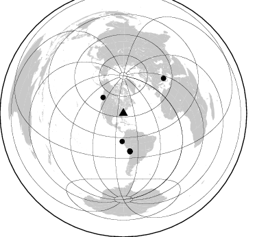
Azimuth Distribution of Events:
Prior Results for this Station
| Study | Thickness | Vp/Vs | Vp | Vs | Poissons Ratio | Extra |
| EARS | 26 km | 2.03 | 6.565 km/s | 3.238 km/s | 0.34 | |
| Crust2.0 | 31 km | 1.78 | 6.565 km/s | 3.684 km/s | 0.27 | DG,thin Platform 1 km seds. |
| Global Maxima | 26 km | 2.03 | 6.565 km/s | 3.238 km/s | 0.34 | amp=0.033269778 |
| Local Maxima 1 | 37 km | 1.73 | 6.565 km/s | 3.8 km/s | 0.25 | amp=0.021699768 |
| Local Maxima 2 | 29 km | 1.91 | 6.565 km/s | 3.437 km/s | 0.31 | amp=0.019846847 |
| Local Maxima 3 | 35 km | 1.73 | 6.565 km/s | 3.8 km/s | 0.25 | amp=0.011756691 |
| Local Maxima 4 | 41 km | 1.92 | 6.565 km/s | 3.423 km/s | 0.31 | amp=0.008193788 |
| Predicted Arrivals for vertical incidence (zero ray parameter) | |
| Ps | 4.15 SECOND |
| PpPs | 12.22 SECOND |
| PsPs/PpSs | 16.37 SECOND |
Events Processed for this Station
Download zip of receiver functions as SAC
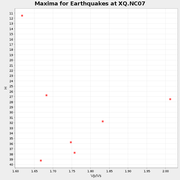
Plot maxima for each earthquake.
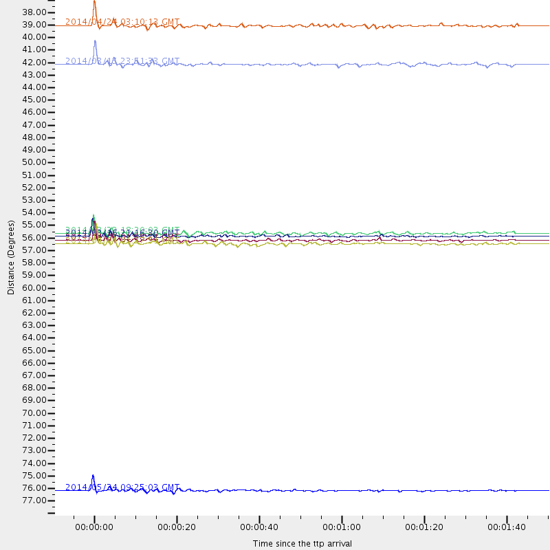
Events Used in the Stack
(7 events)| Radial Match | Distance | Baz | FERegion | Time | Lat/Lon | Depth | Magnitude |
| 96.55245 | 55.7 deg | 170.022 deg | Near Coast Of Northern Chile | 2014/03/16 21:16:30 GMT | (-19.9, -70.6) | 20 km | 6.7 MWW, 6.7 MWC, 7.0 MI |
| 95.28265 | 77.7 deg | 49.153 deg | Aegean Sea | 2014/05/24 09:25:03 GMT | (40.3, 25.5) | 10 km | 6.4 MWP, 6.4 M |
| 94.97611 | 56.4 deg | 170.271 deg | Near Coast Of Northern Chile | 2014/04/04 01:37:51 GMT | (-20.6, -70.7) | 20 km | 6.1 MWP, 6.1 MWB, 6.1 MWW, 6.3 MWC |
| 94.644615 | 56.1 deg | 170.003 deg | Near Coast Of Northern Chile | 2014/04/03 01:58:31 GMT | (-20.3, -70.6) | 23 km | 6.5 MWW, 6.5 MWB, 6.6 MWC |
| 92.91628 | 37.5 deg | 307.703 deg | Vancouver Island, Canada Region | 2014/04/24 03:10:13 GMT | (49.8, -127.4) | 11 km | 6.7 MWP, 6.7 MI |
| 89.82373 | 55.5 deg | 170.196 deg | Near Coast Of Northern Chile | 2014/03/23 18:20:03 GMT | (-19.7, -70.8) | 35 km | 6.0 MB, 6.2 MWB, 6.2 MWW, 6.3 MWC |
| 88.05838 | 40.9 deg | 182.399 deg | Near Coast Of Northern Peru | 2014/03/15 23:51:33 GMT | (-5.6, -81.0) | 29 km | 6.3 MWW, 6.2 MWB, 6.3 MWC |
Losers
(29 events)| Radial Match | Distance | Baz | FERegion | Time | Lat/Lon | Depth | Magnitude | Reason |
| 98.542305 | 56.3 deg | 169.984 deg | Near Coast Of Northern Chile | 2014/04/03 02:43:14 GMT | (-20.5, -70.5) | 31 km | 7.7 MWW, 7.4 MI, 7.7 MWC | |
| 98.29648 | 55.4 deg | 170.185 deg | Near Coast Of Northern Chile | 2014/04/01 23:46:46 GMT | (-19.6, -70.8) | 20 km | 8.2 MWW, 8.0 MI, 8.1 MWC | |
| 94.1763 | 36.1 deg | 292.552 deg | Off Coast Of Northern California | 2014/03/10 05:18:13 GMT | (40.8, -125.1) | 17 km | 6.8 MW, 6.8 MWR, 6.9 MWW, 6.9 MWB, 7.0 MI, 7.0 MWC | |
| 85.97975 | 56.4 deg | 170.511 deg | Near Coast Of Northern Chile | 2014/04/11 08:39:43 GMT | (-20.6, -71.0) | 13 km | 4.9 mb | |
| 81.96812 | 51.6 deg | 322.252 deg | Southern Alaska | 2014/05/10 14:16:08 GMT | (60.0, -152.2) | 96 km | 5.8 ML, 5.5 MI, 5.7 MWP | |
| 78.6957 | 46.9 deg | 217.732 deg | Central East Pacific Rise | 2014/05/18 23:47:04 GMT | (-4.5, -106.0) | 17 km | 5.9 MW | |
| 78.06149 | 49.4 deg | 176.073 deg | Near Coast Of Peru | 2014/03/15 08:59:21 GMT | (-14.1, -76.3) | 20 km | 6.1 MWW, 6.0 MWB, 6.2 MWC | |
| 76.73674 | 55.8 deg | 170.382 deg | Near Coast Of Northern Chile | 2014/03/18 21:33:05 GMT | (-20.0, -70.9) | 6.3 km | 5.1 mb | |
| 74.49133 | 49.5 deg | 175.178 deg | Near Coast Of Peru | 2014/02/18 23:35:58 GMT | (-14.2, -75.6) | 57 km | 6.0 MWB, 5.9 MWW, 5.9 MWC, 6.0 MWC | |
| 72.187744 | 55.9 deg | 170.332 deg | Near Coast Of Northern Chile | 2014/04/07 13:43:20 GMT | (-20.2, -70.9) | 7.9 km | 5.8 MWB, 5.7 MWW, 5.7 MWC | |
| 65.53678 | 84.0 deg | 327.264 deg | Kuril Islands | 2014/01/10 18:03:00 GMT | (48.2, 154.1) | 82 km | 5.1 MW | |
| 63.75923 | 63.7 deg | 318.38 deg | Fox Islands, Aleutian Islands | 2014/02/26 21:13:40 GMT | (53.6, -171.8) | 265 km | 6.1 MWW, 5.9 MI, 5.9 ML, 6.1 MWC, 6.1 MWB, 6.2 MWC | |
| 61.85892 | 55.2 deg | 332.469 deg | Northern Alaska | 2014/04/18 18:44:17 GMT | (67.7, -162.5) | 1.0 km | 5.5 MB, 5.4 MI | |
| 61.244976 | 90.6 deg | 201.906 deg | Southern East Pacific Rise | 2014/05/12 18:38:37 GMT | (-50.0, -114.7) | 8.2 km | 5.8 MB | |
| 61.185204 | 31.6 deg | 278.46 deg | Southern California | 2014/03/29 04:09:43 GMT | (33.9, -117.9) | 14 km | 5.1 MW | |
| 60.773094 | 47.0 deg | 216.956 deg | Central East Pacific Rise | 2014/05/19 01:53:54 GMT | (-4.8, -105.5) | 10 km | 5.5 MWB, 5.6 MWC | |
| 60.749767 | 88.0 deg | 352.558 deg | East Of Lake Baykal, Russia | 2014/05/23 19:42:28 GMT | (56.1, 114.0) | 10 km | 5.6 MB | |
| 59.23067 | 55.8 deg | 170.347 deg | Near Coast Of Northern Chile | 2014/05/17 09:11:06 GMT | (-20.0, -70.9) | 13 km | 5.5 MB | |
| 59.172497 | 56.9 deg | 169.218 deg | Northern Chile | 2014/01/07 03:43:23 GMT | (-21.0, -69.7) | 87 km | 5.4 MW | |
| 54.750088 | 55.2 deg | 332.514 deg | Northern Alaska | 2014/04/18 18:56:47 GMT | (67.7, -162.5) | 17 km | 5.7 MW | |
| 54.579998 | 42.9 deg | 180.121 deg | Near Coast Of Northern Peru | 2014/05/15 22:43:17 GMT | (-7.7, -79.5) | 62 km | 5.0 MW | |
| 54.091507 | 74.0 deg | 198.235 deg | Southeast Of Easter Island | 2014/04/15 13:31:33 GMT | (-36.1, -101.2) | 14 km | 5.6 MW | |
| 51.20126 | 33.6 deg | 274.453 deg | Off W. Coast Of Baja California | 2014/03/05 02:24:23 GMT | (31.3, -119.5) | 9.0 km | 4.9 MW | |
| 49.453682 | 55.4 deg | 169.42 deg | Near Coast Of Northern Chile | 2014/04/01 23:59:57 GMT | (-19.5, -70.2) | 22 km | 5.8 MB | |
| 47.37129 | 55.4 deg | 170.177 deg | Near Coast Of Northern Chile | 2014/03/24 15:45:31 GMT | (-19.6, -70.8) | 18 km | 5.6 MWB, 5.5 MWR, 5.7 MWC, 5.7 MWW | |
| 46.22448 | 73.2 deg | 194.541 deg | West Chile Rise | 2014/05/06 20:52:29 GMT | (-36.3, -96.7) | 14 km | 5.9 MWB | |
| 41.51149 | 80.9 deg | 177.734 deg | Off Coast Of Southern Chile | 2014/03/02 17:03:43 GMT | (-45.8, -76.2) | 10 km | 5.4 MW | |
| 41.272274 | 38.0 deg | 297.658 deg | Off Coast Of Oregon | 2014/05/12 18:51:00 GMT | (43.7, -128.1) | 14 km | 5.5 MW | |
| 39.733673 | 68.8 deg | 318.307 deg | Andreanof Islands, Aleutian Is. | 2014/01/16 07:33:09 GMT | (51.2, -179.2) | 27 km | 5.5 MWB, 5.2 ML, 5.5 ML, 5.6 MWC |

