You are here: Home > Network List > Z910 - Southeastern Suture of the Appalachian Margin Experiment Stations List
> Station D12 Alewine Property, Royston, GA > Earthquake Result Viewer
D12 Alewine Property, Royston, GA - Earthquake Result Viewer
| Earthquake location: |
Near Coast Of Northern Peru |
| Earthquake latitude/longitude: |
-5.6/-81.0 |
| Earthquake time(UTC): |
2014/03/15 (074) 23:51:33 GMT |
| Earthquake Depth: |
29 km |
| Earthquake Magnitude: |
6.3 MWW, 6.2 MWB, 6.3 MWC |
| Earthquake Catalog/Contributor: |
NEIC PDE/NEIC COMCAT |
|
| Network: |
Z9 Southeastern Suture of the Appalachian Margin Experiment |
| Station: |
D12 Alewine Property, Royston, GA |
| Lat/Lon: |
34.25 N/83.03 W |
| Elevation: |
247 m |
|
| Distance: |
39.7 deg |
| Az: |
357.304 deg |
| Baz: |
176.76 deg |
| Ray Param: |
0.074805 |
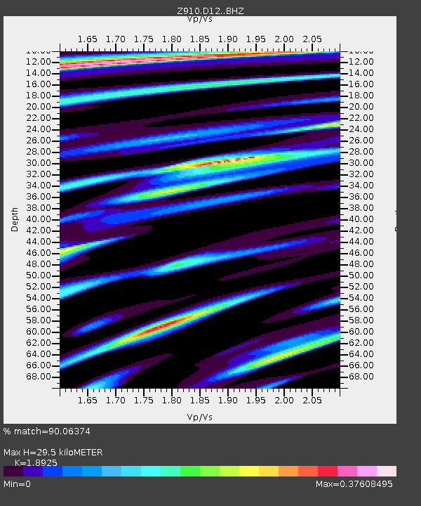
| Estimated Moho Depth: |
29.5 km |
| Estimated Crust Vp/Vs: |
1.89 |
| Assumed Crust Vp: |
6.35 km/s |
| Estimated Crust Vs: |
3.355 km/s |
| Estimated Crust Poisson's Ratio: |
0.31 |
|
| Radial Match: |
90.06374 % |
| Radial Bump: |
270 |
| Transverse Match: |
56.08006 % |
| Transverse Bump: |
400 |
| SOD ConfigId: |
3390531 |
| Insert Time: |
2019-04-10 16:46:39.430 +0000 |
| GWidth: |
2.5 |
| Max Bumps: |
400 |
| Tol: |
0.001 |
|

Signal To Noise
| Channel | StoN | STA | LTA |
| Z9:D12: :BHZ:20140315T23:58:32.020011Z | 6.634144 | 6.8013367E-7 | 1.0252019E-7 |
| Z9:D12: :BHN:20140315T23:58:32.020011Z | 4.0053935 | 4.0703335E-7 | 1.0162131E-7 |
| Z9:D12: :BHE:20140315T23:58:32.020011Z | 1.0927496 | 1.3364654E-7 | 1.2230299E-7 |
| Arrivals |
| Ps | 4.4 SECOND |
| PpPs | 13 SECOND |
| PsPs/PpSs | 17 SECOND |


