
Station Z9 D12 - Alewine Property, Royston, GA
Network: Z910 - Southeastern Suture of the Appalachian Margin Experiment
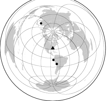
Nearby stations (2 deg radius)
| Station | Name | (Lat, Lon) | Start / End | Elevation |
| D12 | Alewine Property, Royston, GA | (34.25, -83.03) | 2012-05-03 / 2014-05-20 | 247 m |
| Crust2 Type: | P6,orogen/43km, Orogen, 0.5 km seds. |
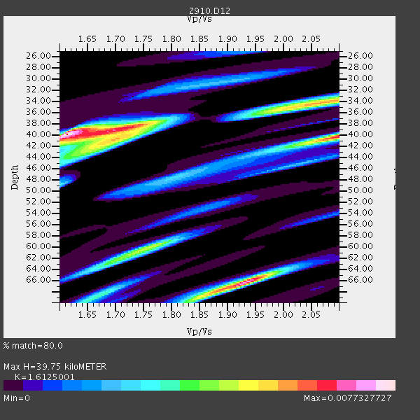
| Thickness Estimate: | 40 km |
| Thickness StdDev: | 12 km |
| Vp/Vs Estimate: | 1.61 |
| Vp/Vs StdDev: | 0.12 |
| Vs Estimate: | 3.938 km/s |
| Poisson's Ratio: | 0.19 |
| Peak Value: | 0.01 |
| Assumed Vp: | 6.35 km/s |
| Ps Weight: | 0.33333334 |
| PpPs Weight: | 0.33333334 |
| PsPs Weight: | 0.33333328 |
| Residual Complexity: | 0.806 |
| Nearby stations H: | +- |
| (2.0 deg) Vp/Vs: | +- |
3 with match > 90% ( 7.5 %) and 5 with match > 80% ( 12.5 %) out of 40.
Download stack as xyz text file.
Azimuth Distribution of Events:
Prior Results for this Station
| Study | Thickness | Vp/Vs | Vp | Vs | Poissons Ratio | Extra |
| EARS | 40 km | 1.61 | 6.35 km/s | 3.938 km/s | 0.19 | |
| Crust2.0 | 43 km | 1.76 | 6.35 km/s | 3.609 km/s | 0.26 | P6,orogen/43km, Orogen, 0.5 km seds. |
| Global Maxima | 40 km | 1.61 | 6.35 km/s | 3.938 km/s | 0.19 | amp=0.0077327727 |
| Local Maxima 1 | 66 km | 1.93 | 6.35 km/s | 3.29 km/s | 0.32 | amp=0.0071205553 |
| Local Maxima 2 | 40 km | 2.09 | 6.35 km/s | 3.035 km/s | 0.35 | amp=0.0064357026 |
| Local Maxima 3 | 40 km | 1.70 | 6.35 km/s | 3.73 km/s | 0.24 | amp=0.005281628 |
| Local Maxima 4 | 60 km | 1.76 | 6.35 km/s | 3.598 km/s | 0.26 | amp=0.0043814816 |
| Predicted Arrivals for vertical incidence (zero ray parameter) | |
| Ps | 3.83 SECOND |
| PpPs | 16.35 SECOND |
| PsPs/PpSs | 20.19 SECOND |
Events Processed for this Station
Download zip of receiver functions as SAC
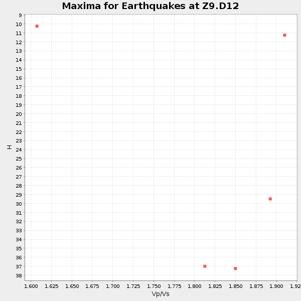
Plot maxima for each earthquake.
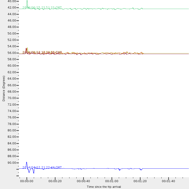
Events Used in the Stack
(5 events)| Radial Match | Distance | Baz | FERegion | Time | Lat/Lon | Depth | Magnitude |
| 95.655464 | 55.1 deg | 165.741 deg | Near Coast Of Northern Chile | 2014/03/16 21:16:30 GMT | (-19.9, -70.6) | 20 km | 6.7 MWW, 6.7 MWC, 7.0 MI |
| 93.73471 | 54.9 deg | 165.975 deg | Near Coast Of Northern Chile | 2014/03/22 12:59:59 GMT | (-19.8, -70.9) | 20 km | 6.2 MWW, 6.2 MWB, 6.3 MWC, 6.4 MWC |
| 90.06374 | 39.7 deg | 176.76 deg | Near Coast Of Northern Peru | 2014/03/15 23:51:33 GMT | (-5.6, -81.0) | 29 km | 6.3 MWW, 6.2 MWB, 6.3 MWC |
| 89.65023 | 94.5 deg | 334.766 deg | E. Russia-N.E. China Border Reg. | 2014/04/12 21:22:44 GMT | (44.9, 133.7) | 10 km | 4.3 mb |
| 84.6954 | 54.9 deg | 165.899 deg | Near Coast Of Northern Chile | 2014/03/23 18:20:03 GMT | (-19.7, -70.8) | 35 km | 6.0 MB, 6.2 MWB, 6.2 MWW, 6.3 MWC |
Losers
(35 events)| Radial Match | Distance | Baz | FERegion | Time | Lat/Lon | Depth | Magnitude | Reason |
| 98.75376 | 54.8 deg | 165.88 deg | Near Coast Of Northern Chile | 2014/04/01 23:46:46 GMT | (-19.6, -70.8) | 20 km | 8.2 MWW, 8.0 MI, 8.1 MWC | |
| 97.64795 | 55.8 deg | 166.043 deg | Near Coast Of Northern Chile | 2014/04/03 03:11:14 GMT | (-20.6, -70.7) | 10 km | 5.8 MB | |
| 95.22914 | 55.8 deg | 165.752 deg | Near Coast Of Northern Chile | 2014/04/03 02:43:14 GMT | (-20.5, -70.5) | 31 km | 7.7 MWW, 7.4 MI, 7.7 MWC | |
| 93.65027 | 33.8 deg | 293.775 deg | Off Coast Of Northern California | 2014/03/10 05:18:13 GMT | (40.8, -125.1) | 17 km | 6.8 MW, 6.8 MWR, 6.9 MWW, 6.9 MWB, 7.0 MI, 7.0 MWC | |
| 85.372795 | 54.8 deg | 165.867 deg | Near Coast Of Northern Chile | 2014/04/02 00:06:44 GMT | (-19.6, -70.8) | 10 km | 5.7 MB | |
| 81.568474 | 56.0 deg | 165.92 deg | Near Coast Of Northern Chile | 2014/04/03 05:28:50 GMT | (-20.8, -70.6) | 11 km | 5.6 mb | |
| 77.65844 | 83.7 deg | 326.124 deg | Kuril Islands | 2014/04/03 10:26:01 GMT | (48.4, 153.2) | 159 km | 4.2 mb | |
| 76.28155 | 55.0 deg | 165.981 deg | Near Coast Of Northern Chile | 2014/03/22 13:14:55 GMT | (-19.8, -70.9) | 4.6 km | 5.2 Mww | |
| 73.76365 | 56.0 deg | 165.884 deg | Near Coast Of Northern Chile | 2014/04/03 05:26:16 GMT | (-20.8, -70.5) | 24 km | 6.2 MWP, 6.2 MWR, 6.3 MWW, 6.5 MWC | |
| 73.14581 | 55.3 deg | 166.034 deg | Near Coast Of Northern Chile | 2014/04/02 06:29:16 GMT | (-20.1, -70.8) | 15 km | 5.2 mb | |
| 71.997505 | 78.8 deg | 51.309 deg | Greece | 2014/02/03 03:08:46 GMT | (38.3, 20.4) | 5.0 km | 6.0 MWW, 6.0 MWB, 6.1 MWC | |
| 71.20156 | 48.5 deg | 171.274 deg | Near Coast Of Peru | 2014/03/15 08:59:21 GMT | (-14.1, -76.3) | 20 km | 6.1 MWW, 6.0 MWB, 6.2 MWC | |
| 67.93814 | 55.0 deg | 166.123 deg | Near Coast Of Northern Chile | 2014/04/02 04:19:48 GMT | (-19.9, -71.0) | 16 km | 5.1 mb | |
| 64.43634 | 88.5 deg | 199.299 deg | Southern East Pacific Rise | 2014/04/09 08:29:25 GMT | (-50.3, -114.0) | 10 km | 5.6 MW | |
| 62.12867 | 88.2 deg | 199.96 deg | Southern East Pacific Rise | 2014/04/09 08:28:48 GMT | (-49.7, -114.7) | 10 km | 5.6 Mwc | |
| 61.412037 | 55.8 deg | 166.05 deg | Near Coast Of Northern Chile | 2014/04/09 11:14:46 GMT | (-20.6, -70.8) | 24 km | 5.2 MW | |
| 60.955746 | 54.8 deg | 165.107 deg | Near Coast Of Northern Chile | 2014/04/01 23:59:57 GMT | (-19.5, -70.2) | 22 km | 5.8 MB | |
| 57.77511 | 55.3 deg | 165.686 deg | Near Coast Of Northern Chile | 2014/04/11 12:00:51 GMT | (-20.1, -70.5) | 22 km | 5.5 MB | |
| 56.707565 | 57.9 deg | 164.426 deg | Northern Chile | 2014/02/12 11:43:10 GMT | (-22.4, -68.8) | 100 km | 5.6 MWW, 5.6 MWR | |
| 55.649937 | 67.7 deg | 317.442 deg | Andreanof Islands, Aleutian Is. | 2014/01/16 07:33:09 GMT | (51.2, -179.2) | 27 km | 5.5 MWB, 5.2 ML, 5.5 ML, 5.6 MWC | |
| 55.305782 | 55.3 deg | 166.051 deg | Near Coast Of Northern Chile | 2014/04/02 04:46:18 GMT | (-20.2, -70.9) | 10 km | 5.8 MB | |
| 54.279892 | 62.6 deg | 317.847 deg | Fox Islands, Aleutian Islands | 2014/02/26 21:13:40 GMT | (53.6, -171.8) | 265 km | 6.1 MWW, 5.9 MI, 5.9 ML, 6.1 MWC, 6.1 MWB, 6.2 MWC | |
| 52.690357 | 54.9 deg | 165.509 deg | Near Coast Of Northern Chile | 2014/04/02 00:04:54 GMT | (-19.6, -70.5) | 34 km | 5.5 MB | |
| 47.37011 | 39.7 deg | 176.757 deg | Near Coast Of Northern Peru | 2014/03/22 00:38:45 GMT | (-5.6, -81.0) | 37 km | 4.9 mb | |
| 44.752388 | 66.8 deg | 51.093 deg | France | 2014/04/07 19:27:00 GMT | (44.5, 6.7) | 9.1 km | 5.0 MW | |
| 43.59065 | 67.6 deg | 169.575 deg | Near Coast Of Central Chile | 2014/04/05 02:22:38 GMT | (-32.8, -71.6) | 40 km | 5.6 MWC, 5.6 MWC | |
| 40.576782 | 55.4 deg | 165.934 deg | Near Coast Of Northern Chile | 2014/04/15 16:21:17 GMT | (-20.2, -70.7) | 18 km | 5.1 MW | |
| 33.279297 | 96.1 deg | 325.93 deg | Near East Coast Of Honshu, Japan | 2014/02/05 17:32:13 GMT | (38.7, 142.4) | 46 km | 5.3 MW | |
| 26.971735 | 55.8 deg | 166.046 deg | Near Coast Of Northern Chile | 2014/04/04 01:37:51 GMT | (-20.6, -70.7) | 20 km | 6.1 MWP, 6.1 MWB, 6.1 MWW, 6.3 MWC | |
| 25.672827 | 55.5 deg | 165.751 deg | Near Coast Of Northern Chile | 2014/04/03 01:58:31 GMT | (-20.3, -70.6) | 23 km | 6.5 MWW, 6.5 MWB, 6.6 MWC | |
| 24.224663 | 55.6 deg | 166.241 deg | Near Coast Of Northern Chile | 2014/04/06 14:06:09 GMT | (-20.4, -71.0) | 20 km | 5.3 MW | |
| 23.403986 | 55.3 deg | 166.069 deg | Near Coast Of Northern Chile | 2014/04/07 13:43:20 GMT | (-20.2, -70.9) | 7.9 km | 5.8 MWB, 5.7 MWW, 5.7 MWC | |
| 21.538584 | 55.9 deg | 165.998 deg | Near Coast Of Northern Chile | 2014/04/14 05:56:20 GMT | (-20.7, -70.7) | 30 km | 5.3 MW | |
| 19.886736 | 66.9 deg | 107.899 deg | Central Mid-Atlantic Ridge | 2014/03/29 07:46:50 GMT | (-0.8, -21.9) | 12 km | 5.9 MWW, 5.8 MWB, 6.0 MWC | |
| 11.85041 | 72.0 deg | 195.384 deg | Southeast Of Easter Island | 2014/04/15 13:31:33 GMT | (-36.1, -101.2) | 14 km | 5.6 MW |

