You are here: Home > Network List > Z910 - Southeastern Suture of the Appalachian Margin Experiment Stations List
> Station D19 Edge Property, Hiawassee, GA > Earthquake Result Viewer
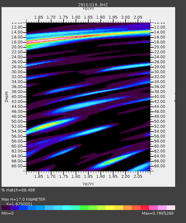
D19 Edge Property, Hiawassee, GA - Earthquake Result Viewer
| Earthquake location: |
Near Coast Of Northern Peru |
| Earthquake latitude/longitude: |
-5.6/-81.0 |
| Earthquake time(UTC): |
2014/03/15 (074) 23:51:33 GMT |
| Earthquake Depth: |
29 km |
| Earthquake Magnitude: |
6.3 MWW, 6.2 MWB, 6.3 MWC |
| Earthquake Catalog/Contributor: |
NEIC PDE/NEIC COMCAT |
|
| Network: |
Z9 Southeastern Suture of the Appalachian Margin Experiment |
| Station: |
D19 Edge Property, Hiawassee, GA |
| Lat/Lon: |
34.87 N/83.73 W |
| Elevation: |
665 m |
|
| Distance: |
40.3 deg |
| Az: |
356.47 deg |
| Baz: |
175.726 deg |
| Ray Param: |
0.07441883 |
| Estimated Moho Depth: |
17.0 km |
| Estimated Crust Vp/Vs: |
1.68 |
| Assumed Crust Vp: |
6.35 km/s |
| Estimated Crust Vs: |
3.791 km/s |
| Estimated Crust Poisson's Ratio: |
0.22 |
|
| Radial Match: |
86.489 % |
| Radial Bump: |
400 |
| Transverse Match: |
65.30786 % |
| Transverse Bump: |
400 |
| SOD ConfigId: |
3390531 |
| Insert Time: |
2019-04-10 16:46:42.450 +0000 |
| GWidth: |
2.5 |
| Max Bumps: |
400 |
| Tol: |
0.001 |
|

Signal To Noise
| Channel | StoN | STA | LTA |
| Z9:D19: :BHZ:20140315T23:58:37.499991Z | 5.569041 | 6.492436E-7 | 1.1658087E-7 |
| Z9:D19: :BHN:20140315T23:58:37.499991Z | 5.5162873 | 4.390547E-7 | 7.9592425E-8 |
| Z9:D19: :BHE:20140315T23:58:37.499991Z | 1.4720036 | 1.6624756E-7 | 1.1293964E-7 |
| Arrivals |
| Ps | 1.9 SECOND |
| PpPs | 6.7 SECOND |
| PsPs/PpSs | 8.6 SECOND |


