
Station Z9 D19 - Edge Property, Hiawassee, GA
Network: Z910 - Southeastern Suture of the Appalachian Margin Experiment
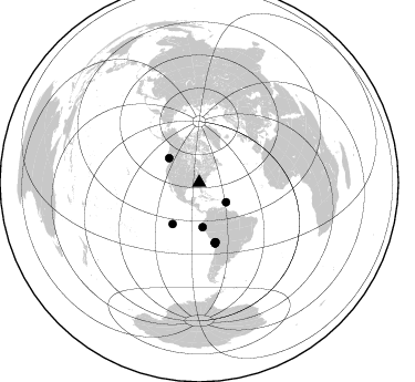
Nearby stations (2 deg radius)
| Station | Name | (Lat, Lon) | Start / End | Elevation |
| D19 | Edge Property, Hiawassee, GA | (34.87, -83.73) | 2012-05-10 / 2014-05-20 | 665 m |
| Crust2 Type: | P6,orogen/43km, Orogen, 0.5 km seds. |
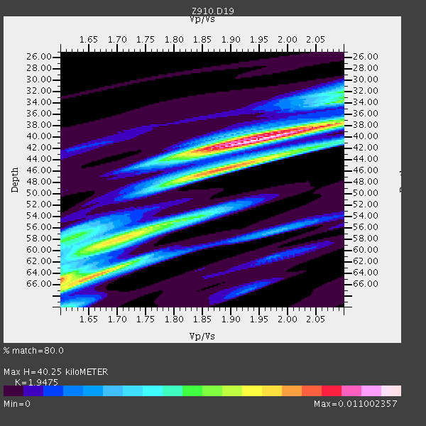
| Thickness Estimate: | 40 km |
| Thickness StdDev: | 11 km |
| Vp/Vs Estimate: | 1.95 |
| Vp/Vs StdDev: | 0.16 |
| Vs Estimate: | 3.261 km/s |
| Poisson's Ratio: | 0.32 |
| Peak Value: | 0.01 |
| Assumed Vp: | 6.35 km/s |
| Ps Weight: | 0.33333334 |
| PpPs Weight: | 0.33333334 |
| PsPs Weight: | 0.33333328 |
| Residual Complexity: | 0.741 |
| Nearby stations H: | +- |
| (2.0 deg) Vp/Vs: | +- |
4 with match > 90% ( 8.333333 %) and 9 with match > 80% ( 18.75 %) out of 48.
Download stack as xyz text file.
Azimuth Distribution of Events:
Prior Results for this Station
| Study | Thickness | Vp/Vs | Vp | Vs | Poissons Ratio | Extra |
| EARS | 40 km | 1.95 | 6.35 km/s | 3.261 km/s | 0.32 | |
| Crust2.0 | 43 km | 1.76 | 6.35 km/s | 3.609 km/s | 0.26 | P6,orogen/43km, Orogen, 0.5 km seds. |
| Global Maxima | 40 km | 1.95 | 6.35 km/s | 3.261 km/s | 0.32 | amp=0.011002357 |
| Local Maxima 1 | 64 km | 1.66 | 6.35 km/s | 3.82 km/s | 0.22 | amp=0.008015975 |
| Local Maxima 2 | 45 km | 1.92 | 6.35 km/s | 3.307 km/s | 0.31 | amp=0.0072873575 |
| Local Maxima 3 | 59 km | 1.66 | 6.35 km/s | 3.814 km/s | 0.22 | amp=0.00611351 |
| Local Maxima 4 | 58 km | 1.62 | 6.35 km/s | 3.932 km/s | 0.19 | amp=0.005126224 |
| Predicted Arrivals for vertical incidence (zero ray parameter) | |
| Ps | 6.01 SECOND |
| PpPs | 18.68 SECOND |
| PsPs/PpSs | 24.69 SECOND |
Events Processed for this Station
Download zip of receiver functions as SAC
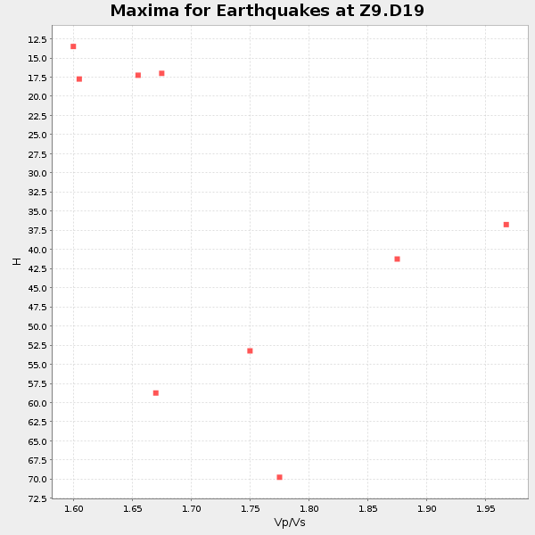
Plot maxima for each earthquake.
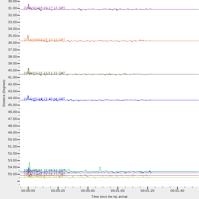
Events Used in the Stack
(9 events)| Radial Match | Distance | Baz | FERegion | Time | Lat/Lon | Depth | Magnitude |
| 95.428665 | 55.9 deg | 165.07 deg | Near Coast Of Northern Chile | 2014/03/16 21:16:30 GMT | (-19.9, -70.6) | 20 km | 6.7 MWW, 6.7 MWC, 7.0 MI |
| 92.736496 | 56.2 deg | 165.083 deg | Near Coast Of Northern Chile | 2014/04/03 01:58:31 GMT | (-20.3, -70.6) | 23 km | 6.5 MWW, 6.5 MWB, 6.6 MWC |
| 92.685196 | 55.7 deg | 165.299 deg | Near Coast Of Northern Chile | 2014/03/22 12:59:59 GMT | (-19.8, -70.9) | 20 km | 6.2 MWW, 6.2 MWB, 6.3 MWC, 6.4 MWC |
| 92.02192 | 30.1 deg | 125.852 deg | North Atlantic Ocean | 2014/02/18 09:27:13 GMT | (14.7, -58.9) | 17 km | 6.5 MWW, 6.3 MWB, 6.5 MWC, 6.6 MWC, 6.7 MI |
| 88.68714 | 56.6 deg | 165.379 deg | Near Coast Of Northern Chile | 2014/04/04 01:37:51 GMT | (-20.6, -70.7) | 20 km | 6.1 MWP, 6.1 MWB, 6.1 MWW, 6.3 MWC |
| 88.39 | 55.6 deg | 164.438 deg | Near Coast Of Northern Chile | 2014/04/01 23:59:57 GMT | (-19.5, -70.2) | 22 km | 5.8 MB |
| 86.958755 | 35.0 deg | 308.858 deg | Vancouver Island, Canada Region | 2014/04/24 03:10:13 GMT | (49.8, -127.4) | 11 km | 6.7 MWP, 6.7 MI |
| 86.489 | 40.3 deg | 175.726 deg | Near Coast Of Northern Peru | 2014/03/15 23:51:33 GMT | (-5.6, -81.0) | 29 km | 6.3 MWW, 6.2 MWB, 6.3 MWC |
| 85.425316 | 44.4 deg | 212.722 deg | Central East Pacific Rise | 2014/05/18 23:47:04 GMT | (-4.5, -106.0) | 17 km | 5.9 MW |
Losers
(39 events)| Radial Match | Distance | Baz | FERegion | Time | Lat/Lon | Depth | Magnitude | Reason |
| 98.505394 | 55.6 deg | 165.203 deg | Near Coast Of Northern Chile | 2014/04/01 23:46:46 GMT | (-19.6, -70.8) | 20 km | 8.2 MWW, 8.0 MI, 8.1 MWC | |
| 98.24225 | 56.5 deg | 165.087 deg | Near Coast Of Northern Chile | 2014/04/03 02:43:14 GMT | (-20.5, -70.5) | 31 km | 7.7 MWW, 7.4 MI, 7.7 MWC | |
| 96.092384 | 33.0 deg | 292.856 deg | Off Coast Of Northern California | 2014/03/10 05:18:13 GMT | (40.8, -125.1) | 17 km | 6.8 MW, 6.8 MWR, 6.9 MWW, 6.9 MWB, 7.0 MI, 7.0 MWC | |
| 89.98556 | 56.8 deg | 165.256 deg | Near Coast Of Northern Chile | 2014/04/03 05:28:50 GMT | (-20.8, -70.6) | 11 km | 5.6 mb | |
| 87.3023 | 56.8 deg | 165.05 deg | Near Coast Of Northern Chile | 2014/04/03 05:51:44 GMT | (-20.8, -70.4) | 27 km | 5.5 MB, 5.3 MWR | |
| 80.27497 | 55.8 deg | 165.277 deg | Near Coast Of Northern Chile | 2014/03/23 20:23:04 GMT | (-19.9, -70.8) | 23 km | 5.3 MW | |
| 78.29119 | 49.9 deg | 322.358 deg | Southern Alaska | 2014/05/10 14:16:08 GMT | (60.0, -152.2) | 96 km | 5.8 ML, 5.5 MI, 5.7 MWP | |
| 75.926575 | 34.3 deg | 294.915 deg | Off Coast Of Northern California | 2014/03/13 19:11:34 GMT | (41.9, -126.9) | 10 km | 5.5 MWW, 4.0 ML, 5.5 MWC, 5.6 MI | |
| 75.78392 | 44.5 deg | 211.917 deg | Central East Pacific Rise | 2014/05/19 01:53:54 GMT | (-4.8, -105.5) | 10 km | 5.5 MWB, 5.6 MWC | |
| 75.368416 | 53.9 deg | 332.356 deg | Northern Alaska | 2014/05/03 08:57:12 GMT | (67.6, -162.2) | 0.9 km | 5.5 MB | |
| 74.4131 | 49.4 deg | 169.584 deg | Near Coast Of Peru | 2014/02/18 23:35:58 GMT | (-14.2, -75.6) | 57 km | 6.0 MWB, 5.9 MWW, 5.9 MWC, 6.0 MWC | |
| 70.278336 | 55.8 deg | 165.195 deg | Near Coast Of Northern Chile | 2014/03/24 11:26:39 GMT | (-19.8, -70.8) | 22 km | 5.7 MWW, 5.7 MWB, 5.8 MWC | |
| 68.51359 | 49.2 deg | 170.467 deg | Near Coast Of Peru | 2014/03/15 08:59:21 GMT | (-14.1, -76.3) | 20 km | 6.1 MWW, 6.0 MWB, 6.2 MWC | |
| 68.5073 | 55.7 deg | 165.224 deg | Near Coast Of Northern Chile | 2014/03/23 18:20:03 GMT | (-19.7, -70.8) | 35 km | 6.0 MB, 6.2 MWB, 6.2 MWW, 6.3 MWC | |
| 68.19684 | 56.1 deg | 165.396 deg | Near Coast Of Northern Chile | 2014/04/07 13:43:20 GMT | (-20.2, -70.9) | 7.9 km | 5.8 MWB, 5.7 MWW, 5.7 MWC | |
| 64.936195 | 56.7 deg | 165.233 deg | Near Coast Of Northern Chile | 2014/04/03 02:56:06 GMT | (-20.7, -70.6) | 17 km | 5.6 MB | |
| 64.60727 | 61.7 deg | 317.455 deg | Fox Islands, Aleutian Islands | 2014/02/26 21:13:40 GMT | (53.6, -171.8) | 265 km | 6.1 MWW, 5.9 MI, 5.9 ML, 6.1 MWC, 6.1 MWB, 6.2 MWC | |
| 64.29341 | 40.4 deg | 175.724 deg | Near Coast Of Northern Peru | 2014/03/22 00:38:45 GMT | (-5.6, -81.0) | 37 km | 4.9 mb | |
| 63.76928 | 54.0 deg | 332.415 deg | Northern Alaska | 2014/04/18 18:44:17 GMT | (67.7, -162.5) | 1.0 km | 5.5 MB, 5.4 MI | |
| 62.790913 | 44.5 deg | 212.738 deg | Central East Pacific Rise | 2014/01/07 23:02:53 GMT | (-4.5, -106.1) | 10 km | 5.7 MWB, 5.8 MWC | |
| 61.800266 | 76.5 deg | 52.028 deg | Southern Italy | 2014/04/05 10:24:45 GMT | (38.9, 17.2) | 56 km | 4.8 MW | |
| 61.308334 | 84.9 deg | 324.749 deg | Kuril Islands | 2014/01/06 07:27:20 GMT | (46.2, 152.1) | 100 km | 3.5 mb | |
| 58.574516 | 66.9 deg | 317.046 deg | Andreanof Islands, Aleutian Is. | 2014/01/16 07:33:09 GMT | (51.2, -179.2) | 27 km | 5.5 MWB, 5.2 ML, 5.5 ML, 5.6 MWC | |
| 58.194523 | 71.2 deg | 321.933 deg | Near Islands, Aleutian Islands | 2014/04/07 07:48:29 GMT | (53.0, 171.0) | 26 km | 5.2 MW | |
| 57.272533 | 68.3 deg | 168.997 deg | Near Coast Of Central Chile | 2014/04/05 02:22:38 GMT | (-32.8, -71.6) | 40 km | 5.6 MWC, 5.6 MWC | |
| 57.264626 | 56.7 deg | 165.293 deg | Near Coast Of Northern Chile | 2014/01/06 03:59:02 GMT | (-20.7, -70.6) | 27 km | 5.2 MW | |
| 56.240196 | 80.8 deg | 324.737 deg | Kuril Islands | 2014/01/19 00:52:35 GMT | (49.1, 156.4) | 34 km | 4.9 MW | |
| 53.067314 | 80.5 deg | 174.649 deg | Off Coast Of Southern Chile | 2014/03/02 17:03:43 GMT | (-45.8, -76.2) | 10 km | 5.4 MW | |
| 52.777718 | 96.6 deg | 325.424 deg | Near East Coast Of Honshu, Japan | 2014/02/07 17:18:33 GMT | (37.5, 141.4) | 57 km | 5.0 MW | |
| 49.690662 | 95.3 deg | 325.522 deg | Near East Coast Of Honshu, Japan | 2014/02/05 17:32:13 GMT | (38.7, 142.4) | 46 km | 5.3 MW | |
| 47.67678 | 69.0 deg | 169.488 deg | Near Coast Of Central Chile | 2014/03/04 10:51:15 GMT | (-33.6, -72.0) | 20 km | 5.7 MWW, 5.7 MWB, 5.8 MWC | |
| 47.04403 | 92.6 deg | 330.32 deg | Eastern Sea Of Japan | 2014/01/11 03:56:48 GMT | (43.7, 139.2) | 230 km | 5.0 MW | |
| 46.501873 | 80.2 deg | 328.291 deg | Northwest Of Kuril Islands | 2014/03/12 18:18:40 GMT | (52.0, 153.2) | 418 km | 5.1 MW | |
| 46.32526 | 96.9 deg | 203.18 deg | Southern East Pacific Rise | 2014/02/01 09:17:26 GMT | (-55.1, -126.6) | 10 km | 5.2 MW | |
| 41.37631 | 57.0 deg | 157.56 deg | Southern Bolivia | 2014/01/27 16:42:37 GMT | (-19.3, -63.9) | 600 km | 5.6 MWB | |
| 40.05916 | 55.9 deg | 165.458 deg | Near Coast Of Northern Chile | 2014/04/02 11:07:33 GMT | (-20.0, -71.0) | 27 km | 5.4 Mww | |
| 39.9997 | 79.9 deg | 325.731 deg | Kuril Islands | 2014/04/07 09:34:49 GMT | (50.4, 156.3) | 85 km | 5.2 MW | |
| 38.59394 | 97.8 deg | 204.576 deg | Pacific-Antarctic Ridge | 2014/04/17 13:10:06 GMT | (-55.1, -129.5) | 16 km | 5.5 MB, 5.7 MWC | |
| 36.132877 | 78.9 deg | 51.081 deg | Greece | 2014/02/03 03:08:46 GMT | (38.3, 20.4) | 5.0 km | 6.0 MWW, 6.0 MWB, 6.1 MWC |

