You are here: Home > Network List > Z910 - Southeastern Suture of the Appalachian Margin Experiment Stations List
> Station D21 Gore Property, Murphy, NC > Earthquake Result Viewer
D21 Gore Property, Murphy, NC - Earthquake Result Viewer
| Earthquake location: |
Near Coast Of Northern Peru |
| Earthquake latitude/longitude: |
-5.6/-81.0 |
| Earthquake time(UTC): |
2014/03/15 (074) 23:51:33 GMT |
| Earthquake Depth: |
29 km |
| Earthquake Magnitude: |
6.3 MWW, 6.2 MWB, 6.3 MWC |
| Earthquake Catalog/Contributor: |
NEIC PDE/NEIC COMCAT |
|
| Network: |
Z9 Southeastern Suture of the Appalachian Margin Experiment |
| Station: |
D21 Gore Property, Murphy, NC |
| Lat/Lon: |
35.20 N/84.14 W |
| Elevation: |
526 m |
|
| Distance: |
40.7 deg |
| Az: |
356.002 deg |
| Baz: |
175.14 deg |
| Ray Param: |
0.07421128 |
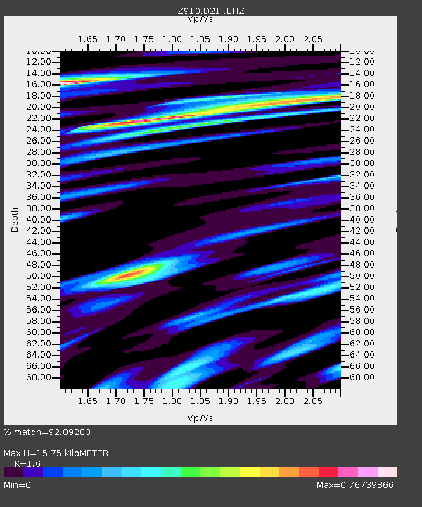
| Estimated Moho Depth: |
15.75 km |
| Estimated Crust Vp/Vs: |
1.60 |
| Assumed Crust Vp: |
6.35 km/s |
| Estimated Crust Vs: |
3.969 km/s |
| Estimated Crust Poisson's Ratio: |
0.18 |
|
| Radial Match: |
92.09283 % |
| Radial Bump: |
393 |
| Transverse Match: |
61.26759 % |
| Transverse Bump: |
400 |
| SOD ConfigId: |
3390531 |
| Insert Time: |
2019-04-10 16:46:44.560 +0000 |
| GWidth: |
2.5 |
| Max Bumps: |
400 |
| Tol: |
0.001 |
|

Signal To Noise
| Channel | StoN | STA | LTA |
| Z9:D21: :BHZ:20140315T23:58:40.399985Z | 6.319494 | 1.0589041E-6 | 1.6756154E-7 |
| Z9:D21: :BHN:20140315T23:58:40.399985Z | 4.644729 | 6.4406294E-7 | 1.3866534E-7 |
| Z9:D21: :BHE:20140315T23:58:40.399985Z | 2.4652255 | 2.787486E-7 | 1.1307225E-7 |
| Arrivals |
| Ps | 1.6 SECOND |
| PpPs | 6.0 SECOND |
| PsPs/PpSs | 7.6 SECOND |


