
Station Z9 D21 - Gore Property, Murphy, NC
Network: Z910 - Southeastern Suture of the Appalachian Margin Experiment
Nearby stations (2 deg radius)
| Station | Name | (Lat, Lon) | Start / End | Elevation |
| D21 | Gore Property, Murphy, NC | (35.20, -84.14) | 2012-05-10 / 2014-05-19 | 526 m |
| Crust2 Type: | P6,orogen/43km, Orogen, 0.5 km seds. |
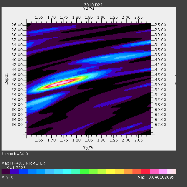
| Thickness Estimate: | 50 km |
| Thickness StdDev: | 0.6 km |
| Vp/Vs Estimate: | 1.72 |
| Vp/Vs StdDev: | 0.02 |
| Vs Estimate: | 3.687 km/s |
| Poisson's Ratio: | 0.25 |
| Peak Value: | 0.04 |
| Assumed Vp: | 6.35 km/s |
| Ps Weight: | 0.33333334 |
| PpPs Weight: | 0.33333334 |
| PsPs Weight: | 0.33333328 |
| Residual Complexity: | 0.455 |
| Nearby stations H: | +- |
| (2.0 deg) Vp/Vs: | +- |
3 with match > 90% ( 7.6923075 %) and 7 with match > 80% ( 17.948717 %) out of 39.
Download stack as xyz text file.
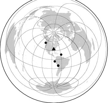
Azimuth Distribution of Events:
Prior Results for this Station
| Study | Thickness | Vp/Vs | Vp | Vs | Poissons Ratio | Extra |
| EARS | 50 km | 1.72 | 6.35 km/s | 3.687 km/s | 0.25 | |
| Crust2.0 | 43 km | 1.76 | 6.35 km/s | 3.609 km/s | 0.26 | P6,orogen/43km, Orogen, 0.5 km seds. |
| Global Maxima | 50 km | 1.72 | 6.35 km/s | 3.687 km/s | 0.25 | amp=0.040182695 |
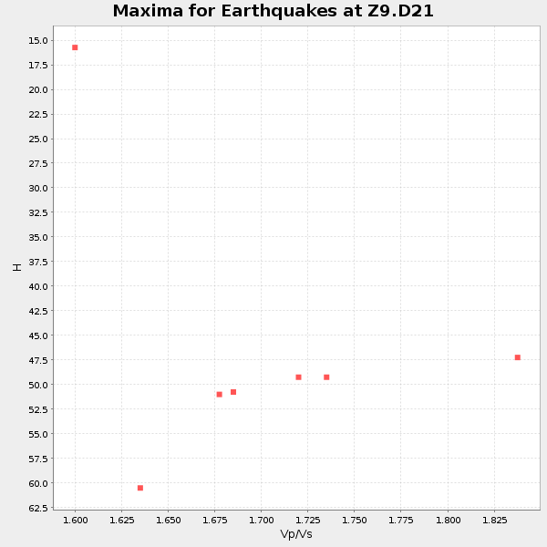
| Local Maxima 1 | 47 km | 1.80 | 6.35 km/s | 3.523 km/s | 0.28 | amp=0.016125752 |
| Local Maxima 2 | 32 km | 2.10 | 6.35 km/s | 3.027 km/s | 0.35 | amp=0.009675932 |
| Local Maxima 3 | 38 km | 2.03 | 6.35 km/s | 3.132 km/s | 0.34 | amp=0.008625728 |
| Local Maxima 4 | 39 km | 1.87 | 6.35 km/s | 3.391 km/s | 0.30 | amp=0.0058907126 |
| Predicted Arrivals for vertical incidence (zero ray parameter) | |
| Ps | 5.63 SECOND |
| PpPs | 21.22 SECOND |
| PsPs/PpSs | 26.85 SECOND |
Events Processed for this Station
Download zip of receiver functions as SAC
Plot maxima for each earthquake.
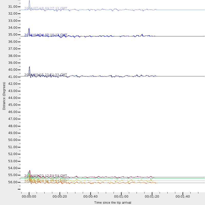
Events Used in the Stack
(7 events)| Radial Match | Distance | Baz | FERegion | Time | Lat/Lon | Depth | Magnitude |
| 94.393364 | 56.1 deg | 164.909 deg | Near Coast Of Northern Chile | 2014/03/22 12:59:59 GMT | (-19.8, -70.9) | 20 km | 6.2 MWW, 6.2 MWB, 6.3 MWC, 6.4 MWC |
| 94.02964 | 56.3 deg | 164.682 deg | Near Coast Of Northern Chile | 2014/03/16 21:16:30 GMT | (-19.9, -70.6) | 20 km | 6.7 MWW, 6.7 MWC, 7.0 MI |
| 92.09283 | 40.7 deg | 175.14 deg | Near Coast Of Northern Peru | 2014/03/15 23:51:33 GMT | (-5.6, -81.0) | 29 km | 6.3 MWW, 6.2 MWB, 6.3 MWC |
| 89.697754 | 34.6 deg | 308.558 deg | Vancouver Island, Canada Region | 2014/04/24 03:10:13 GMT | (49.8, -127.4) | 11 km | 6.7 MWP, 6.7 MI |
| 88.12461 | 57.0 deg | 164.993 deg | Near Coast Of Northern Chile | 2014/04/04 01:37:51 GMT | (-20.6, -70.7) | 20 km | 6.1 MWP, 6.1 MWB, 6.1 MWW, 6.3 MWC |
| 85.72571 | 56.6 deg | 164.697 deg | Near Coast Of Northern Chile | 2014/04/03 01:58:31 GMT | (-20.3, -70.6) | 23 km | 6.5 MWW, 6.5 MWB, 6.6 MWC |
| 85.256744 | 30.5 deg | 125.744 deg | North Atlantic Ocean | 2014/02/18 09:27:13 GMT | (14.7, -58.9) | 17 km | 6.5 MWW, 6.3 MWB, 6.5 MWC, 6.6 MWC, 6.7 MI |
Losers
(32 events)| Radial Match | Distance | Baz | FERegion | Time | Lat/Lon | Depth | Magnitude | Reason |
| 98.330734 | 56.0 deg | 164.813 deg | Near Coast Of Northern Chile | 2014/04/01 23:46:46 GMT | (-19.6, -70.8) | 20 km | 8.2 MWW, 8.0 MI, 8.1 MWC | |
| 96.76282 | 56.9 deg | 164.703 deg | Near Coast Of Northern Chile | 2014/04/03 02:43:14 GMT | (-20.5, -70.5) | 31 km | 7.7 MWW, 7.4 MI, 7.7 MWC | |
| 96.52864 | 32.6 deg | 292.355 deg | Off Coast Of Northern California | 2014/03/10 05:18:13 GMT | (40.8, -125.1) | 17 km | 6.8 MW, 6.8 MWR, 6.9 MWW, 6.9 MWB, 7.0 MI, 7.0 MWC | |
| 94.5501 | 57.2 deg | 164.667 deg | Near Coast Of Northern Chile | 2014/04/03 05:51:44 GMT | (-20.8, -70.4) | 27 km | 5.5 MB, 5.3 MWR | |
| 84.15424 | 56.4 deg | 164.688 deg | Near Coast Of Northern Chile | 2014/04/02 00:37:49 GMT | (-20.0, -70.6) | 20 km | 5.4 mb | |
| 84.03541 | 49.4 deg | 322.18 deg | Southern Alaska | 2014/05/10 14:16:08 GMT | (60.0, -152.2) | 96 km | 5.8 ML, 5.5 MI, 5.7 MWP | |
| 79.326645 | 56.1 deg | 164.834 deg | Near Coast Of Northern Chile | 2014/03/23 18:20:03 GMT | (-19.7, -70.8) | 35 km | 6.0 MB, 6.2 MWB, 6.2 MWW, 6.3 MWC | |
| 73.493576 | 57.1 deg | 164.849 deg | Near Coast Of Northern Chile | 2014/04/03 02:56:06 GMT | (-20.7, -70.6) | 17 km | 5.6 MB | |
| 72.84944 | 53.6 deg | 332.288 deg | Northern Alaska | 2014/04/18 18:44:17 GMT | (67.7, -162.5) | 1.0 km | 5.5 MB, 5.4 MI | |
| 71.08171 | 49.6 deg | 170.004 deg | Near Coast Of Peru | 2014/03/15 08:59:21 GMT | (-14.1, -76.3) | 20 km | 6.1 MWW, 6.0 MWB, 6.2 MWC | |
| 68.06723 | 49.8 deg | 169.128 deg | Near Coast Of Peru | 2014/02/18 23:35:58 GMT | (-14.2, -75.6) | 57 km | 6.0 MWB, 5.9 MWW, 5.9 MWC, 6.0 MWC | |
| 67.939575 | 53.6 deg | 332.334 deg | Northern Alaska | 2014/04/18 18:56:47 GMT | (67.7, -162.5) | 17 km | 5.7 MW | |
| 66.51081 | 56.1 deg | 164.916 deg | Near Coast Of Northern Chile | 2014/03/22 13:14:55 GMT | (-19.8, -70.9) | 4.6 km | 5.2 Mww | |
| 65.49846 | 56.0 deg | 164.448 deg | Near Coast Of Northern Chile | 2014/04/02 00:04:54 GMT | (-19.6, -70.5) | 34 km | 5.5 MB | |
| 63.63693 | 56.5 deg | 165.008 deg | Near Coast Of Northern Chile | 2014/04/07 13:43:20 GMT | (-20.2, -70.9) | 7.9 km | 5.8 MWB, 5.7 MWW, 5.7 MWC | |
| 61.731182 | 37.5 deg | 172.009 deg | Near Coast Of Ecuador | 2014/03/25 09:56:28 GMT | (-2.2, -79.3) | 10 km | 5.2 MW | |
| 60.651424 | 56.5 deg | 164.608 deg | Near Coast Of Northern Chile | 2014/04/05 05:44:57 GMT | (-20.1, -70.5) | 39 km | 5.3 MW | |
| 58.929806 | 56.0 deg | 164.051 deg | Near Coast Of Northern Chile | 2014/04/01 23:59:57 GMT | (-19.5, -70.2) | 22 km | 5.8 MB | |
| 58.924976 | 66.4 deg | 316.824 deg | Andreanof Islands, Aleutian Is. | 2014/01/16 07:33:09 GMT | (51.2, -179.2) | 27 km | 5.5 MWB, 5.2 ML, 5.5 ML, 5.6 MWC | |
| 57.138573 | 97.0 deg | 203.002 deg | Southern East Pacific Rise | 2014/02/01 09:17:26 GMT | (-55.1, -126.6) | 10 km | 5.2 MW | |
| 54.356503 | 87.5 deg | 325.289 deg | Kuril Islands | 2014/05/05 14:38:25 GMT | (44.4, 148.4) | 82 km | 4.2 mb | |
| 54.03724 | 53.5 deg | 332.229 deg | Northern Alaska | 2014/05/03 08:57:12 GMT | (67.6, -162.2) | 0.9 km | 5.5 MB | |
| 50.928806 | 70.7 deg | 321.723 deg | Near Islands, Aleutian Islands | 2014/04/07 07:48:29 GMT | (53.0, 171.0) | 26 km | 5.2 MW | |
| 49.611282 | 56.0 deg | 164.803 deg | Near Coast Of Northern Chile | 2014/03/24 15:45:31 GMT | (-19.6, -70.8) | 18 km | 5.6 MWB, 5.5 MWR, 5.7 MWC, 5.7 MWW | |
| 47.751965 | 40.7 deg | 175.138 deg | Near Coast Of Northern Peru | 2014/03/22 00:38:45 GMT | (-5.6, -81.0) | 37 km | 4.9 mb | |
| 46.244797 | 88.9 deg | 199.683 deg | Southern East Pacific Rise | 2014/05/12 20:07:51 GMT | (-49.7, -115.3) | 10 km | 5.4 MW | |
| 44.58149 | 56.8 deg | 164.755 deg | Near Coast Of Northern Chile | 2014/04/02 19:45:49 GMT | (-20.4, -70.6) | 17 km | 5.3 MW | |
| 44.235474 | 61.3 deg | 317.236 deg | Fox Islands, Aleutian Islands | 2014/02/26 21:13:40 GMT | (53.6, -171.8) | 265 km | 6.1 MWW, 5.9 MI, 5.9 ML, 6.1 MWC, 6.1 MWB, 6.2 MWC | |
| 43.057 | 57.5 deg | 157.214 deg | Southern Bolivia | 2014/01/27 16:42:37 GMT | (-19.3, -63.9) | 600 km | 5.6 MWB | |
| 41.77546 | 94.7 deg | 325.949 deg | Eastern Honshu, Japan | 2014/04/02 23:22:47 GMT | (39.2, 141.8) | 56 km | 5.6 MB, 5.5 MWC | |
| 37.900604 | 81.7 deg | 50.134 deg | Southern Greece | 2014/04/04 20:08:07 GMT | (37.2, 23.8) | 107 km | 5.5 MWB, 5.5 MWR, 5.6 MWC, 5.6 MWW | |
| 32.533787 | 88.9 deg | 329.386 deg | Hokkaido, Japan Region | 2014/02/20 23:12:38 GMT | (45.9, 142.6) | 324 km | 5.2 MW |

