You are here: Home > Network List > Z910 - Southeastern Suture of the Appalachian Margin Experiment Stations List
> Station E09 Plum Creek, Winokur, GA > Earthquake Result Viewer
E09 Plum Creek, Winokur, GA - Earthquake Result Viewer
| Earthquake location: |
Near Coast Of Northern Peru |
| Earthquake latitude/longitude: |
-5.6/-81.0 |
| Earthquake time(UTC): |
2014/03/15 (074) 23:51:33 GMT |
| Earthquake Depth: |
29 km |
| Earthquake Magnitude: |
6.3 MWW, 6.2 MWB, 6.3 MWC |
| Earthquake Catalog/Contributor: |
NEIC PDE/NEIC COMCAT |
|
| Network: |
Z9 Southeastern Suture of the Appalachian Margin Experiment |
| Station: |
E09 Plum Creek, Winokur, GA |
| Lat/Lon: |
30.98 N/82.07 W |
| Elevation: |
30 m |
|
| Distance: |
36.4 deg |
| Az: |
358.381 deg |
| Baz: |
178.124 deg |
| Ray Param: |
0.07666612 |
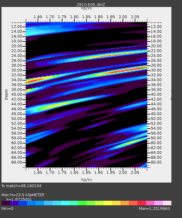
| Estimated Moho Depth: |
23.5 km |
| Estimated Crust Vp/Vs: |
1.97 |
| Assumed Crust Vp: |
6.565 km/s |
| Estimated Crust Vs: |
3.328 km/s |
| Estimated Crust Poisson's Ratio: |
0.33 |
|
| Radial Match: |
89.160194 % |
| Radial Bump: |
400 |
| Transverse Match: |
61.288284 % |
| Transverse Bump: |
400 |
| SOD ConfigId: |
3390531 |
| Insert Time: |
2019-04-10 16:46:49.502 +0000 |
| GWidth: |
2.5 |
| Max Bumps: |
400 |
| Tol: |
0.001 |
|

Signal To Noise
| Channel | StoN | STA | LTA |
| Z9:E09: :BHZ:20140315T23:58:04.379996Z | 4.0028496 | 6.951817E-7 | 1.736717E-7 |
| Z9:E09: :BHN:20140315T23:58:04.379996Z | 2.8868024 | 5.6419555E-7 | 1.9543961E-7 |
| Z9:E09: :BHE:20140315T23:58:04.379996Z | 1.0996021 | 2.7941175E-7 | 2.541026E-7 |
| Arrivals |
| Ps | 3.7 SECOND |
| PpPs | 9.9 SECOND |
| PsPs/PpSs | 14 SECOND |


