
Station Z9 E09 - Plum Creek, Winokur, GA
Network: Z910 - Southeastern Suture of the Appalachian Margin Experiment
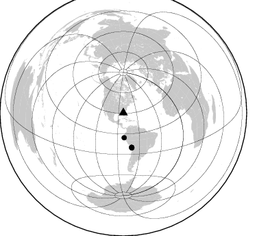
Nearby stations (2 deg radius)
| Station | Name | (Lat, Lon) | Start / End | Elevation |
| E09 | Plum Creek, Winokur, GA | (30.98, -82.07) | 2012-09-16 / 2014-05-16 | 30 m |
| Crust2 Type: | DG,thin Platform 1 km seds. |
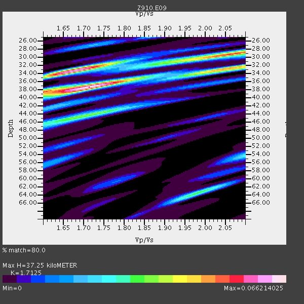
| Thickness Estimate: | 37 km |
| Thickness StdDev: | 2.9 km |
| Vp/Vs Estimate: | 1.71 |
| Vp/Vs StdDev: | 0.13 |
| Vs Estimate: | 3.833 km/s |
| Poisson's Ratio: | 0.24 |
| Peak Value: | 0.07 |
| Assumed Vp: | 6.565 km/s |
| Ps Weight: | 0.33333334 |
| PpPs Weight: | 0.33333334 |
| PsPs Weight: | 0.33333328 |
| Residual Complexity: | 0.737 |
| Nearby stations H: | +- |
| (2.0 deg) Vp/Vs: | +- |
1 with match > 90% ( 5.0 %) and 5 with match > 80% ( 25.0 %) out of 20.
Download stack as xyz text file.
Azimuth Distribution of Events:
Prior Results for this Station
| Study | Thickness | Vp/Vs | Vp | Vs | Poissons Ratio | Extra |
| EARS | 37 km | 1.71 | 6.565 km/s | 3.833 km/s | 0.24 | |
| Crust2.0 | 31 km | 1.78 | 6.565 km/s | 3.684 km/s | 0.27 | DG,thin Platform 1 km seds. |
| Global Maxima | 37 km | 1.71 | 6.565 km/s | 3.833 km/s | 0.24 | amp=0.066214025 |
| Local Maxima 1 | 33 km | 1.68 | 6.565 km/s | 3.919 km/s | 0.22 | amp=0.06135906 |
| Local Maxima 2 | 32 km | 2.06 | 6.565 km/s | 3.183 km/s | 0.35 | amp=0.038414072 |
| Local Maxima 3 | 29 km | 2.06 | 6.565 km/s | 3.194 km/s | 0.34 | amp=0.0351404 |
| Local Maxima 4 | 44 km | 1.72 | 6.565 km/s | 3.822 km/s | 0.24 | amp=0.03380645 |
| Predicted Arrivals for vertical incidence (zero ray parameter) | |
| Ps | 4.04 SECOND |
| PpPs | 15.39 SECOND |
| PsPs/PpSs | 19.43 SECOND |
Events Processed for this Station
Download zip of receiver functions as SAC
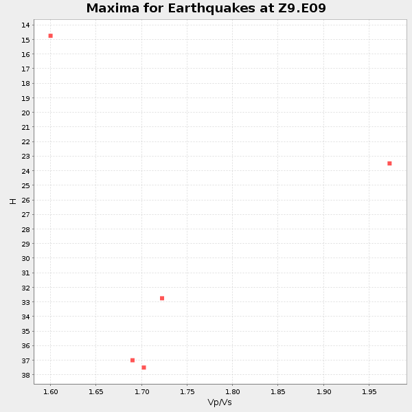
Plot maxima for each earthquake.
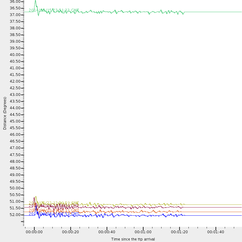
Events Used in the Stack
(5 events)| Radial Match | Distance | Baz | FERegion | Time | Lat/Lon | Depth | Magnitude |
| 93.46905 | 52.1 deg | 166.265 deg | Near Coast Of Northern Chile | 2014/04/03 01:58:31 GMT | (-20.3, -70.6) | 23 km | 6.5 MWW, 6.5 MWB, 6.6 MWC |
| 89.71771 | 51.6 deg | 166.499 deg | Near Coast Of Northern Chile | 2014/03/22 12:59:59 GMT | (-19.8, -70.9) | 20 km | 6.2 MWW, 6.2 MWB, 6.3 MWC, 6.4 MWC |
| 89.160194 | 36.4 deg | 178.124 deg | Near Coast Of Northern Peru | 2014/03/15 23:51:33 GMT | (-5.6, -81.0) | 29 km | 6.3 MWW, 6.2 MWB, 6.3 MWC |
| 88.72027 | 52.5 deg | 166.573 deg | Near Coast Of Northern Chile | 2014/04/04 01:37:51 GMT | (-20.6, -70.7) | 20 km | 6.1 MWP, 6.1 MWB, 6.1 MWW, 6.3 MWC |
| 87.9582 | 51.8 deg | 166.255 deg | Near Coast Of Northern Chile | 2014/03/16 21:16:30 GMT | (-19.9, -70.6) | 20 km | 6.7 MWW, 6.7 MWC, 7.0 MI |
Losers
(15 events)| Radial Match | Distance | Baz | FERegion | Time | Lat/Lon | Depth | Magnitude | Reason |
| 98.630684 | 51.5 deg | 166.399 deg | Near Coast Of Northern Chile | 2014/04/01 23:46:46 GMT | (-19.6, -70.8) | 20 km | 8.2 MWW, 8.0 MI, 8.1 MWC | |
| 97.43863 | 52.4 deg | 166.266 deg | Near Coast Of Northern Chile | 2014/04/03 02:43:14 GMT | (-20.5, -70.5) | 31 km | 7.7 MWW, 7.4 MI, 7.7 MWC | |
| 93.277664 | 35.9 deg | 297.987 deg | Off Coast Of Northern California | 2014/03/10 05:18:13 GMT | (40.8, -125.1) | 17 km | 6.8 MW, 6.8 MWR, 6.9 MWW, 6.9 MWB, 7.0 MI, 7.0 MWC | |
| 91.761894 | 51.5 deg | 166.386 deg | Near Coast Of Northern Chile | 2014/04/02 00:06:44 GMT | (-19.6, -70.8) | 10 km | 5.7 MB | |
| 80.54127 | 52.7 deg | 166.442 deg | Near Coast Of Northern Chile | 2014/04/03 05:28:50 GMT | (-20.8, -70.6) | 11 km | 5.6 mb | |
| 74.640236 | 51.9 deg | 166.26 deg | Near Coast Of Northern Chile | 2014/04/02 00:37:49 GMT | (-20.0, -70.6) | 20 km | 5.4 mb | |
| 70.73294 | 52.7 deg | 166.403 deg | Near Coast Of Northern Chile | 2014/04/03 05:26:16 GMT | (-20.8, -70.5) | 24 km | 6.2 MWP, 6.2 MWR, 6.3 MWW, 6.5 MWC | |
| 68.24621 | 45.2 deg | 172.099 deg | Near Coast Of Peru | 2014/03/15 08:59:21 GMT | (-14.1, -76.3) | 20 km | 6.1 MWW, 6.0 MWB, 6.2 MWC | |
| 66.12594 | 51.6 deg | 166.42 deg | Near Coast Of Northern Chile | 2014/03/23 18:20:03 GMT | (-19.7, -70.8) | 35 km | 6.0 MB, 6.2 MWB, 6.2 MWW, 6.3 MWC | |
| 58.75339 | 88.1 deg | 325.237 deg | Kuril Islands | 2014/01/20 00:56:36 GMT | (46.4, 153.4) | 43 km | 4.8 mb | |
| 57.716724 | 51.4 deg | 166.52 deg | Near Coast Of Northern Chile | 2014/04/02 01:20:59 GMT | (-19.6, -70.9) | 22 km | 5.2 mb | |
| 55.637775 | 65.6 deg | 319.115 deg | Fox Islands, Aleutian Islands | 2014/02/26 21:13:40 GMT | (53.6, -171.8) | 265 km | 6.1 MWW, 5.9 MI, 5.9 ML, 6.1 MWC, 6.1 MWB, 6.2 MWC | |
| 49.723057 | 52.9 deg | 158.346 deg | Southern Bolivia | 2014/01/27 16:42:37 GMT | (-19.3, -63.9) | 600 km | 5.6 MWB | |
| 49.603954 | 52.0 deg | 166.597 deg | Near Coast Of Northern Chile | 2014/04/07 13:43:20 GMT | (-20.2, -70.9) | 7.9 km | 5.8 MWB, 5.7 MWW, 5.7 MWC | |
| 45.494274 | 83.0 deg | 50.672 deg | Southern Greece | 2014/04/04 20:08:07 GMT | (37.2, 23.8) | 107 km | 5.5 MWB, 5.5 MWR, 5.6 MWC, 5.6 MWW |

