You are here: Home > Network List > Z910 - Southeastern Suture of the Appalachian Margin Experiment Stations List
> Station E16 Chancey Property, Patterson, GA > Earthquake Result Viewer
E16 Chancey Property, Patterson, GA - Earthquake Result Viewer
| Earthquake location: |
Near Coast Of Northern Peru |
| Earthquake latitude/longitude: |
-5.6/-81.0 |
| Earthquake time(UTC): |
2014/03/15 (074) 23:51:33 GMT |
| Earthquake Depth: |
29 km |
| Earthquake Magnitude: |
6.3 MWW, 6.2 MWB, 6.3 MWC |
| Earthquake Catalog/Contributor: |
NEIC PDE/NEIC COMCAT |
|
| Network: |
Z9 Southeastern Suture of the Appalachian Margin Experiment |
| Station: |
E16 Chancey Property, Patterson, GA |
| Lat/Lon: |
31.45 N/82.13 W |
| Elevation: |
46 m |
|
| Distance: |
36.8 deg |
| Az: |
358.327 deg |
| Baz: |
178.052 deg |
| Ray Param: |
0.076412216 |
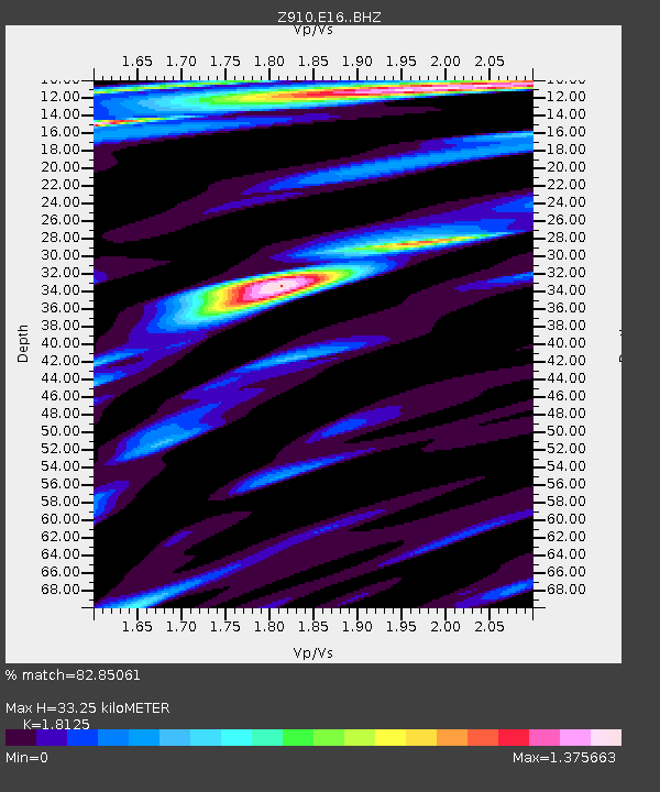
| Estimated Moho Depth: |
33.25 km |
| Estimated Crust Vp/Vs: |
1.81 |
| Assumed Crust Vp: |
6.565 km/s |
| Estimated Crust Vs: |
3.622 km/s |
| Estimated Crust Poisson's Ratio: |
0.28 |
|
| Radial Match: |
82.85061 % |
| Radial Bump: |
400 |
| Transverse Match: |
65.09833 % |
| Transverse Bump: |
400 |
| SOD ConfigId: |
3390531 |
| Insert Time: |
2019-04-10 16:46:52.617 +0000 |
| GWidth: |
2.5 |
| Max Bumps: |
400 |
| Tol: |
0.001 |
|

Signal To Noise
| Channel | StoN | STA | LTA |
| Z9:E16: :BHZ:20140315T23:58:08.339988Z | 4.8899984 | 9.1853667E-7 | 1.8783989E-7 |
| Z9:E16: :BHN:20140315T23:58:08.339988Z | 1.5885957 | 5.359931E-7 | 3.3740054E-7 |
| Z9:E16: :BHE:20140315T23:58:08.339988Z | 1.2844164 | 3.8626396E-7 | 3.007311E-7 |
| Arrivals |
| Ps | 4.4 SECOND |
| PpPs | 13 SECOND |
| PsPs/PpSs | 18 SECOND |


