
Station Z9 E16 - Chancey Property, Patterson, GA
Network: Z910 - Southeastern Suture of the Appalachian Margin Experiment
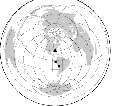
Nearby stations (2 deg radius)
| Station | Name | (Lat, Lon) | Start / End | Elevation |
| E16 | Chancey Property, Patterson, GA | (31.45, -82.13) | 2012-05-09 / 2014-05-16 | 46 m |
| Crust2 Type: | DG,thin Platform 1 km seds. |
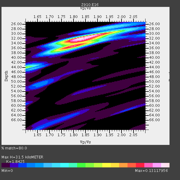
| Thickness Estimate: | 32 km |
| Thickness StdDev: | 1.2 km |
| Vp/Vs Estimate: | 1.84 |
| Vp/Vs StdDev: | 0.04 |
| Vs Estimate: | 3.563 km/s |
| Poisson's Ratio: | 0.29 |
| Peak Value: | 0.13 |
| Assumed Vp: | 6.565 km/s |
| Ps Weight: | 0.33333334 |
| PpPs Weight: | 0.33333334 |
| PsPs Weight: | 0.33333328 |
| Residual Complexity: | 0.514 |
| Nearby stations H: | +- |
| (2.0 deg) Vp/Vs: | +- |
2 with match > 90% ( 12.5 %) and 3 with match > 80% ( 18.75 %) out of 16.
Download stack as xyz text file.
Azimuth Distribution of Events:
Prior Results for this Station
| Study | Thickness | Vp/Vs | Vp | Vs | Poissons Ratio | Extra |
| EARS | 32 km | 1.84 | 6.565 km/s | 3.563 km/s | 0.29 | |
| Crust2.0 | 31 km | 1.78 | 6.565 km/s | 3.684 km/s | 0.27 | DG,thin Platform 1 km seds. |
| Global Maxima | 32 km | 1.84 | 6.565 km/s | 3.563 km/s | 0.29 | amp=0.13117956 |
| Local Maxima 1 | 35 km | 1.80 | 6.565 km/s | 3.647 km/s | 0.28 | amp=0.08954252 |
| Local Maxima 2 | 44 km | 1.61 | 6.565 km/s | 4.09 km/s | 0.18 | amp=0.06428063 |
| Local Maxima 3 | 33 km | 1.83 | 6.565 km/s | 3.582 km/s | 0.29 | amp=0.05139466 |
| Local Maxima 4 | 29 km | 1.97 | 6.565 km/s | 3.341 km/s | 0.33 | amp=0.03387502 |
| Predicted Arrivals for vertical incidence (zero ray parameter) | |
| Ps | 4.04 SECOND |
| PpPs | 13.64 SECOND |
| PsPs/PpSs | 17.68 SECOND |
Events Processed for this Station
Download zip of receiver functions as SAC
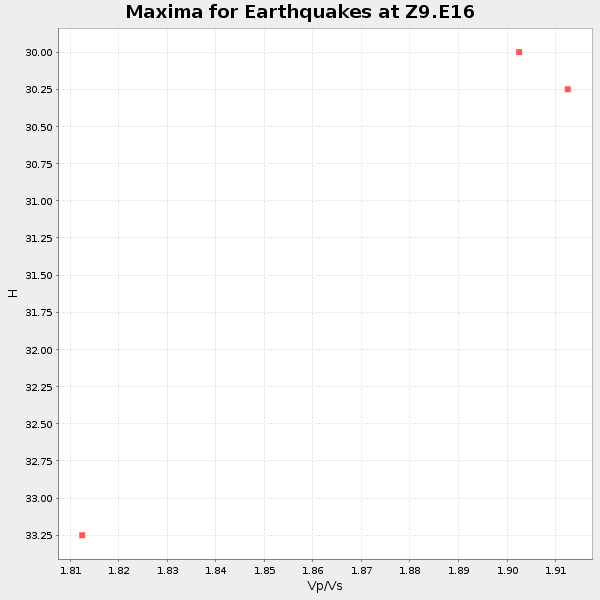
Plot maxima for each earthquake.
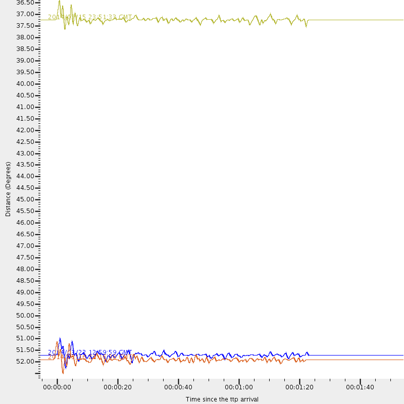
Events Used in the Stack
(3 events)| Radial Match | Distance | Baz | FERegion | Time | Lat/Lon | Depth | Magnitude |
| 90.67938 | 52.1 deg | 166.519 deg | Near Coast Of Northern Chile | 2014/03/22 12:59:59 GMT | (-19.8, -70.9) | 20 km | 6.2 MWW, 6.2 MWB, 6.3 MWC, 6.4 MWC |
| 90.47977 | 52.3 deg | 166.276 deg | Near Coast Of Northern Chile | 2014/03/16 21:16:30 GMT | (-19.9, -70.6) | 20 km | 6.7 MWW, 6.7 MWC, 7.0 MI |
| 82.85061 | 36.8 deg | 178.052 deg | Near Coast Of Northern Peru | 2014/03/15 23:51:33 GMT | (-5.6, -81.0) | 29 km | 6.3 MWW, 6.2 MWB, 6.3 MWC |
Losers
(13 events)| Radial Match | Distance | Baz | FERegion | Time | Lat/Lon | Depth | Magnitude | Reason |
| 94.36687 | 51.9 deg | 166.42 deg | Near Coast Of Northern Chile | 2014/04/01 23:46:46 GMT | (-19.6, -70.8) | 20 km | 8.2 MWW, 8.0 MI, 8.1 MWC | |
| 88.64624 | 35.7 deg | 297.418 deg | Off Coast Of Northern California | 2014/03/10 05:18:13 GMT | (40.8, -125.1) | 17 km | 6.8 MW, 6.8 MWR, 6.9 MWW, 6.9 MWB, 7.0 MI, 7.0 MWC | |
| 76.152756 | 52.0 deg | 166.44 deg | Near Coast Of Northern Chile | 2014/03/23 18:20:03 GMT | (-19.7, -70.8) | 35 km | 6.0 MB, 6.2 MWB, 6.2 MWW, 6.3 MWC | |
| 73.46847 | 45.8 deg | 171.149 deg | Near Coast Of Peru | 2014/02/18 23:35:58 GMT | (-14.2, -75.6) | 57 km | 6.0 MWB, 5.9 MWW, 5.9 MWC, 6.0 MWC | |
| 67.82469 | 70.3 deg | 318.429 deg | Andreanof Islands, Aleutian Is. | 2014/01/16 07:33:09 GMT | (51.2, -179.2) | 27 km | 5.5 MWB, 5.2 ML, 5.5 ML, 5.6 MWC | |
| 64.37775 | 45.6 deg | 172.087 deg | Near Coast Of Peru | 2014/03/15 08:59:21 GMT | (-14.1, -76.3) | 20 km | 6.1 MWW, 6.0 MWB, 6.2 MWC | |
| 52.18312 | 37.0 deg | 299.175 deg | Off Coast Of Northern California | 2014/03/13 19:11:34 GMT | (41.9, -126.9) | 10 km | 5.5 MWW, 4.0 ML, 5.5 MWC, 5.6 MI | |
| 52.139217 | 53.4 deg | 158.412 deg | Southern Bolivia | 2014/01/27 16:42:37 GMT | (-19.3, -63.9) | 600 km | 5.6 MWB | |
| 51.070816 | 87.8 deg | 326.21 deg | Kuril Islands | 2014/01/15 10:25:14 GMT | (47.1, 152.3) | 107 km | 4.5 mb | |
| 49.219 | 56.5 deg | 165.802 deg | Northern Chile | 2014/03/20 18:41:32 GMT | (-24.0, -69.2) | 96 km | 5.1 MW | |
| 48.534885 | 65.2 deg | 318.963 deg | Fox Islands, Aleutian Islands | 2014/02/26 21:13:40 GMT | (53.6, -171.8) | 265 km | 6.1 MWW, 5.9 MI, 5.9 ML, 6.1 MWC, 6.1 MWB, 6.2 MWC | |
| 45.651066 | 94.3 deg | 203.8 deg | Southern East Pacific Rise | 2014/02/01 09:17:26 GMT | (-55.1, -126.6) | 10 km | 5.2 MW | |
| 37.458706 | 79.0 deg | 114.046 deg | Southern Mid-Atlantic Ridge | 2014/02/20 04:09:57 GMT | (-14.1, -14.6) | 14 km | 5.1 MW |

