You are here: Home > Network List > Z910 - Southeastern Suture of the Appalachian Margin Experiment Stations List
> Station W20 Bledsoe Farm, Montezuma, GA > Earthquake Result Viewer
W20 Bledsoe Farm, Montezuma, GA - Earthquake Result Viewer
| Earthquake location: |
Near Coast Of Northern Peru |
| Earthquake latitude/longitude: |
-5.6/-81.0 |
| Earthquake time(UTC): |
2014/03/15 (074) 23:51:33 GMT |
| Earthquake Depth: |
29 km |
| Earthquake Magnitude: |
6.3 MWW, 6.2 MWB, 6.3 MWC |
| Earthquake Catalog/Contributor: |
NEIC PDE/NEIC COMCAT |
|
| Network: |
Z9 Southeastern Suture of the Appalachian Margin Experiment |
| Station: |
W20 Bledsoe Farm, Montezuma, GA |
| Lat/Lon: |
32.37 N/83.92 W |
| Elevation: |
134 m |
|
| Distance: |
37.8 deg |
| Az: |
355.911 deg |
| Baz: |
175.189 deg |
| Ray Param: |
0.075854935 |
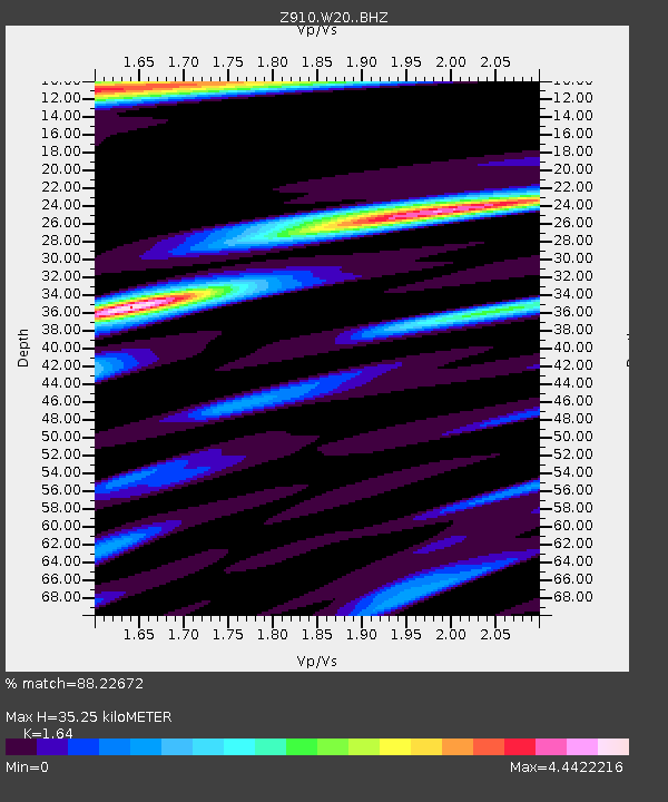
| Estimated Moho Depth: |
35.25 km |
| Estimated Crust Vp/Vs: |
1.64 |
| Assumed Crust Vp: |
6.565 km/s |
| Estimated Crust Vs: |
4.003 km/s |
| Estimated Crust Poisson's Ratio: |
0.20 |
|
| Radial Match: |
88.22672 % |
| Radial Bump: |
400 |
| Transverse Match: |
88.22673 % |
| Transverse Bump: |
400 |
| SOD ConfigId: |
3390531 |
| Insert Time: |
2019-04-10 16:47:10.287 +0000 |
| GWidth: |
2.5 |
| Max Bumps: |
400 |
| Tol: |
0.001 |
|

Signal To Noise
| Channel | StoN | STA | LTA |
| Z9:W20: :BHZ:20140315T23:58:16.819999Z | 5.77573 | 8.562888E-7 | 1.4825638E-7 |
| Z9:W20: :BHN:20140315T23:58:16.819999Z | 2.8270712 | 1.002137E-6 | 3.5447883E-7 |
| $trig.getChannelId() | $trig.getValue() | $trig.getSTA() | $trig.getLTA() |
| Arrivals |
| Ps | 3.7 SECOND |
| PpPs | 13 SECOND |
| PsPs/PpSs | 17 SECOND |


