
Station Z9 W20 - Bledsoe Farm, Montezuma, GA
Network: Z910 - Southeastern Suture of the Appalachian Margin Experiment
Nearby stations (2 deg radius)
| Station | Name | (Lat, Lon) | Start / End | Elevation |
| W20 | Bledsoe Farm, Montezuma, GA | (32.37, -83.92) | 2011-05-11 / 2014-05-13 | 134 m |
| Crust2 Type: | DG,thin Platform 1 km seds. |
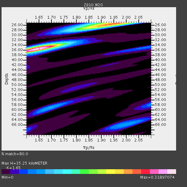
| Thickness Estimate: | 35 km |
| Thickness StdDev: | 0.1 km |
| Vp/Vs Estimate: | 1.65 |
| Vp/Vs StdDev: | 0.00 |
| Vs Estimate: | 3.978 km/s |
| Poisson's Ratio: | 0.21 |
| Peak Value: | 0.32 |
| Assumed Vp: | 6.565 km/s |
| Ps Weight: | 0.33333334 |
| PpPs Weight: | 0.33333334 |
| PsPs Weight: | 0.33333328 |
| Residual Complexity: | 0.674 |
| Nearby stations H: | +- |
| (2.0 deg) Vp/Vs: | +- |
2 with match > 90% ( 9.523809 %) and 4 with match > 80% ( 19.047619 %) out of 21.
Download stack as xyz text file.
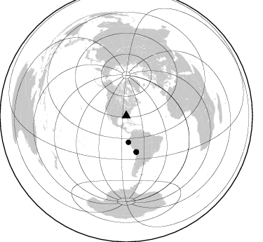
Azimuth Distribution of Events:
Prior Results for this Station
| Study | Thickness | Vp/Vs | Vp | Vs | Poissons Ratio | Extra |
| EARS | 35 km | 1.65 | 6.565 km/s | 3.978 km/s | 0.21 | |
| Crust2.0 | 31 km | 1.78 | 6.565 km/s | 3.684 km/s | 0.27 | DG,thin Platform 1 km seds. |
| Global Maxima | 35 km | 1.65 | 6.565 km/s | 3.978 km/s | 0.21 | amp=0.31897074 |
| Local Maxima 1 | 25 km | 1.95 | 6.565 km/s | 3.362 km/s | 0.32 | amp=0.23520657 |
| Local Maxima 2 | 59 km | 1.69 | 6.565 km/s | 3.879 km/s | 0.23 | amp=0.08073886 |
| Local Maxima 3 | 66 km | 2.00 | 6.565 km/s | 3.286 km/s | 0.33 | amp=0.07305102 |
| Local Maxima 4 | 28 km | 1.83 | 6.565 km/s | 3.582 km/s | 0.29 | amp=0.06773838 |
| Predicted Arrivals for vertical incidence (zero ray parameter) | |
| Ps | 3.49 SECOND |
| PpPs | 14.23 SECOND |
| PsPs/PpSs | 17.72 SECOND |
Events Processed for this Station
Download zip of receiver functions as SAC
Plot maxima for each earthquake.
Events Used in the Stack
(4 events)| Radial Match | Distance | Baz | FERegion | Time | Lat/Lon | Depth | Magnitude |
| 91.795105 | 53.5 deg | 164.395 deg | Near Coast Of Northern Chile | 2014/03/16 21:16:30 GMT | (-19.9, -70.6) | 20 km | 6.7 MWW, 6.7 MWC, 7.0 MI |
| 90.98869 | 53.3 deg | 164.627 deg | Near Coast Of Northern Chile | 2014/03/22 12:59:59 GMT | (-19.8, -70.9) | 20 km | 6.2 MWW, 6.2 MWB, 6.3 MWC, 6.4 MWC |
| 88.22672 | 37.8 deg | 175.189 deg | Near Coast Of Northern Peru | 2014/03/15 23:51:33 GMT | (-5.6, -81.0) | 29 km | 6.3 MWW, 6.2 MWB, 6.3 MWC |
| 81.669174 | 53.9 deg | 164.416 deg | Near Coast Of Northern Chile | 2014/04/03 01:58:31 GMT | (-20.3, -70.6) | 23 km | 6.5 MWW, 6.5 MWB, 6.6 MWC |
Losers
(17 events)| Radial Match | Distance | Baz | FERegion | Time | Lat/Lon | Depth | Magnitude | Reason |
| 96.8621 | 53.2 deg | 164.526 deg | Near Coast Of Northern Chile | 2014/04/01 23:46:46 GMT | (-19.6, -70.8) | 20 km | 8.2 MWW, 8.0 MI, 8.1 MWC | |
| 95.659966 | 54.1 deg | 164.426 deg | Near Coast Of Northern Chile | 2014/04/03 02:43:14 GMT | (-20.5, -70.5) | 31 km | 7.7 MWW, 7.4 MI, 7.7 MWC | |
| 82.19445 | 33.9 deg | 296.293 deg | Off Coast Of Northern California | 2014/03/10 05:18:13 GMT | (40.8, -125.1) | 17 km | 6.8 MW, 6.8 MWR, 6.9 MWW, 6.9 MWB, 7.0 MI, 7.0 MWC | |
| 75.97734 | 53.2 deg | 163.738 deg | Near Coast Of Northern Chile | 2014/04/01 23:59:57 GMT | (-19.5, -70.2) | 22 km | 5.8 MB | |
| 73.09484 | 54.2 deg | 164.727 deg | Near Coast Of Northern Chile | 2014/04/04 01:37:51 GMT | (-20.6, -70.7) | 20 km | 6.1 MWP, 6.1 MWB, 6.1 MWW, 6.3 MWC | |
| 72.47611 | 53.3 deg | 164.549 deg | Near Coast Of Northern Chile | 2014/03/23 18:20:03 GMT | (-19.7, -70.8) | 35 km | 6.0 MB, 6.2 MWB, 6.2 MWW, 6.3 MWC | |
| 61.675232 | 46.8 deg | 169.841 deg | Near Coast Of Peru | 2014/03/15 08:59:21 GMT | (-14.1, -76.3) | 20 km | 6.1 MWW, 6.0 MWB, 6.2 MWC | |
| 61.572197 | 95.5 deg | 34.41 deg | Eastern Caucasus | 2014/02/10 12:06:46 GMT | (40.3, 48.8) | 63 km | 5.5 MW | |
| 60.121 | 67.7 deg | 169.217 deg | Near Coast Of Central Chile | 2014/03/15 14:46:28 GMT | (-34.7, -71.8) | 45 km | 5.5 MB, 5.1 MWW | |
| 54.02393 | 54.1 deg | 164.673 deg | Near Coast Of Northern Chile | 2014/04/03 09:23:21 GMT | (-20.6, -70.7) | 15 km | 5.6 MB, 5.3 MWR | |
| 50.988045 | 54.8 deg | 156.704 deg | Southern Bolivia | 2014/01/27 16:42:37 GMT | (-19.3, -63.9) | 600 km | 5.6 MWB | |
| 50.943882 | 57.8 deg | 164.065 deg | Northern Chile | 2014/03/20 18:41:32 GMT | (-24.0, -69.2) | 96 km | 5.1 MW | |
| 50.567944 | 68.6 deg | 317.683 deg | Andreanof Islands, Aleutian Is. | 2014/01/16 07:33:09 GMT | (51.2, -179.2) | 27 km | 5.5 MWB, 5.2 ML, 5.5 ML, 5.6 MWC | |
| 47.07631 | 46.9 deg | 168.928 deg | Near Coast Of Peru | 2014/02/18 23:35:58 GMT | (-14.2, -75.6) | 57 km | 6.0 MWB, 5.9 MWW, 5.9 MWC, 6.0 MWC | |
| 45.950554 | 86.2 deg | 325.308 deg | Kuril Islands | 2014/01/15 10:25:14 GMT | (47.1, 152.3) | 107 km | 4.5 mb | |
| 45.54165 | 63.5 deg | 318.28 deg | Fox Islands, Aleutian Islands | 2014/02/26 21:13:40 GMT | (53.6, -171.8) | 265 km | 6.1 MWW, 5.9 MI, 5.9 ML, 6.1 MWC, 6.1 MWB, 6.2 MWC | |
| 40.482357 | 36.7 deg | 78.255 deg | Northern Mid-Atlantic Ridge | 2014/03/01 02:16:39 GMT | (32.2, -40.3) | 14 km | 5.2 MW |

