You are here: Home > Network List > IC - New China Digital Seismograph Network Stations List
> Station HIA Hailar, Neimenggu Autonomous Region, China > Earthquake Result Viewer
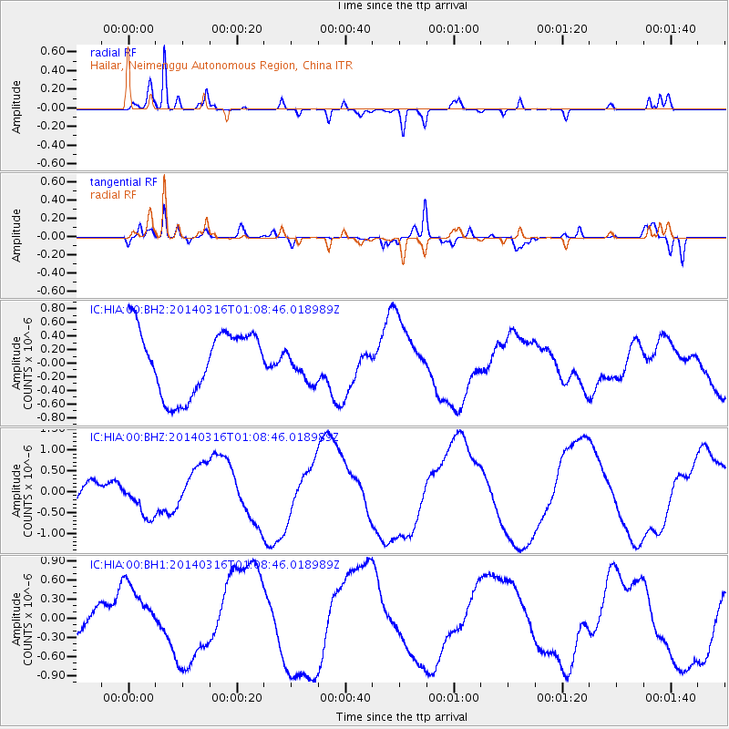
HIA Hailar, Neimenggu Autonomous Region, China - Earthquake Result Viewer
*The percent match for this event was below the threshold and hence no stack was calculated.
| Earthquake location: |
Banda Sea |
| Earthquake latitude/longitude: |
-7.5/126.0 |
| Earthquake time(UTC): |
2014/03/16 (075) 01:00:15 GMT |
| Earthquake Depth: |
433 km |
| Earthquake Magnitude: |
5.0 mb |
| Earthquake Catalog/Contributor: |
ISC/ISC |
|
| Network: |
IC New China Digital Seismograph Network |
| Station: |
HIA Hailar, Neimenggu Autonomous Region, China |
| Lat/Lon: |
49.27 N/119.74 E |
| Elevation: |
620 m |
|
| Distance: |
56.8 deg |
| Az: |
355.111 deg |
| Baz: |
172.587 deg |
| Ray Param: |
$rayparam |
*The percent match for this event was below the threshold and hence was not used in the summary stack. |
|
| Radial Match: |
93.30833 % |
| Radial Bump: |
375 |
| Transverse Match: |
84.52654 % |
| Transverse Bump: |
400 |
| SOD ConfigId: |
3390531 |
| Insert Time: |
2019-04-10 16:48:22.024 +0000 |
| GWidth: |
2.5 |
| Max Bumps: |
400 |
| Tol: |
0.001 |
|
Signal To Noise
| Channel | StoN | STA | LTA |
| IC:HIA:00:BHZ:20140316T01:08:46.018989Z | 2.6677988 | 4.3757657E-7 | 1.6402159E-7 |
| IC:HIA:00:BH1:20140316T01:08:46.018989Z | 1.3501674 | 4.319989E-7 | 3.199595E-7 |
| IC:HIA:00:BH2:20140316T01:08:46.018989Z | 0.5180548 | 2.4550388E-7 | 4.738956E-7 |
| Arrivals |
| Ps | |
| PpPs | |
| PsPs/PpSs | |


