You are here: Home > Network List > Z910 - Southeastern Suture of the Appalachian Margin Experiment Stations List
> Station D12 Alewine Property, Royston, GA > Earthquake Result Viewer
D12 Alewine Property, Royston, GA - Earthquake Result Viewer
| Earthquake location: |
Near Coast Of Northern Chile |
| Earthquake latitude/longitude: |
-19.9/-70.6 |
| Earthquake time(UTC): |
2014/03/16 (075) 21:16:30 GMT |
| Earthquake Depth: |
20 km |
| Earthquake Magnitude: |
6.7 MWW, 6.7 MWC, 7.0 MI |
| Earthquake Catalog/Contributor: |
NEIC PDE/NEIC COMCAT |
|
| Network: |
Z9 Southeastern Suture of the Appalachian Margin Experiment |
| Station: |
D12 Alewine Property, Royston, GA |
| Lat/Lon: |
34.25 N/83.03 W |
| Elevation: |
247 m |
|
| Distance: |
55.1 deg |
| Az: |
347.476 deg |
| Baz: |
165.741 deg |
| Ray Param: |
0.06495948 |
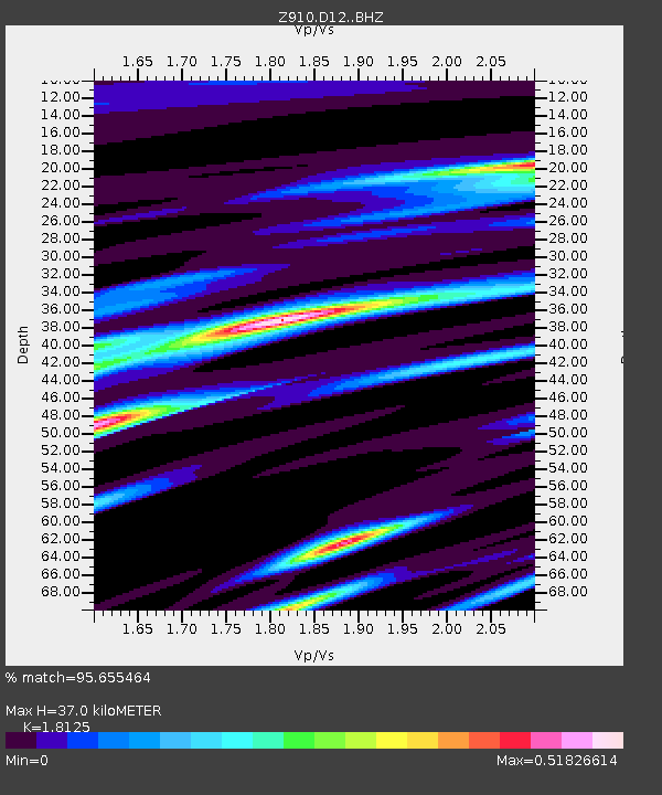
| Estimated Moho Depth: |
37.0 km |
| Estimated Crust Vp/Vs: |
1.81 |
| Assumed Crust Vp: |
6.35 km/s |
| Estimated Crust Vs: |
3.503 km/s |
| Estimated Crust Poisson's Ratio: |
0.28 |
|
| Radial Match: |
95.655464 % |
| Radial Bump: |
281 |
| Transverse Match: |
67.530594 % |
| Transverse Bump: |
400 |
| SOD ConfigId: |
3390531 |
| Insert Time: |
2019-04-10 17:00:48.801 +0000 |
| GWidth: |
2.5 |
| Max Bumps: |
400 |
| Tol: |
0.001 |
|

Signal To Noise
| Channel | StoN | STA | LTA |
| Z9:D12: :BHZ:20140316T21:25:30.420024Z | 18.301401 | 3.7290115E-6 | 2.0375552E-7 |
| Z9:D12: :BHN:20140316T21:25:30.420024Z | 13.397817 | 1.8949593E-6 | 1.4143792E-7 |
| Z9:D12: :BHE:20140316T21:25:30.420024Z | 5.1416893 | 6.7247936E-7 | 1.3078957E-7 |
| Arrivals |
| Ps | 5.0 SECOND |
| PpPs | 16 SECOND |
| PsPs/PpSs | 21 SECOND |


