You are here: Home > Network List > Z910 - Southeastern Suture of the Appalachian Margin Experiment Stations List
> Station E02 St. Johns River Water District, Palatka, FL > Earthquake Result Viewer
E02 St. Johns River Water District, Palatka, FL - Earthquake Result Viewer
| Earthquake location: |
Near Coast Of Northern Chile |
| Earthquake latitude/longitude: |
-19.9/-70.6 |
| Earthquake time(UTC): |
2014/03/16 (075) 21:16:30 GMT |
| Earthquake Depth: |
20 km |
| Earthquake Magnitude: |
6.7 MWW, 6.7 MWC, 7.0 MI |
| Earthquake Catalog/Contributor: |
NEIC PDE/NEIC COMCAT |
|
| Network: |
Z9 Southeastern Suture of the Appalachian Margin Experiment |
| Station: |
E02 St. Johns River Water District, Palatka, FL |
| Lat/Lon: |
29.44 N/82.07 W |
| Elevation: |
21 m |
|
| Distance: |
50.3 deg |
| Az: |
347.007 deg |
| Baz: |
165.965 deg |
| Ray Param: |
0.06812067 |
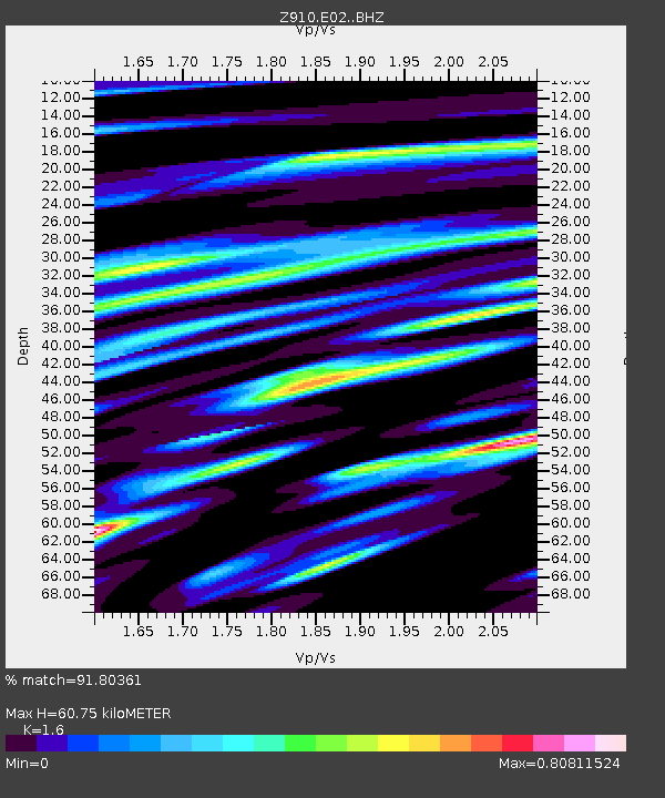
| Estimated Moho Depth: |
60.75 km |
| Estimated Crust Vp/Vs: |
1.60 |
| Assumed Crust Vp: |
5.989 km/s |
| Estimated Crust Vs: |
3.743 km/s |
| Estimated Crust Poisson's Ratio: |
0.18 |
|
| Radial Match: |
91.80361 % |
| Radial Bump: |
400 |
| Transverse Match: |
69.126854 % |
| Transverse Bump: |
400 |
| SOD ConfigId: |
3390531 |
| Insert Time: |
2019-04-10 17:00:56.073 +0000 |
| GWidth: |
2.5 |
| Max Bumps: |
400 |
| Tol: |
0.001 |
|

Signal To Noise
| Channel | StoN | STA | LTA |
| Z9:E02: :BHZ:20140316T21:24:54.639995Z | 14.387837 | 5.742345E-6 | 3.9911103E-7 |
| Z9:E02: :BHN:20140316T21:24:54.639995Z | 8.9228 | 2.9798912E-6 | 3.339637E-7 |
| Z9:E02: :BHE:20140316T21:24:54.639995Z | 2.8066628 | 9.2514296E-7 | 3.2962384E-7 |
| Arrivals |
| Ps | 6.4 SECOND |
| PpPs | 25 SECOND |
| PsPs/PpSs | 31 SECOND |


