
Station Z9 E02 - St. Johns River Water District, Palatka, FL
Network: Z910 - Southeastern Suture of the Appalachian Margin Experiment
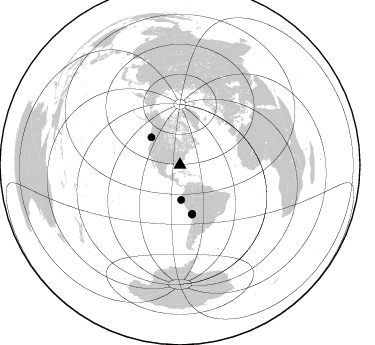
Nearby stations (2 deg radius)
| Station | Name | (Lat, Lon) | Start / End | Elevation |
| E02 | St. Johns River Water District, Palatka, FL | (29.44, -82.07) | 2012-05-15 / 2014-05-15 | 21 m |
| Crust2 Type: | C4,continental shelf, 3.5 km seds. |
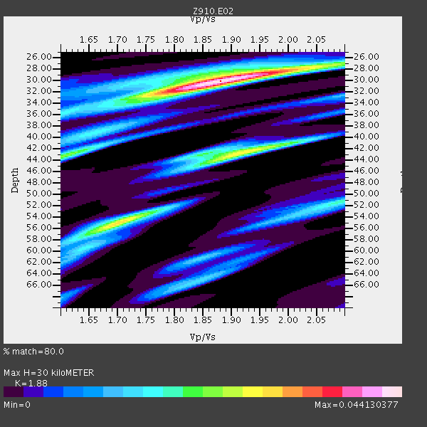
| Thickness Estimate: | 30 km |
| Thickness StdDev: | 7.6 km |
| Vp/Vs Estimate: | 1.88 |
| Vp/Vs StdDev: | 0.10 |
| Vs Estimate: | 3.186 km/s |
| Poisson's Ratio: | 0.30 |
| Peak Value: | 0.04 |
| Assumed Vp: | 5.989 km/s |
| Ps Weight: | 0.33333334 |
| PpPs Weight: | 0.33333334 |
| PsPs Weight: | 0.33333328 |
| Residual Complexity: | 0.708 |
| Nearby stations H: | +- |
| (2.0 deg) Vp/Vs: | +- |
2 with match > 90% ( 9.523809 %) and 5 with match > 80% ( 23.809525 %) out of 21.
Download stack as xyz text file.
Azimuth Distribution of Events:
Prior Results for this Station
| Study | Thickness | Vp/Vs | Vp | Vs | Poissons Ratio | Extra |
| EARS | 30 km | 1.88 | 5.989 km/s | 3.186 km/s | 0.30 | |
| Crust2.0 | 32 km | 1.81 | 5.989 km/s | 3.317 km/s | 0.28 | C4,continental shelf, 3.5 km seds. |
| Global Maxima | 30 km | 1.88 | 5.989 km/s | 3.186 km/s | 0.30 | amp=0.044130377 |
| Local Maxima 1 | 55 km | 1.70 | 5.989 km/s | 3.523 km/s | 0.24 | amp=0.029937051 |
| Local Maxima 2 | 43 km | 1.91 | 5.989 km/s | 3.132 km/s | 0.31 | amp=0.02716262 |
| Local Maxima 3 | 43 km | 1.61 | 5.989 km/s | 3.72 km/s | 0.19 | amp=0.02308306 |
| Local Maxima 4 | 51 km | 2.10 | 5.989 km/s | 2.855 km/s | 0.35 | amp=0.019443847 |
| Predicted Arrivals for vertical incidence (zero ray parameter) | |
| Ps | 4.41 SECOND |
| PpPs | 14.43 SECOND |
| PsPs/PpSs | 18.83 SECOND |
Events Processed for this Station
Download zip of receiver functions as SAC
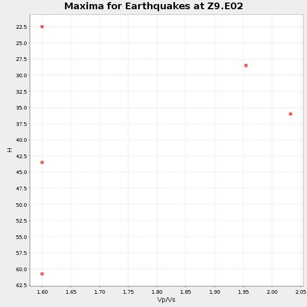
Plot maxima for each earthquake.
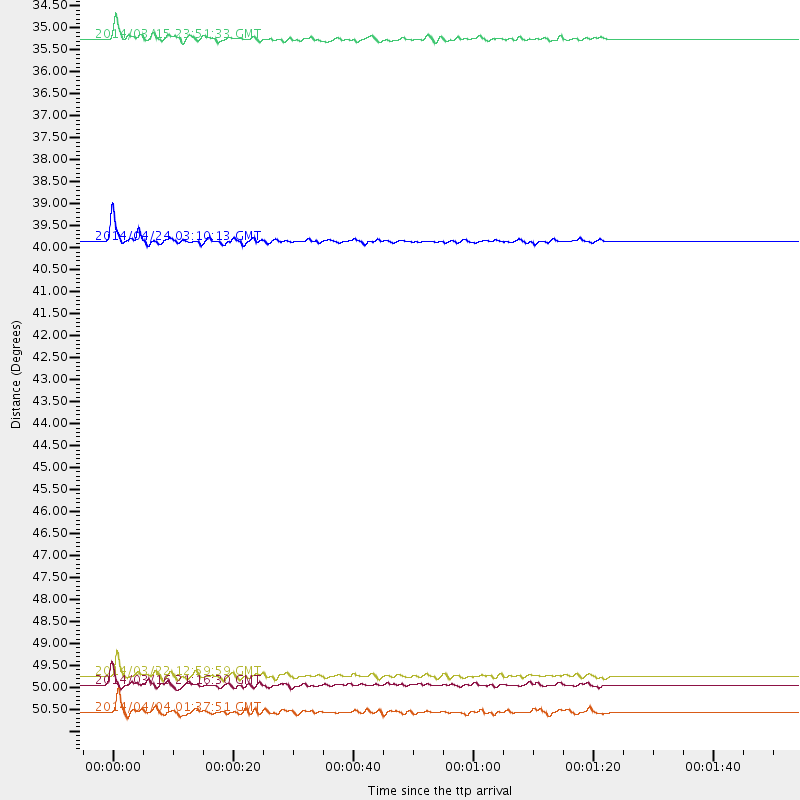
Events Used in the Stack
(5 events)| Radial Match | Distance | Baz | FERegion | Time | Lat/Lon | Depth | Magnitude |
| 93.6761 | 39.7 deg | 313.843 deg | Vancouver Island, Canada Region | 2014/04/24 03:10:13 GMT | (49.8, -127.4) | 11 km | 6.7 MWP, 6.7 MI |
| 91.80361 | 50.3 deg | 165.965 deg | Near Coast Of Northern Chile | 2014/03/16 21:16:30 GMT | (-19.9, -70.6) | 20 km | 6.7 MWW, 6.7 MWC, 7.0 MI |
| 89.759445 | 50.1 deg | 166.212 deg | Near Coast Of Northern Chile | 2014/03/22 12:59:59 GMT | (-19.8, -70.9) | 20 km | 6.2 MWW, 6.2 MWB, 6.3 MWC, 6.4 MWC |
| 89.16504 | 51.0 deg | 166.296 deg | Near Coast Of Northern Chile | 2014/04/04 01:37:51 GMT | (-20.6, -70.7) | 20 km | 6.1 MWP, 6.1 MWB, 6.1 MWW, 6.3 MWC |
| 80.23388 | 34.8 deg | 178.064 deg | Near Coast Of Northern Peru | 2014/03/15 23:51:33 GMT | (-5.6, -81.0) | 29 km | 6.3 MWW, 6.2 MWB, 6.3 MWC |
Losers
(16 events)| Radial Match | Distance | Baz | FERegion | Time | Lat/Lon | Depth | Magnitude | Reason |
| 98.8053 | 50.0 deg | 166.109 deg | Near Coast Of Northern Chile | 2014/04/01 23:46:46 GMT | (-19.6, -70.8) | 20 km | 8.2 MWW, 8.0 MI, 8.1 MWC | |
| 94.64388 | 50.9 deg | 165.983 deg | Near Coast Of Northern Chile | 2014/04/03 02:43:14 GMT | (-20.5, -70.5) | 31 km | 7.7 MWW, 7.4 MI, 7.7 MWC | |
| 93.417534 | 36.7 deg | 299.817 deg | Off Coast Of Northern California | 2014/03/10 05:18:13 GMT | (40.8, -125.1) | 17 km | 6.8 MW, 6.8 MWR, 6.9 MWW, 6.9 MWB, 7.0 MI, 7.0 MWC | |
| 92.92727 | 51.0 deg | 166.293 deg | Near Coast Of Northern Chile | 2014/04/03 03:11:14 GMT | (-20.6, -70.7) | 10 km | 5.8 MB | |
| 81.12886 | 50.5 deg | 165.883 deg | Near Coast Of Northern Chile | 2014/04/05 05:44:57 GMT | (-20.1, -70.5) | 39 km | 5.3 MW | |
| 78.699066 | 50.7 deg | 165.979 deg | Near Coast Of Northern Chile | 2014/04/03 01:58:31 GMT | (-20.3, -70.6) | 23 km | 6.5 MWW, 6.5 MWB, 6.6 MWC | |
| 70.08084 | 43.8 deg | 170.92 deg | Near Coast Of Peru | 2014/02/18 23:35:58 GMT | (-14.2, -75.6) | 57 km | 6.0 MWB, 5.9 MWW, 5.9 MWC, 6.0 MWC | |
| 69.38385 | 50.1 deg | 166.131 deg | Near Coast Of Northern Chile | 2014/03/23 18:20:03 GMT | (-19.7, -70.8) | 35 km | 6.0 MB, 6.2 MWB, 6.2 MWW, 6.3 MWC | |
| 69.34195 | 86.1 deg | 325.84 deg | Kuril Islands | 2014/01/19 00:52:35 GMT | (49.1, 156.4) | 34 km | 4.9 MW | |
| 66.20065 | 50.2 deg | 166.236 deg | Near Coast Of Northern Chile | 2014/04/02 00:03:12 GMT | (-19.8, -70.9) | 10 km | 5.8 MB | |
| 65.74007 | 50.5 deg | 166.296 deg | Near Coast Of Northern Chile | 2014/04/02 04:46:18 GMT | (-20.2, -70.9) | 10 km | 5.8 MB | |
| 64.254456 | 55.1 deg | 324.835 deg | Southern Alaska | 2014/05/10 14:16:08 GMT | (60.0, -152.2) | 96 km | 5.8 ML, 5.5 MI, 5.7 MWP | |
| 63.92829 | 43.6 deg | 171.89 deg | Near Coast Of Peru | 2014/03/15 08:59:21 GMT | (-14.1, -76.3) | 20 km | 6.1 MWW, 6.0 MWB, 6.2 MWC | |
| 58.80426 | 50.9 deg | 166.241 deg | Near Coast Of Northern Chile | 2014/04/03 09:23:21 GMT | (-20.6, -70.7) | 15 km | 5.6 MB, 5.3 MWR | |
| 57.883377 | 66.7 deg | 319.559 deg | Fox Islands, Aleutian Islands | 2014/02/26 21:13:40 GMT | (53.6, -171.8) | 265 km | 6.1 MWW, 5.9 MI, 5.9 ML, 6.1 MWC, 6.1 MWB, 6.2 MWC | |
| 42.46855 | 84.0 deg | 50.54 deg | Southern Greece | 2014/04/04 20:08:07 GMT | (37.2, 23.8) | 107 km | 5.5 MWB, 5.5 MWR, 5.6 MWC, 5.6 MWW |

