You are here: Home > Network List > Z910 - Southeastern Suture of the Appalachian Margin Experiment Stations List
> Station W20 Bledsoe Farm, Montezuma, GA > Earthquake Result Viewer
W20 Bledsoe Farm, Montezuma, GA - Earthquake Result Viewer
| Earthquake location: |
Near Coast Of Northern Chile |
| Earthquake latitude/longitude: |
-19.9/-70.6 |
| Earthquake time(UTC): |
2014/03/16 (075) 21:16:30 GMT |
| Earthquake Depth: |
20 km |
| Earthquake Magnitude: |
6.7 MWW, 6.7 MWC, 7.0 MI |
| Earthquake Catalog/Contributor: |
NEIC PDE/NEIC COMCAT |
|
| Network: |
Z9 Southeastern Suture of the Appalachian Margin Experiment |
| Station: |
W20 Bledsoe Farm, Montezuma, GA |
| Lat/Lon: |
32.37 N/83.92 W |
| Elevation: |
134 m |
|
| Distance: |
53.5 deg |
| Az: |
345.998 deg |
| Baz: |
164.395 deg |
| Ray Param: |
0.066013545 |
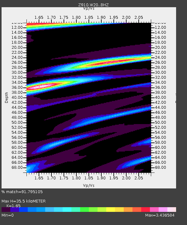
| Estimated Moho Depth: |
35.5 km |
| Estimated Crust Vp/Vs: |
1.65 |
| Assumed Crust Vp: |
6.565 km/s |
| Estimated Crust Vs: |
3.978 km/s |
| Estimated Crust Poisson's Ratio: |
0.21 |
|
| Radial Match: |
91.795105 % |
| Radial Bump: |
400 |
| Transverse Match: |
91.7951 % |
| Transverse Bump: |
400 |
| SOD ConfigId: |
3390531 |
| Insert Time: |
2019-04-10 17:01:22.420 +0000 |
| GWidth: |
2.5 |
| Max Bumps: |
400 |
| Tol: |
0.001 |
|

Signal To Noise
| Channel | StoN | STA | LTA |
| Z9:W20: :BHZ:20140316T21:25:18.639995Z | 19.154383 | 5.6386384E-6 | 2.9437848E-7 |
| Z9:W20: :BHN:20140316T21:25:18.639995Z | 6.1063466 | 4.0178998E-6 | 6.579875E-7 |
| $trig.getChannelId() | $trig.getValue() | $trig.getSTA() | $trig.getLTA() |
| Arrivals |
| Ps | 3.7 SECOND |
| PpPs | 13 SECOND |
| PsPs/PpSs | 17 SECOND |


