You are here: Home > Network List > Z910 - Southeastern Suture of the Appalachian Margin Experiment Stations List
> Station W21 Melatchee Woodlands, Marshallville, GA > Earthquake Result Viewer
W21 Melatchee Woodlands, Marshallville, GA - Earthquake Result Viewer
| Earthquake location: |
Near Coast Of Northern Chile |
| Earthquake latitude/longitude: |
-19.9/-70.6 |
| Earthquake time(UTC): |
2014/03/16 (075) 21:16:30 GMT |
| Earthquake Depth: |
20 km |
| Earthquake Magnitude: |
6.7 MWW, 6.7 MWC, 7.0 MI |
| Earthquake Catalog/Contributor: |
NEIC PDE/NEIC COMCAT |
|
| Network: |
Z9 Southeastern Suture of the Appalachian Margin Experiment |
| Station: |
W21 Melatchee Woodlands, Marshallville, GA |
| Lat/Lon: |
32.40 N/83.86 W |
| Elevation: |
131 m |
|
| Distance: |
53.6 deg |
| Az: |
346.073 deg |
| Baz: |
164.472 deg |
| Ray Param: |
0.0659987 |
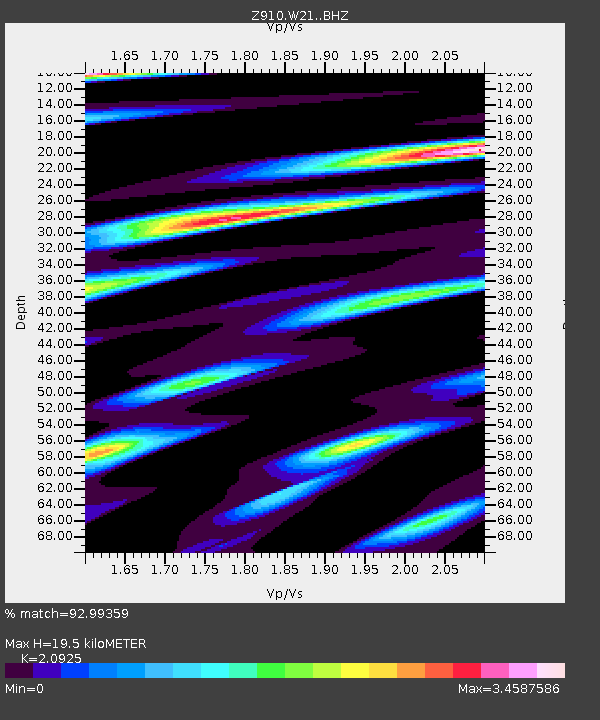
| Estimated Moho Depth: |
19.5 km |
| Estimated Crust Vp/Vs: |
2.09 |
| Assumed Crust Vp: |
6.565 km/s |
| Estimated Crust Vs: |
3.137 km/s |
| Estimated Crust Poisson's Ratio: |
0.35 |
|
| Radial Match: |
92.99359 % |
| Radial Bump: |
393 |
| Transverse Match: |
73.16777 % |
| Transverse Bump: |
400 |
| SOD ConfigId: |
3390531 |
| Insert Time: |
2019-04-10 17:01:24.534 +0000 |
| GWidth: |
2.5 |
| Max Bumps: |
400 |
| Tol: |
0.001 |
|

Signal To Noise
| Channel | StoN | STA | LTA |
| Z9:W21: :BHZ:20140316T21:25:18.819988Z | 27.284184 | 5.2770965E-6 | 1.934123E-7 |
| Z9:W21: :BHN:20140316T21:25:18.819988Z | 6.6078477 | 3.053633E-6 | 4.621222E-7 |
| Z9:W21: :BHE:20140316T21:25:18.819988Z | 1.9770122 | 1.2256755E-6 | 6.199636E-7 |
| Arrivals |
| Ps | 3.4 SECOND |
| PpPs | 8.8 SECOND |
| PsPs/PpSs | 12 SECOND |


