
Station Z9 W21 - Melatchee Woodlands, Marshallville, GA
Network: Z910 - Southeastern Suture of the Appalachian Margin Experiment
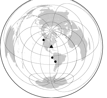
Nearby stations (2 deg radius)
| Station | Name | (Lat, Lon) | Start / End | Elevation |
| W21 | Melatchee Woodlands, Marshallville, GA | (32.40, -83.86) | 2011-05-11 / 2014-05-13 | 131 m |
| Crust2 Type: | DG,thin Platform 1 km seds. |
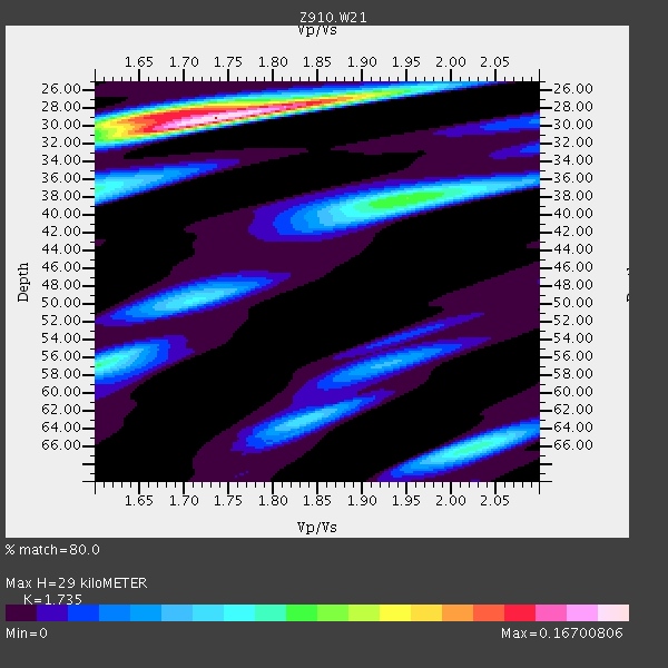
| Thickness Estimate: | 29 km |
| Thickness StdDev: | 6.3 km |
| Vp/Vs Estimate: | 1.74 |
| Vp/Vs StdDev: | 0.07 |
| Vs Estimate: | 3.784 km/s |
| Poisson's Ratio: | 0.25 |
| Peak Value: | 0.17 |
| Assumed Vp: | 6.565 km/s |
| Ps Weight: | 0.33333334 |
| PpPs Weight: | 0.33333334 |
| PsPs Weight: | 0.33333328 |
| Residual Complexity: | 0.633 |
| Nearby stations H: | +- |
| (2.0 deg) Vp/Vs: | +- |
2 with match > 90% ( 7.142857 %) and 6 with match > 80% ( 21.428572 %) out of 28.
Download stack as xyz text file.
Azimuth Distribution of Events:
Prior Results for this Station
| Study | Thickness | Vp/Vs | Vp | Vs | Poissons Ratio | Extra |
| EARS | 29 km | 1.74 | 6.565 km/s | 3.784 km/s | 0.25 | |
| Crust2.0 | 31 km | 1.78 | 6.565 km/s | 3.684 km/s | 0.27 | DG,thin Platform 1 km seds. |
| Global Maxima | 29 km | 1.74 | 6.565 km/s | 3.784 km/s | 0.25 | amp=0.16700806 |
| Local Maxima 1 | 28 km | 1.68 | 6.565 km/s | 3.913 km/s | 0.22 | amp=0.09556524 |
| Local Maxima 2 | 38 km | 1.95 | 6.565 km/s | 3.366 km/s | 0.32 | amp=0.08351455 |
| Local Maxima 3 | 57 km | 1.61 | 6.565 km/s | 4.09 km/s | 0.18 | amp=0.07508471 |
| Local Maxima 4 | 66 km | 2.03 | 6.565 km/s | 3.242 km/s | 0.34 | amp=0.072332636 |
| Predicted Arrivals for vertical incidence (zero ray parameter) | |
| Ps | 3.25 SECOND |
| PpPs | 12.08 SECOND |
| PsPs/PpSs | 15.33 SECOND |
Events Processed for this Station
Download zip of receiver functions as SAC
Plot maxima for each earthquake.
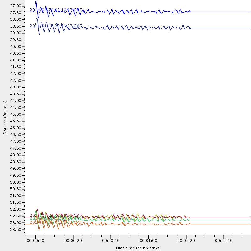
Events Used in the Stack
(6 events)| Radial Match | Distance | Baz | FERegion | Time | Lat/Lon | Depth | Magnitude |
| 92.99359 | 53.6 deg | 164.472 deg | Near Coast Of Northern Chile | 2014/03/16 21:16:30 GMT | (-19.9, -70.6) | 20 km | 6.7 MWW, 6.7 MWC, 7.0 MI |
| 91.43377 | 36.6 deg | 311.49 deg | Vancouver Island, Canada Region | 2014/04/24 03:10:13 GMT | (49.8, -127.4) | 11 km | 6.7 MWP, 6.7 MI |
| 88.6262 | 53.3 deg | 164.704 deg | Near Coast Of Northern Chile | 2014/03/22 12:59:59 GMT | (-19.8, -70.9) | 20 km | 6.2 MWW, 6.2 MWB, 6.3 MWC, 6.4 MWC |
| 87.51363 | 37.9 deg | 175.292 deg | Near Coast Of Northern Peru | 2014/03/15 23:51:33 GMT | (-5.6, -81.0) | 29 km | 6.3 MWW, 6.2 MWB, 6.3 MWC |
| 85.32596 | 53.9 deg | 164.493 deg | Near Coast Of Northern Chile | 2014/04/03 01:58:31 GMT | (-20.3, -70.6) | 23 km | 6.5 MWW, 6.5 MWB, 6.6 MWC |
| 83.51962 | 53.3 deg | 164.627 deg | Near Coast Of Northern Chile | 2014/03/23 18:20:03 GMT | (-19.7, -70.8) | 35 km | 6.0 MB, 6.2 MWB, 6.2 MWW, 6.3 MWC |
Losers
(22 events)| Radial Match | Distance | Baz | FERegion | Time | Lat/Lon | Depth | Magnitude | Reason |
| 95.224686 | 53.2 deg | 164.604 deg | Near Coast Of Northern Chile | 2014/04/01 23:46:46 GMT | (-19.6, -70.8) | 20 km | 8.2 MWW, 8.0 MI, 8.1 MWC | |
| 93.09601 | 54.2 deg | 164.502 deg | Near Coast Of Northern Chile | 2014/04/03 02:43:14 GMT | (-20.5, -70.5) | 31 km | 7.7 MWW, 7.4 MI, 7.7 MWC | |
| 92.819695 | 54.2 deg | 164.803 deg | Near Coast Of Northern Chile | 2014/04/04 01:37:51 GMT | (-20.6, -70.7) | 20 km | 6.1 MWP, 6.1 MWB, 6.1 MWW, 6.3 MWC | |
| 89.377655 | 33.9 deg | 296.242 deg | Off Coast Of Northern California | 2014/03/10 05:18:13 GMT | (40.8, -125.1) | 17 km | 6.8 MW, 6.8 MWR, 6.9 MWW, 6.9 MWB, 7.0 MI, 7.0 MWC | |
| 82.338295 | 53.2 deg | 163.815 deg | Near Coast Of Northern Chile | 2014/04/01 23:59:57 GMT | (-19.5, -70.2) | 22 km | 5.8 MB | |
| 73.372086 | 51.8 deg | 323.564 deg | Southern Alaska | 2014/05/10 14:16:08 GMT | (60.0, -152.2) | 96 km | 5.8 ML, 5.5 MI, 5.7 MWP | |
| 70.50099 | 56.2 deg | 333.24 deg | Northern Alaska | 2014/04/18 18:56:47 GMT | (67.7, -162.5) | 17 km | 5.7 MW | |
| 66.312355 | 56.1 deg | 333.141 deg | Northern Alaska | 2014/05/03 08:57:12 GMT | (67.6, -162.2) | 0.9 km | 5.5 MB | |
| 64.70536 | 65.9 deg | 168.683 deg | Near Coast Of Central Chile | 2014/04/05 02:22:38 GMT | (-32.8, -71.6) | 40 km | 5.6 MWC, 5.6 MWC | |
| 64.5749 | 68.6 deg | 317.691 deg | Andreanof Islands, Aleutian Is. | 2014/01/16 07:33:09 GMT | (51.2, -179.2) | 27 km | 5.5 MWB, 5.2 ML, 5.5 ML, 5.6 MWC | |
| 64.227165 | 47.0 deg | 169.014 deg | Near Coast Of Peru | 2014/02/18 23:35:58 GMT | (-14.2, -75.6) | 57 km | 6.0 MWB, 5.9 MWW, 5.9 MWC, 6.0 MWC | |
| 60.160038 | 46.8 deg | 169.928 deg | Near Coast Of Peru | 2014/03/15 08:59:21 GMT | (-14.1, -76.3) | 20 km | 6.1 MWW, 6.0 MWB, 6.2 MWC | |
| 59.774284 | 52.5 deg | 162.59 deg | Northern Chile | 2014/01/29 10:01:50 GMT | (-18.5, -69.4) | 120 km | 5.6 MWW, 5.6 MWB, 5.7 MWC | |
| 59.5518 | 54.8 deg | 156.78 deg | Southern Bolivia | 2014/01/27 16:42:37 GMT | (-19.3, -63.9) | 600 km | 5.6 MWB | |
| 58.859215 | 52.9 deg | 164.448 deg | Near Coast Of Northern Chile | 2014/04/02 02:52:26 GMT | (-19.3, -70.8) | 17 km | 4.9 mb | |
| 56.39711 | 63.5 deg | 318.281 deg | Fox Islands, Aleutian Islands | 2014/02/26 21:13:40 GMT | (53.6, -171.8) | 265 km | 6.1 MWW, 5.9 MI, 5.9 ML, 6.1 MWC, 6.1 MWB, 6.2 MWC | |
| 56.20112 | 53.7 deg | 164.812 deg | Near Coast Of Northern Chile | 2014/04/07 13:43:20 GMT | (-20.2, -70.9) | 7.9 km | 5.8 MWB, 5.7 MWW, 5.7 MWC | |
| 54.633522 | 54.1 deg | 164.748 deg | Near Coast Of Northern Chile | 2014/04/03 09:23:21 GMT | (-20.6, -70.7) | 15 km | 5.6 MB, 5.3 MWR | |
| 50.648506 | 53.3 deg | 164.837 deg | Near Coast Of Northern Chile | 2014/03/22 22:14:57 GMT | (-19.7, -71.0) | 19 km | 5.1 MW | |
| 48.112434 | 83.3 deg | 49.986 deg | Southern Greece | 2014/04/04 20:08:07 GMT | (37.2, 23.8) | 107 km | 5.5 MWB, 5.5 MWR, 5.6 MWC, 5.6 MWW | |
| 43.41548 | 86.4 deg | 199.885 deg | Southern East Pacific Rise | 2014/05/12 20:07:51 GMT | (-49.7, -115.3) | 10 km | 5.4 MW | |
| 40.6409 | 86.2 deg | 199.507 deg | Southern East Pacific Rise | 2014/04/09 08:28:48 GMT | (-49.7, -114.7) | 10 km | 5.6 Mwc |

