You are here: Home > Network List > Z910 - Southeastern Suture of the Appalachian Margin Experiment Stations List
> Station W31 Fort Yargo State Park, Winder, GA > Earthquake Result Viewer
W31 Fort Yargo State Park, Winder, GA - Earthquake Result Viewer
| Earthquake location: |
Near Coast Of Northern Chile |
| Earthquake latitude/longitude: |
-19.9/-70.6 |
| Earthquake time(UTC): |
2014/03/16 (075) 21:16:30 GMT |
| Earthquake Depth: |
20 km |
| Earthquake Magnitude: |
6.7 MWW, 6.7 MWC, 7.0 MI |
| Earthquake Catalog/Contributor: |
NEIC PDE/NEIC COMCAT |
|
| Network: |
Z9 Southeastern Suture of the Appalachian Margin Experiment |
| Station: |
W31 Fort Yargo State Park, Winder, GA |
| Lat/Lon: |
33.97 N/83.74 W |
| Elevation: |
292 m |
|
| Distance: |
55.0 deg |
| Az: |
346.701 deg |
| Baz: |
164.904 deg |
| Ray Param: |
0.06503708 |
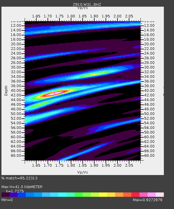
| Estimated Moho Depth: |
41.0 km |
| Estimated Crust Vp/Vs: |
1.73 |
| Assumed Crust Vp: |
6.565 km/s |
| Estimated Crust Vs: |
3.8 km/s |
| Estimated Crust Poisson's Ratio: |
0.25 |
|
| Radial Match: |
95.22313 % |
| Radial Bump: |
272 |
| Transverse Match: |
77.18221 % |
| Transverse Bump: |
400 |
| SOD ConfigId: |
3390531 |
| Insert Time: |
2019-04-10 17:01:28.146 +0000 |
| GWidth: |
2.5 |
| Max Bumps: |
400 |
| Tol: |
0.001 |
|

Signal To Noise
| Channel | StoN | STA | LTA |
| Z9:W31: :BHZ:20140316T21:25:29.579998Z | 26.109604 | 3.7534394E-6 | 1.4375705E-7 |
| Z9:W31: :BHN:20140316T21:25:29.579998Z | 15.183351 | 2.0010377E-6 | 1.3179158E-7 |
| Z9:W31: :BHE:20140316T21:25:29.579998Z | 4.0816927 | 4.2709038E-7 | 1.046356E-7 |
| Arrivals |
| Ps | 4.8 SECOND |
| PpPs | 16 SECOND |
| PsPs/PpSs | 21 SECOND |


