
Station Z9 W31 - Fort Yargo State Park, Winder, GA
Network: Z910 - Southeastern Suture of the Appalachian Margin Experiment
Nearby stations (2 deg radius)
| Station | Name | (Lat, Lon) | Start / End | Elevation |
| W31 | Fort Yargo State Park, Winder, GA | (33.97, -83.74) | 2011-10-21 / 2014-05-19 | 292 m |
| Crust2 Type: | DG,thin Platform 1 km seds. |
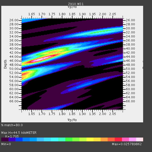
| Thickness Estimate: | 44 km |
| Thickness StdDev: | 6.1 km |
| Vp/Vs Estimate: | 1.71 |
| Vp/Vs StdDev: | 0.11 |
| Vs Estimate: | 3.85 km/s |
| Poisson's Ratio: | 0.24 |
| Peak Value: | 0.03 |
| Assumed Vp: | 6.565 km/s |
| Ps Weight: | 0.33333334 |
| PpPs Weight: | 0.33333334 |
| PsPs Weight: | 0.33333328 |
| Residual Complexity: | 0.673 |
| Nearby stations H: | +- |
| (2.0 deg) Vp/Vs: | +- |
6 with match > 90% ( 17.647058 %) and 7 with match > 80% ( 20.588236 %) out of 34.
Download stack as xyz text file.
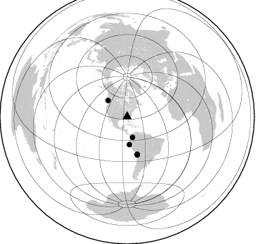
Azimuth Distribution of Events:
Prior Results for this Station
| Study | Thickness | Vp/Vs | Vp | Vs | Poissons Ratio | Extra |
| EARS | 44 km | 1.71 | 6.565 km/s | 3.85 km/s | 0.24 | |
| Crust2.0 | 31 km | 1.78 | 6.565 km/s | 3.684 km/s | 0.27 | DG,thin Platform 1 km seds. |
| Global Maxima | 44 km | 1.71 | 6.565 km/s | 3.85 km/s | 0.24 | amp=0.025789862 |
| Local Maxima 1 | 54 km | 1.60 | 6.565 km/s | 4.103 km/s | 0.18 | amp=0.01806677 |
| Local Maxima 2 | 41 km | 1.76 | 6.565 km/s | 3.725 km/s | 0.26 | amp=0.015172384 |
| Local Maxima 3 | 52 km | 1.60 | 6.565 km/s | 4.103 km/s | 0.18 | amp=0.012217287 |
| Local Maxima 4 | 32 km | 1.95 | 6.565 km/s | 3.362 km/s | 0.32 | amp=0.009643281 |
| Predicted Arrivals for vertical incidence (zero ray parameter) | |
| Ps | 4.78 SECOND |
| PpPs | 18.34 SECOND |
| PsPs/PpSs | 23.12 SECOND |
Events Processed for this Station
Download zip of receiver functions as SAC
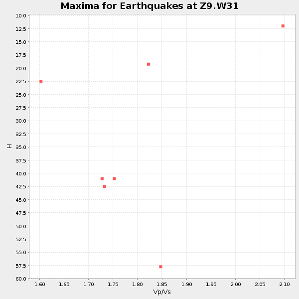
Plot maxima for each earthquake.
Events Used in the Stack
(7 events)| Radial Match | Distance | Baz | FERegion | Time | Lat/Lon | Depth | Magnitude |
| 96.65819 | 35.6 deg | 309.838 deg | Vancouver Island, Canada Region | 2014/04/24 03:10:13 GMT | (49.8, -127.4) | 11 km | 6.7 MWP, 6.7 MI |
| 95.22313 | 55.0 deg | 164.904 deg | Near Coast Of Northern Chile | 2014/03/16 21:16:30 GMT | (-19.9, -70.6) | 20 km | 6.7 MWW, 6.7 MWC, 7.0 MI |
| 94.15298 | 55.4 deg | 164.92 deg | Near Coast Of Northern Chile | 2014/04/03 01:58:31 GMT | (-20.3, -70.6) | 23 km | 6.5 MWW, 6.5 MWB, 6.6 MWC |
| 93.692986 | 39.4 deg | 175.637 deg | Near Coast Of Northern Peru | 2014/03/15 23:51:33 GMT | (-5.6, -81.0) | 29 km | 6.3 MWW, 6.2 MWB, 6.3 MWC |
| 92.84834 | 55.7 deg | 165.22 deg | Near Coast Of Northern Chile | 2014/04/04 01:37:51 GMT | (-20.6, -70.7) | 20 km | 6.1 MWP, 6.1 MWB, 6.1 MWW, 6.3 MWC |
| 90.774506 | 54.8 deg | 165.135 deg | Near Coast Of Northern Chile | 2014/03/22 12:59:59 GMT | (-19.8, -70.9) | 20 km | 6.2 MWW, 6.2 MWB, 6.3 MWC, 6.4 MWC |
| 80.15028 | 30.0 deg | 165.746 deg | Colombia | 2014/01/05 03:36:40 GMT | (4.6, -76.6) | 54 km | 5.5 MWB, 5.6 MWC |
Losers
(27 events)| Radial Match | Distance | Baz | FERegion | Time | Lat/Lon | Depth | Magnitude | Reason |
| 98.45861 | 54.7 deg | 165.038 deg | Near Coast Of Northern Chile | 2014/04/01 23:46:46 GMT | (-19.6, -70.8) | 20 km | 8.2 MWW, 8.0 MI, 8.1 MWC | |
| 96.70928 | 55.9 deg | 164.89 deg | Near Coast Of Northern Chile | 2014/04/03 05:51:44 GMT | (-20.8, -70.4) | 27 km | 5.5 MB, 5.3 MWR | |
| 96.63853 | 55.6 deg | 164.925 deg | Near Coast Of Northern Chile | 2014/04/03 02:43:14 GMT | (-20.5, -70.5) | 31 km | 7.7 MWW, 7.4 MI, 7.7 MWC | |
| 95.7272 | 33.4 deg | 294.116 deg | Off Coast Of Northern California | 2014/03/10 05:18:13 GMT | (40.8, -125.1) | 17 km | 6.8 MW, 6.8 MWR, 6.9 MWW, 6.9 MWB, 7.0 MI, 7.0 MWC | |
| 79.726265 | 55.3 deg | 165.061 deg | Near Coast Of Northern Chile | 2014/04/02 00:33:45 GMT | (-20.2, -70.7) | 13 km | 5.5 MB | |
| 79.05697 | 54.7 deg | 332.653 deg | Northern Alaska | 2014/05/03 08:57:12 GMT | (67.6, -162.2) | 0.9 km | 5.5 MB | |
| 69.98649 | 48.3 deg | 170.329 deg | Near Coast Of Peru | 2014/03/15 08:59:21 GMT | (-14.1, -76.3) | 20 km | 6.1 MWW, 6.0 MWB, 6.2 MWC | |
| 69.73184 | 82.3 deg | 325.051 deg | Kuril Islands | 2014/01/24 20:46:01 GMT | (48.7, 155.3) | 64 km | 4.2 mb | |
| 69.581764 | 54.8 deg | 165.059 deg | Near Coast Of Northern Chile | 2014/03/23 18:20:03 GMT | (-19.7, -70.8) | 35 km | 6.0 MB, 6.2 MWB, 6.2 MWW, 6.3 MWC | |
| 68.78548 | 56.2 deg | 157.328 deg | Southern Bolivia | 2014/01/27 16:42:37 GMT | (-19.3, -63.9) | 600 km | 5.6 MWB | |
| 68.581154 | 48.5 deg | 169.436 deg | Near Coast Of Peru | 2014/02/18 23:35:58 GMT | (-14.2, -75.6) | 57 km | 6.0 MWB, 5.9 MWW, 5.9 MWC, 6.0 MWC | |
| 68.12807 | 79.4 deg | 50.945 deg | Greece | 2014/02/03 03:08:46 GMT | (38.3, 20.4) | 5.0 km | 6.0 MWW, 6.0 MWB, 6.1 MWC | |
| 68.007996 | 63.7 deg | 211.563 deg | Easter Island Region | 2014/02/14 07:44:15 GMT | (-23.0, -114.3) | 12 km | 5.6 MWW, 5.5 MWB, 5.6 MWC | |
| 67.143745 | 50.6 deg | 322.812 deg | Southern Alaska | 2014/05/10 14:16:08 GMT | (60.0, -152.2) | 96 km | 5.8 ML, 5.5 MI, 5.7 MWP | |
| 66.97379 | 54.7 deg | 164.264 deg | Near Coast Of Northern Chile | 2014/04/01 23:59:57 GMT | (-19.5, -70.2) | 22 km | 5.8 MB | |
| 66.679855 | 62.4 deg | 317.774 deg | Fox Islands, Aleutian Islands | 2014/02/26 21:13:40 GMT | (53.6, -171.8) | 265 km | 6.1 MWW, 5.9 MI, 5.9 ML, 6.1 MWC, 6.1 MWB, 6.2 MWC | |
| 61.88243 | 79.5 deg | 50.962 deg | Greece | 2014/01/26 13:55:42 GMT | (38.2, 20.5) | 8.0 km | 6.1 MWW, 6.1 MWB, 6.2 MWC | |
| 59.92899 | 54.8 deg | 332.756 deg | Northern Alaska | 2014/04/18 18:56:47 GMT | (67.7, -162.5) | 17 km | 5.7 MW | |
| 59.00719 | 93.4 deg | 330.294 deg | Eastern Sea Of Japan | 2014/01/11 03:56:48 GMT | (43.7, 139.2) | 230 km | 5.0 MW | |
| 57.14788 | 67.5 deg | 317.301 deg | Andreanof Islands, Aleutian Is. | 2014/01/16 07:33:09 GMT | (51.2, -179.2) | 27 km | 5.5 MWB, 5.2 ML, 5.5 ML, 5.6 MWC | |
| 54.398506 | 55.2 deg | 165.109 deg | Near Coast Of Northern Chile | 2014/03/17 05:24:07 GMT | (-20.1, -70.8) | 10 km | 4.6 mb | |
| 50.50505 | 35.6 deg | 299.232 deg | Off Coast Of Oregon | 2014/05/12 18:51:00 GMT | (43.7, -128.1) | 14 km | 5.5 MW | |
| 45.7378 | 55.5 deg | 165.411 deg | Near Coast Of Northern Chile | 2014/04/06 14:06:09 GMT | (-20.4, -71.0) | 20 km | 5.3 MW | |
| 43.47564 | 81.0 deg | 328.367 deg | Northwest Of Kuril Islands | 2014/03/12 18:18:40 GMT | (52.0, 153.2) | 418 km | 5.1 MW | |
| 39.48449 | 78.5 deg | 49.743 deg | Greece-Albania Border Region | 2014/05/12 00:54:32 GMT | (39.8, 20.3) | 15 km | 4.9 mb | |
| 36.333115 | 55.0 deg | 165.126 deg | Near Coast Of Northern Chile | 2014/05/05 22:52:23 GMT | (-19.9, -70.8) | 12 km | 4.9 Mww | |
| 33.085594 | 55.7 deg | 165.3 deg | Near Coast Of Northern Chile | 2014/01/04 00:11:48 GMT | (-20.7, -70.8) | 26 km | 5.7 MWW, 5.8 MWB, 5.8 MWC |

