You are here: Home > Network List > CD - China Digital Seismograph Network Stations List
> Station BJI Baijiatuan, Beijing, China > Earthquake Result Viewer
BJI Baijiatuan, Beijing, China - Earthquake Result Viewer
| Earthquake location: |
Afghanistan-Tajikistan Bord Reg. |
| Earthquake latitude/longitude: |
36.4/71.6 |
| Earthquake time(UTC): |
1993/09/18 (261) 05:02:27 GMT |
| Earthquake Depth: |
117 km |
| Earthquake Magnitude: |
6.1 MB, 6.4 UNKNOWN, 6.1 MW |
| Earthquake Catalog/Contributor: |
WHDF/NEIC |
|
| Network: |
CD China Digital Seismograph Network |
| Station: |
BJI Baijiatuan, Beijing, China |
| Lat/Lon: |
40.04 N/116.18 E |
| Elevation: |
43 m |
|
| Distance: |
34.9 deg |
| Az: |
70.169 deg |
| Baz: |
278.519 deg |
| Ray Param: |
0.07709811 |
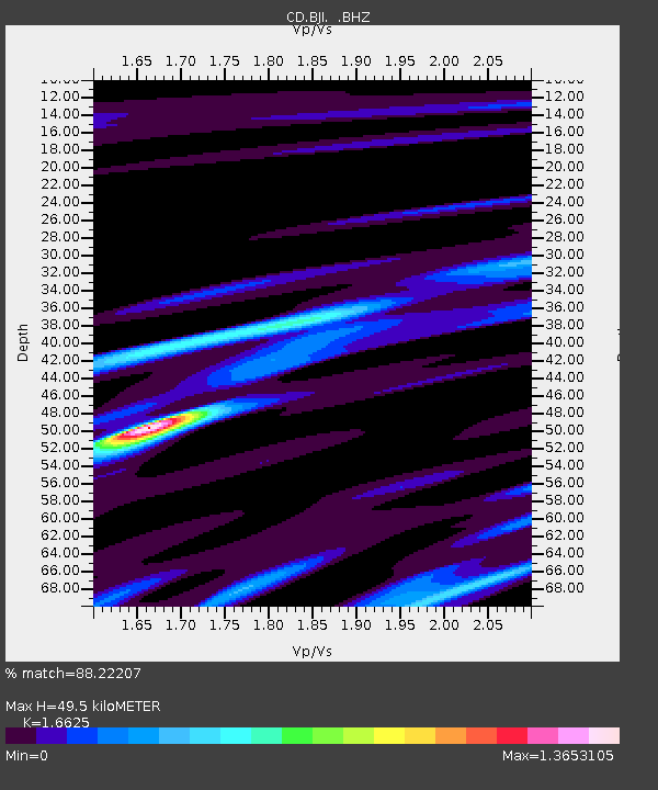
| Estimated Moho Depth: |
49.5 km |
| Estimated Crust Vp/Vs: |
1.66 |
| Assumed Crust Vp: |
6.464 km/s |
| Estimated Crust Vs: |
3.888 km/s |
| Estimated Crust Poisson's Ratio: |
0.22 |
|
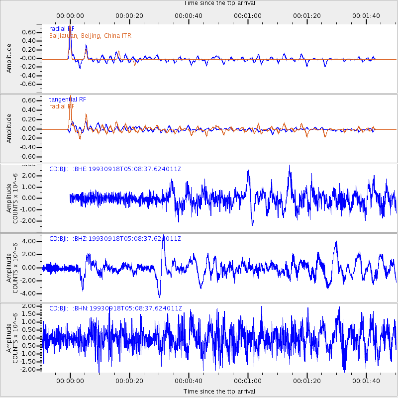
| Radial Match: |
88.22207 % |
| Radial Bump: |
331 |
| Transverse Match: |
77.44837 % |
| Transverse Bump: |
400 |
| SOD ConfigId: |
4480 |
| Insert Time: |
2010-02-26 21:18:39.186 +0000 |
| GWidth: |
2.5 |
| Max Bumps: |
400 |
| Tol: |
0.001 |
|
Signal To Noise
| Channel | StoN | STA | LTA |
| CD:BJI: :BHZ:19930918T05:08:37.624011Z | 3.6132936 | 1.0929904E-6 | 3.024914E-7 |
| CD:BJI: :BHN:19930918T05:08:37.624011Z | 0.97626644 | 4.077734E-7 | 4.1768658E-7 |
| CD:BJI: :BHE:19930918T05:08:37.624011Z | 1.9431363 | 6.061384E-7 | 3.1193818E-7 |
| Arrivals |
| Ps | 5.5 SECOND |
| PpPs | 19 SECOND |
| PsPs/PpSs | 24 SECOND |


