You are here: Home > Network List > TA - USArray Transportable Network (new EarthScope stations) Stations List
> Station W41A Tony Mavity, Velonia, AR, USA > Earthquake Result Viewer
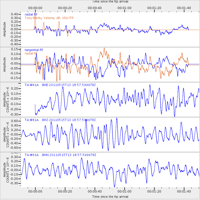
W41A Tony Mavity, Velonia, AR, USA - Earthquake Result Viewer
*The percent match for this event was below the threshold and hence no stack was calculated.
| Earthquake location: |
Central Mid-Atlantic Ridge |
| Earthquake latitude/longitude: |
0.6/-25.6 |
| Earthquake time(UTC): |
2011/05/15 (135) 13:08:13 GMT |
| Earthquake Depth: |
10 km |
| Earthquake Magnitude: |
5.6 MB, 5.4 MS, 6.1 MW, 6.1 MW |
| Earthquake Catalog/Contributor: |
WHDF/NEIC |
|
| Network: |
TA USArray Transportable Network (new EarthScope stations) |
| Station: |
W41A Tony Mavity, Velonia, AR, USA |
| Lat/Lon: |
35.17 N/92.25 W |
| Elevation: |
95 m |
|
| Distance: |
70.7 deg |
| Az: |
307.178 deg |
| Baz: |
103.46 deg |
| Ray Param: |
$rayparam |
*The percent match for this event was below the threshold and hence was not used in the summary stack. |
|
| Radial Match: |
51.703186 % |
| Radial Bump: |
400 |
| Transverse Match: |
42.44489 % |
| Transverse Bump: |
400 |
| SOD ConfigId: |
391883 |
| Insert Time: |
2011-10-22 23:51:55.834 +0000 |
| GWidth: |
2.5 |
| Max Bumps: |
400 |
| Tol: |
0.001 |
|
Signal To Noise
| Channel | StoN | STA | LTA |
| TA:W41A: :BHZ:20110515T13:18:57.599978Z | 0.9979843 | 1.7783059E-7 | 1.7818977E-7 |
| TA:W41A: :BHN:20110515T13:18:57.599978Z | 0.86899406 | 9.782186E-8 | 1.1256908E-7 |
| TA:W41A: :BHE:20110515T13:18:57.599978Z | 1.2227895 | 1.6245059E-7 | 1.3285245E-7 |
| Arrivals |
| Ps | |
| PpPs | |
| PsPs/PpSs | |


