You are here: Home > Network List > CD - China Digital Seismograph Network Stations List
> Station BJI Baijiatuan, Beijing, China > Earthquake Result Viewer
BJI Baijiatuan, Beijing, China - Earthquake Result Viewer
| Earthquake location: |
Northern Molucca Sea |
| Earthquake latitude/longitude: |
0.5/126.0 |
| Earthquake time(UTC): |
1993/12/09 (343) 04:32:22 GMT |
| Earthquake Depth: |
33 km |
| Earthquake Magnitude: |
6.3 MB, 6.7 MS, 6.7 UNKNOWN, 6.8 MW |
| Earthquake Catalog/Contributor: |
WHDF/NEIC |
|
| Network: |
CD China Digital Seismograph Network |
| Station: |
BJI Baijiatuan, Beijing, China |
| Lat/Lon: |
40.04 N/116.18 E |
| Elevation: |
43 m |
|
| Distance: |
40.4 deg |
| Az: |
348.355 deg |
| Baz: |
164.757 deg |
| Ray Param: |
0.07437422 |
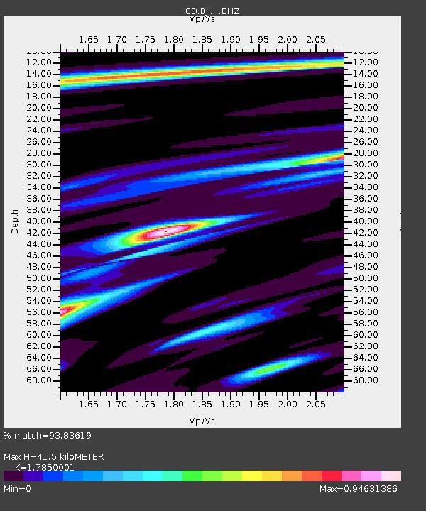
| Estimated Moho Depth: |
41.5 km |
| Estimated Crust Vp/Vs: |
1.79 |
| Assumed Crust Vp: |
6.464 km/s |
| Estimated Crust Vs: |
3.621 km/s |
| Estimated Crust Poisson's Ratio: |
0.27 |
|
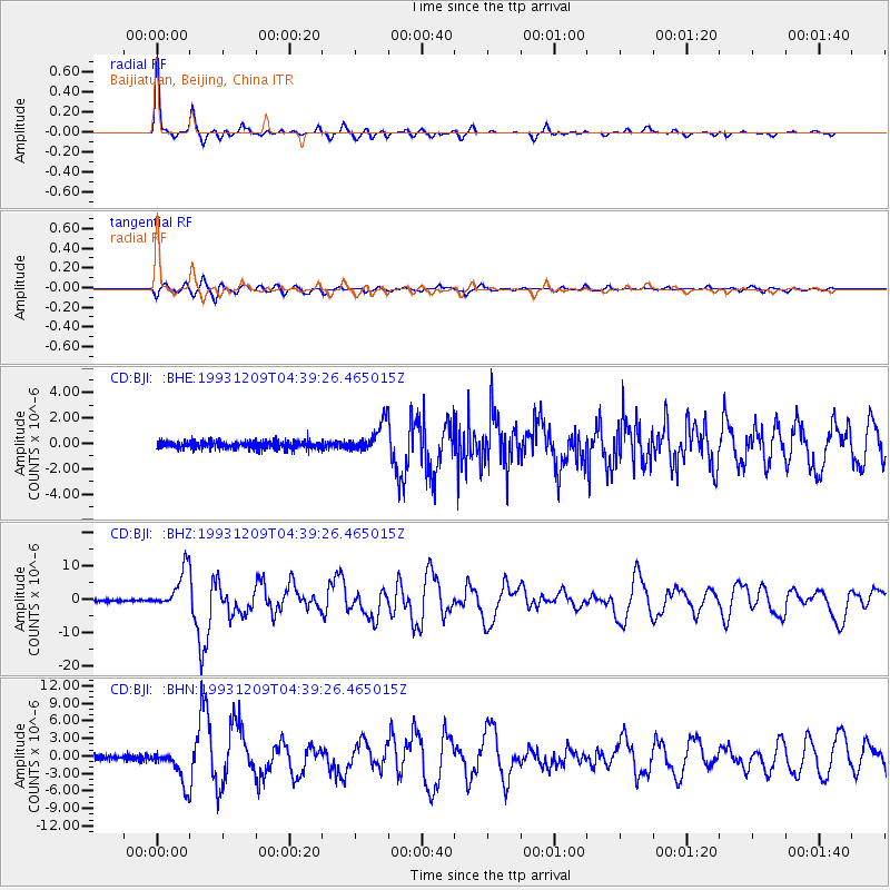
| Radial Match: |
93.83619 % |
| Radial Bump: |
287 |
| Transverse Match: |
77.914536 % |
| Transverse Bump: |
400 |
| SOD ConfigId: |
4480 |
| Insert Time: |
2010-02-26 21:19:08.267 +0000 |
| GWidth: |
2.5 |
| Max Bumps: |
400 |
| Tol: |
0.001 |
|
Signal To Noise
| Channel | StoN | STA | LTA |
| CD:BJI: :BHZ:19931209T04:39:26.465015Z | 25.920897 | 5.961685E-6 | 2.2999532E-7 |
| CD:BJI: :BHN:19931209T04:39:26.465015Z | 7.9466524 | 2.905439E-6 | 3.6561798E-7 |
| CD:BJI: :BHE:19931209T04:39:26.465015Z | 3.8762376 | 1.1420614E-6 | 2.946314E-7 |
| Arrivals |
| Ps | 5.4 SECOND |
| PpPs | 17 SECOND |
| PsPs/PpSs | 22 SECOND |


