You are here: Home > Network List > CD - China Digital Seismograph Network Stations List
> Station BJI Baijiatuan, Beijing, China > Earthquake Result Viewer
BJI Baijiatuan, Beijing, China - Earthquake Result Viewer
| Earthquake location: |
Northern Molucca Sea |
| Earthquake latitude/longitude: |
0.4/125.9 |
| Earthquake time(UTC): |
1993/12/09 (343) 11:38:30 GMT |
| Earthquake Depth: |
33 km |
| Earthquake Magnitude: |
6.1 MB, 6.4 MS, 6.3 UNKNOWN, 6.6 MW |
| Earthquake Catalog/Contributor: |
WHDF/NEIC |
|
| Network: |
CD China Digital Seismograph Network |
| Station: |
BJI Baijiatuan, Beijing, China |
| Lat/Lon: |
40.04 N/116.18 E |
| Elevation: |
43 m |
|
| Distance: |
40.4 deg |
| Az: |
348.472 deg |
| Baz: |
164.912 deg |
| Ray Param: |
0.07435469 |
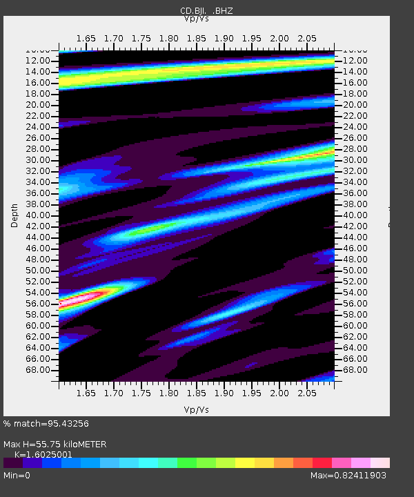
| Estimated Moho Depth: |
55.75 km |
| Estimated Crust Vp/Vs: |
1.60 |
| Assumed Crust Vp: |
6.464 km/s |
| Estimated Crust Vs: |
4.033 km/s |
| Estimated Crust Poisson's Ratio: |
0.18 |
|
| Radial Match: |
95.43256 % |
| Radial Bump: |
356 |
| Transverse Match: |
85.706635 % |
| Transverse Bump: |
400 |
| SOD ConfigId: |
4480 |
| Insert Time: |
2010-02-26 21:19:10.478 +0000 |
| GWidth: |
2.5 |
| Max Bumps: |
400 |
| Tol: |
0.001 |
|
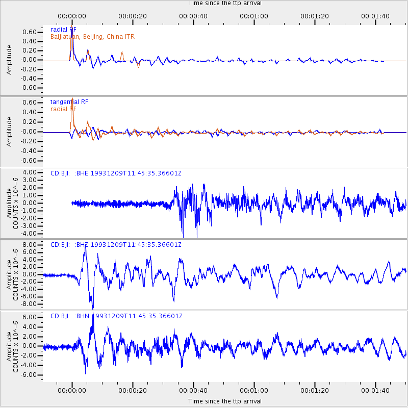
Signal To Noise
| Channel | StoN | STA | LTA |
| CD:BJI: :BHZ:19931209T11:45:35.36601Z | 20.001253 | 3.0097813E-6 | 1.5047962E-7 |
| CD:BJI: :BHN:19931209T11:45:35.36601Z | 5.4732137 | 1.5867465E-6 | 2.899113E-7 |
| CD:BJI: :BHE:19931209T11:45:35.36601Z | 3.0569606 | 6.4983266E-7 | 2.1257476E-7 |
| Arrivals |
| Ps | 5.6 SECOND |
| PpPs | 21 SECOND |
| PsPs/PpSs | 26 SECOND |


