You are here: Home > Network List > CD - China Digital Seismograph Network Stations List
> Station BJI Baijiatuan, Beijing, China > Earthquake Result Viewer
BJI Baijiatuan, Beijing, China - Earthquake Result Viewer
| Earthquake location: |
Tonga Islands |
| Earthquake latitude/longitude: |
-20.5/-173.8 |
| Earthquake time(UTC): |
1993/12/13 (347) 11:43:43 GMT |
| Earthquake Depth: |
33 km |
| Earthquake Magnitude: |
5.6 MB, 6.0 MS |
| Earthquake Catalog/Contributor: |
WHDF/NEIC |
|
| Network: |
CD China Digital Seismograph Network |
| Station: |
BJI Baijiatuan, Beijing, China |
| Lat/Lon: |
40.04 N/116.18 E |
| Elevation: |
43 m |
|
| Distance: |
88.8 deg |
| Az: |
313.79 deg |
| Baz: |
118.212 deg |
| Ray Param: |
0.04230923 |
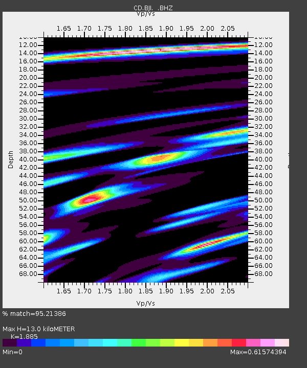
| Estimated Moho Depth: |
13.0 km |
| Estimated Crust Vp/Vs: |
1.88 |
| Assumed Crust Vp: |
6.464 km/s |
| Estimated Crust Vs: |
3.429 km/s |
| Estimated Crust Poisson's Ratio: |
0.30 |
|
| Radial Match: |
95.21386 % |
| Radial Bump: |
310 |
| Transverse Match: |
89.67218 % |
| Transverse Bump: |
400 |
| SOD ConfigId: |
4480 |
| Insert Time: |
2010-02-26 21:19:13.465 +0000 |
| GWidth: |
2.5 |
| Max Bumps: |
400 |
| Tol: |
0.001 |
|
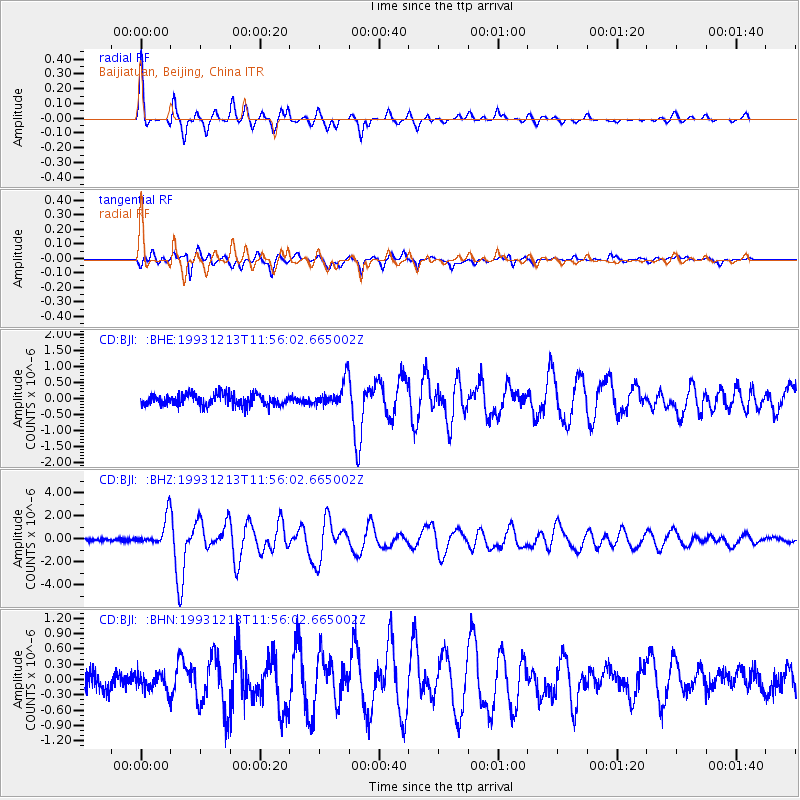
Signal To Noise
| Channel | StoN | STA | LTA |
| CD:BJI: :BHZ:19931213T11:56:02.665002Z | 9.417182 | 1.2900365E-6 | 1.3698752E-7 |
| CD:BJI: :BHN:19931213T11:56:02.665002Z | 1.0423065 | 1.7387131E-7 | 1.6681399E-7 |
| CD:BJI: :BHE:19931213T11:56:02.665002Z | 2.2477295 | 3.964008E-7 | 1.7635608E-7 |
| Arrivals |
| Ps | 1.8 SECOND |
| PpPs | 5.7 SECOND |
| PsPs/PpSs | 7.5 SECOND |


