You are here: Home > Network List > CD - China Digital Seismograph Network Stations List
> Station BJI Baijiatuan, Beijing, China > Earthquake Result Viewer
BJI Baijiatuan, Beijing, China - Earthquake Result Viewer
| Earthquake location: |
Irian Jaya, Indonesia |
| Earthquake latitude/longitude: |
-3.2/136.0 |
| Earthquake time(UTC): |
1994/01/19 (019) 01:53:36 GMT |
| Earthquake Depth: |
33 km |
| Earthquake Magnitude: |
6.0 MB, 6.9 MS, 6.9 UNKNOWN |
| Earthquake Catalog/Contributor: |
WHDF/NEIC |
|
| Network: |
CD China Digital Seismograph Network |
| Station: |
BJI Baijiatuan, Beijing, China |
| Lat/Lon: |
40.04 N/116.18 E |
| Elevation: |
43 m |
|
| Distance: |
46.7 deg |
| Az: |
339.025 deg |
| Baz: |
152.255 deg |
| Ray Param: |
0.070389286 |
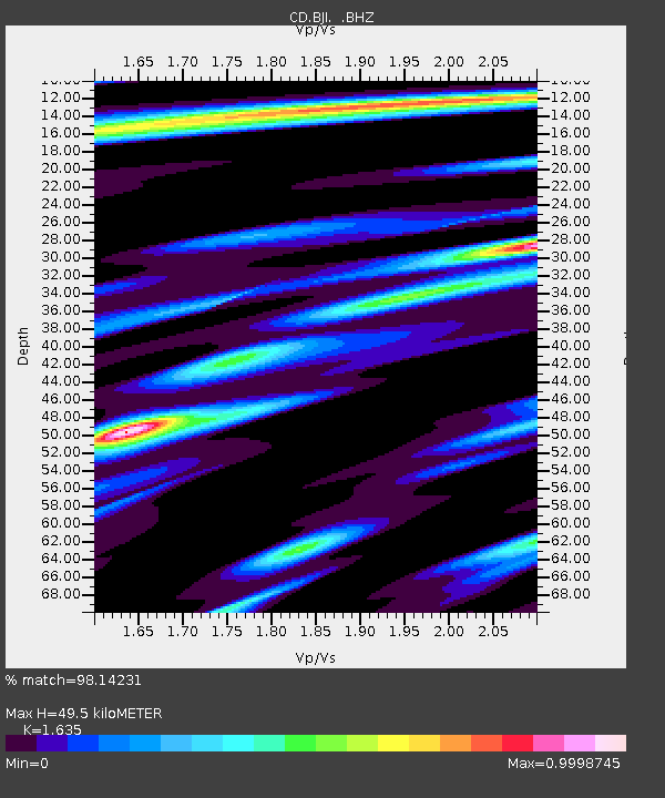
| Estimated Moho Depth: |
49.5 km |
| Estimated Crust Vp/Vs: |
1.63 |
| Assumed Crust Vp: |
6.464 km/s |
| Estimated Crust Vs: |
3.953 km/s |
| Estimated Crust Poisson's Ratio: |
0.20 |
|
| Radial Match: |
98.14231 % |
| Radial Bump: |
323 |
| Transverse Match: |
94.68743 % |
| Transverse Bump: |
400 |
| SOD ConfigId: |
4480 |
| Insert Time: |
2010-02-26 21:19:18.750 +0000 |
| GWidth: |
2.5 |
| Max Bumps: |
400 |
| Tol: |
0.001 |
|
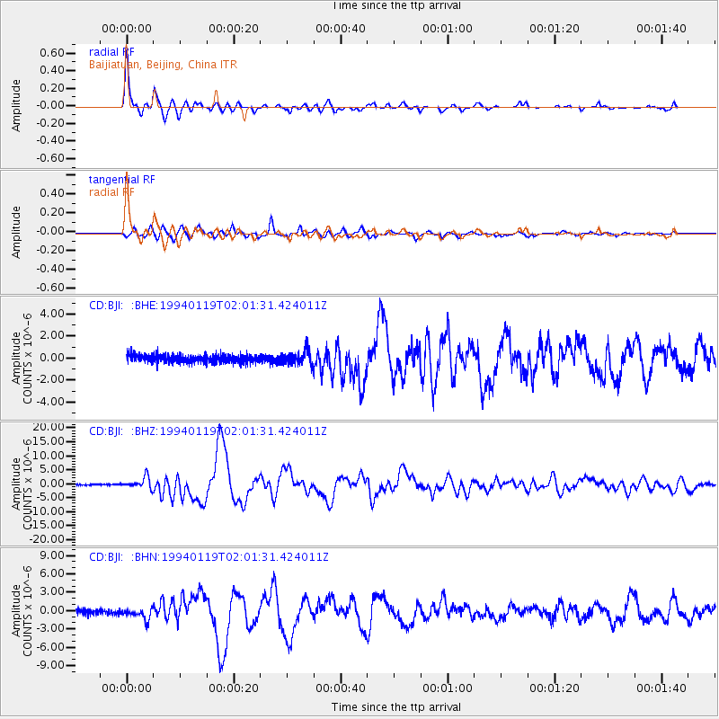
Signal To Noise
| Channel | StoN | STA | LTA |
| CD:BJI: :BHZ:19940119T02:01:31.424011Z | 10.829778 | 2.0973596E-6 | 1.9366598E-7 |
| CD:BJI: :BHN:19940119T02:01:31.424011Z | 2.6592107 | 9.015658E-7 | 3.3903513E-7 |
| CD:BJI: :BHE:19940119T02:01:31.424011Z | 1.761242 | 6.525381E-7 | 3.7049884E-7 |
| Arrivals |
| Ps | 5.2 SECOND |
| PpPs | 19 SECOND |
| PsPs/PpSs | 24 SECOND |


