You are here: Home > Network List > CD - China Digital Seismograph Network Stations List
> Station BJI Baijiatuan, Beijing, China > Earthquake Result Viewer
BJI Baijiatuan, Beijing, China - Earthquake Result Viewer
| Earthquake location: |
Halmahera, Indonesia |
| Earthquake latitude/longitude: |
1.0/127.7 |
| Earthquake time(UTC): |
1994/01/21 (021) 02:24:31 GMT |
| Earthquake Depth: |
33 km |
| Earthquake Magnitude: |
7.2 MS, 7.0 UNKNOWN |
| Earthquake Catalog/Contributor: |
WHDF/NEIC |
|
| Network: |
CD China Digital Seismograph Network |
| Station: |
BJI Baijiatuan, Beijing, China |
| Lat/Lon: |
40.04 N/116.18 E |
| Elevation: |
43 m |
|
| Distance: |
40.2 deg |
| Az: |
346.229 deg |
| Baz: |
161.94 deg |
| Ray Param: |
0.07444755 |
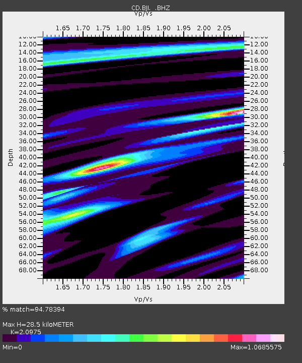
| Estimated Moho Depth: |
28.5 km |
| Estimated Crust Vp/Vs: |
2.10 |
| Assumed Crust Vp: |
6.464 km/s |
| Estimated Crust Vs: |
3.082 km/s |
| Estimated Crust Poisson's Ratio: |
0.35 |
|
| Radial Match: |
94.78394 % |
| Radial Bump: |
259 |
| Transverse Match: |
86.37982 % |
| Transverse Bump: |
400 |
| SOD ConfigId: |
4480 |
| Insert Time: |
2010-02-26 21:19:20.924 +0000 |
| GWidth: |
2.5 |
| Max Bumps: |
400 |
| Tol: |
0.001 |
|
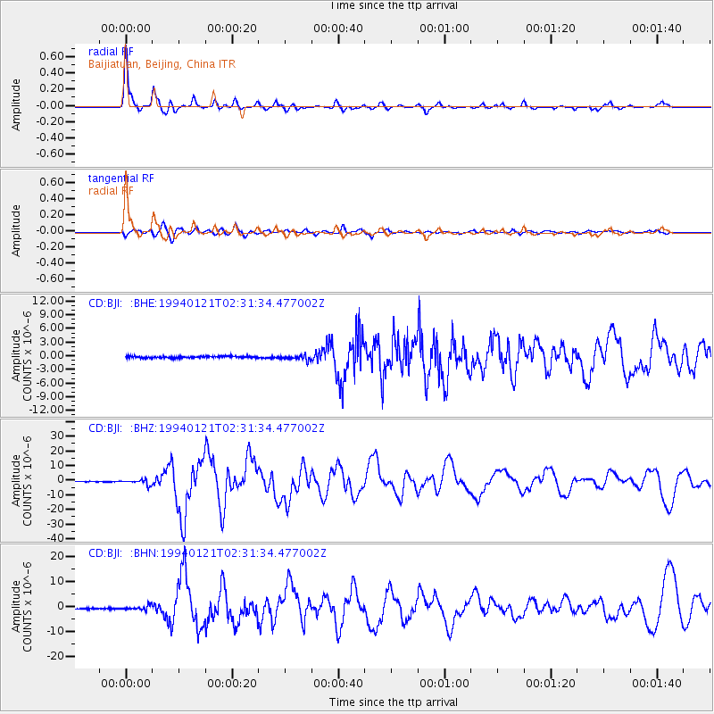
Signal To Noise
| Channel | StoN | STA | LTA |
| CD:BJI: :BHZ:19940121T02:31:34.477002Z | 8.8795395 | 1.8073958E-6 | 2.0354612E-7 |
| CD:BJI: :BHN:19940121T02:31:34.477002Z | 3.2414446 | 8.623752E-7 | 2.6604658E-7 |
| CD:BJI: :BHE:19940121T02:31:34.477002Z | 2.7275128 | 5.3221703E-7 | 1.9512906E-7 |
| Arrivals |
| Ps | 5.1 SECOND |
| PpPs | 13 SECOND |
| PsPs/PpSs | 18 SECOND |


