You are here: Home > Network List > CD - China Digital Seismograph Network Stations List
> Station BJI Baijiatuan, Beijing, China > Earthquake Result Viewer
BJI Baijiatuan, Beijing, China - Earthquake Result Viewer
| Earthquake location: |
Tonga Islands |
| Earthquake latitude/longitude: |
-17.4/-174.4 |
| Earthquake time(UTC): |
1994/02/24 (055) 15:25:35 GMT |
| Earthquake Depth: |
124 km |
| Earthquake Magnitude: |
5.6 MB |
| Earthquake Catalog/Contributor: |
WHDF/NEIC |
|
| Network: |
CD China Digital Seismograph Network |
| Station: |
BJI Baijiatuan, Beijing, China |
| Lat/Lon: |
40.04 N/116.18 E |
| Elevation: |
43 m |
|
| Distance: |
86.2 deg |
| Az: |
313.898 deg |
| Baz: |
116.318 deg |
| Ray Param: |
0.043984428 |
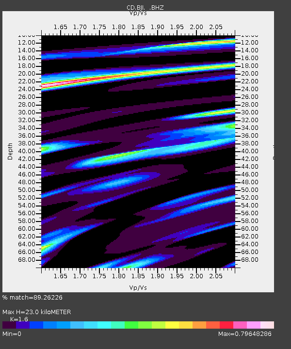
| Estimated Moho Depth: |
23.0 km |
| Estimated Crust Vp/Vs: |
1.60 |
| Assumed Crust Vp: |
6.464 km/s |
| Estimated Crust Vs: |
4.04 km/s |
| Estimated Crust Poisson's Ratio: |
0.18 |
|
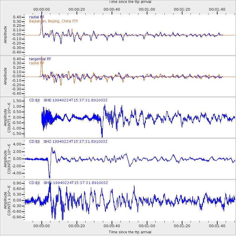
| Radial Match: |
89.26226 % |
| Radial Bump: |
348 |
| Transverse Match: |
82.79231 % |
| Transverse Bump: |
400 |
| SOD ConfigId: |
4480 |
| Insert Time: |
2010-02-26 21:19:35.825 +0000 |
| GWidth: |
2.5 |
| Max Bumps: |
400 |
| Tol: |
0.001 |
|
Signal To Noise
| Channel | StoN | STA | LTA |
| CD:BJI: :BHZ:19940224T15:37:31.891003Z | 7.787159 | 1.781318E-6 | 2.2875071E-7 |
| CD:BJI: :BHN:19940224T15:37:31.891003Z | 1.8936633 | 3.1512502E-7 | 1.6641027E-7 |
| CD:BJI: :BHE:19940224T15:37:31.891003Z | 1.8794663 | 5.570796E-7 | 2.9640307E-7 |
| Arrivals |
| Ps | 2.2 SECOND |
| PpPs | 9.0 SECOND |
| PsPs/PpSs | 11 SECOND |


