BJI Baijiatuan, Beijing, China - Earthquake Result Viewer
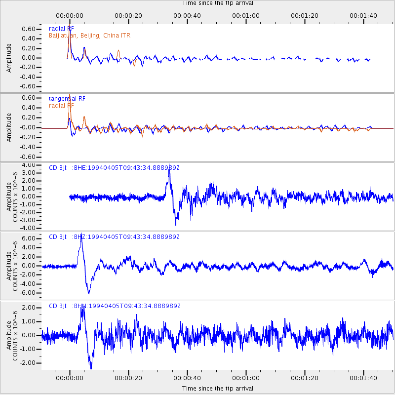
Earthquake location: Andreanof Islands, Aleutian Is.
Earthquake latitude/longitude: 51.3/-178.1
Earthquake time(UTC): 1994/04/05 (095) 09:35:46 GMT
Earthquake Depth: 33 km
Earthquake Magnitude: 5.8 MB, 5.9 MS, 6.2 UNKNOWN, 6.0 MW
Earthquake Catalog/Contributor: WHDF/NEIC
Network: CD China Digital Seismograph Network
Station: BJI Baijiatuan, Beijing, China
Lat/Lon: 40.04 N/116.18 E
Elevation: 43 m
Distance: 45.8 deg
Az: 282.596 deg
Baz: 52.941 deg
Ray Param: 0.07097377
Estimated Moho Depth: 52.5 km
Estimated Crust Vp/Vs: 1.60
Assumed Crust Vp: 6.464 km/s
Estimated Crust Vs: 4.04 km/s
Estimated Crust Poisson's Ratio: 0.18
Radial Match: 92.96241 %
Radial Bump: 345
Transverse Match: 83.5819 %
Transverse Bump: 400
SOD ConfigId: 4480
Insert Time: 2010-02-26 21:19:41.049 +0000
GWidth: 2.5
Max Bumps: 400
Tol: 0.001

Signal To Noise

ChannelStoNSTALTA
CD:BJI: :BHZ:19940405T09:43:34.888989Z16.029942.7200879E-61.6968797E-7
CD:BJI: :BHN:19940405T09:43:34.888989Z3.5926548.5380873E-72.3765404E-7
CD:BJI: :BHE:19940405T09:43:34.888989Z5.97176841.3739559E-62.3007522E-7
Arrivals
Ps5.2 SECOND
PpPs20 SECOND
PsPs/PpSs25 SECOND