You are here: Home > Network List > IC - New China Digital Seismograph Network Stations List
> Station HIA Hailar, Neimenggu Province, China > Earthquake Result Viewer
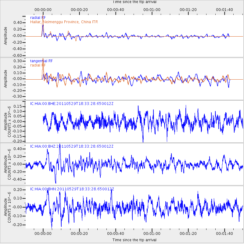
HIA Hailar, Neimenggu Province, China - Earthquake Result Viewer
*The percent match for this event was below the threshold and hence no stack was calculated.
| Earthquake location: |
Southwest Of Sumatra, Indonesia |
| Earthquake latitude/longitude: |
-7.7/101.8 |
| Earthquake time(UTC): |
2011/05/29 (149) 18:24:01 GMT |
| Earthquake Depth: |
13 km |
| Earthquake Magnitude: |
5.6 MB, 5.4 MS, 5.9 MW, 5.8 MW |
| Earthquake Catalog/Contributor: |
WHDF/NEIC |
|
| Network: |
IC New China Digital Seismograph Network |
| Station: |
HIA Hailar, Neimenggu Province, China |
| Lat/Lon: |
49.27 N/119.74 E |
| Elevation: |
620 m |
|
| Distance: |
58.9 deg |
| Az: |
13.663 deg |
| Baz: |
200.94 deg |
| Ray Param: |
$rayparam |
*The percent match for this event was below the threshold and hence was not used in the summary stack. |
|
| Radial Match: |
60.629524 % |
| Radial Bump: |
400 |
| Transverse Match: |
55.121925 % |
| Transverse Bump: |
400 |
| SOD ConfigId: |
393008 |
| Insert Time: |
2011-10-31 23:41:51.210 +0000 |
| GWidth: |
2.5 |
| Max Bumps: |
400 |
| Tol: |
0.001 |
|
Signal To Noise
| Channel | StoN | STA | LTA |
| IC:HIA:00:BHZ:20110529T18:33:28.650012Z | 2.527966 | 1.5885975E-7 | 6.284094E-8 |
| IC:HIA:00:BHN:20110529T18:33:28.650012Z | 2.6499827 | 1.0458611E-7 | 3.9466713E-8 |
| IC:HIA:00:BHE:20110529T18:33:28.650012Z | 0.8484847 | 4.1243123E-8 | 4.8607973E-8 |
| Arrivals |
| Ps | |
| PpPs | |
| PsPs/PpSs | |


