You are here: Home > Network List > CD - China Digital Seismograph Network Stations List
> Station HIA Hailar, Neimenggu Province, China > Earthquake Result Viewer
HIA Hailar, Neimenggu Province, China - Earthquake Result Viewer
| Earthquake location: |
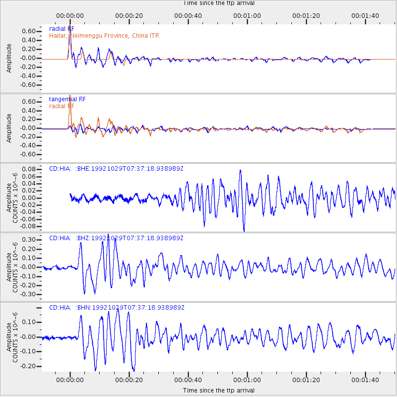
Mindanao, Philippines |
| Earthquake latitude/longitude: |
6.8/124.1 |
| Earthquake time(UTC): |
1992/10/29 (303) 07:29:57 GMT |
| Earthquake Depth: |
33 km |
| Earthquake Magnitude: |
5.5 MB, 5.9 MS |
| Earthquake Catalog/Contributor: |
WHDF/NEIC |
|
| Network: |
CD China Digital Seismograph Network |
| Station: |
HIA Hailar, Neimenggu Province, China |
| Lat/Lon: |
49.27 N/119.74 E |
| Elevation: |
610 m |
|
| Distance: |
42.5 deg |
| Az: |
355.81 deg |
| Baz: |
173.641 deg |
| Ray Param: |
0.07310253 |
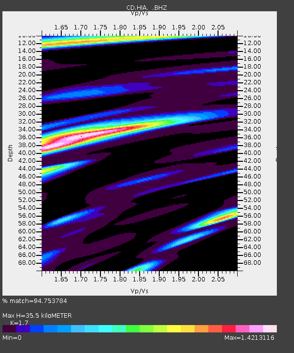
| Estimated Moho Depth: |
35.5 km |
| Estimated Crust Vp/Vs: |
1.70 |
| Assumed Crust Vp: |
6.577 km/s |
| Estimated Crust Vs: |
3.869 km/s |
| Estimated Crust Poisson's Ratio: |
0.24 |
|
| Radial Match: |
94.753784 % |
| Radial Bump: |
313 |
| Transverse Match: |
82.44502 % |
| Transverse Bump: |
400 |
| SOD ConfigId: |
4480 |
| Insert Time: |
2010-02-26 21:21:20.651 +0000 |
| GWidth: |
2.5 |
| Max Bumps: |
400 |
| Tol: |
0.001 |
|
Signal To Noise
| Channel | StoN | STA | LTA |
| CD:HIA: :BHZ:19921029T07:37:18.938989Z | 13.02857 | 1.1972946E-7 | 9.189762E-9 |
| CD:HIA: :BHN:19921029T07:37:18.938989Z | 7.592673 | 6.1725544E-8 | 8.12962E-9 |
| CD:HIA: :BHE:19921029T07:37:18.938989Z | 1.4820187 | 9.630302E-9 | 6.4980976E-9 |
| Arrivals |
| Ps | 4.1 SECOND |
| PpPs | 14 SECOND |
| PsPs/PpSs | 18 SECOND |


