
Station CD HIA - Hailar, Neimenggu Province, China
Network: CD - China Digital Seismograph Network
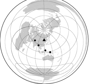
Nearby stations (2 deg radius)
| Station | Name | (Lat, Lon) | Start / End | Elevation |
| HIA | Hailar, Neimenggu Province, China | (49.27, 119.74) | 1986-07-20 / 1994-12-04 | 610 m |
| Crust2 Type: | Z2,Phanerozoic, 0.5 km seds. |
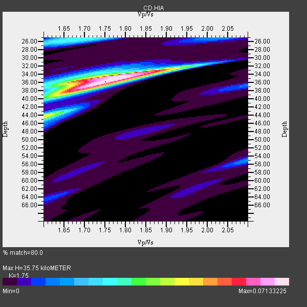
| Thickness Estimate: | 36 km |
| Thickness StdDev: | 1.2 km |
| Vp/Vs Estimate: | 1.75 |
| Vp/Vs StdDev: | 0.03 |
| Vs Estimate: | 3.758 km/s |
| Poisson's Ratio: | 0.26 |
| Peak Value: | 0.07 |
| Assumed Vp: | 6.577 km/s |
| Ps Weight: | 0.33333334 |
| PpPs Weight: | 0.33333334 |
| PsPs Weight: | 0.33333328 |
| Residual Complexity: | 0.534 |
| Nearby stations H: | 36 km +- 0.0 km |
| (2.0 deg) Vp/Vs: | 1.74 +- 0.01 |
2 with match > 90% ( 50.0 %) and 4 with match > 80% ( 100.0 %) out of 4.
Download stack as xyz text file.
Azimuth Distribution of Events:
Prior Results for this Station
| Study | Thickness | Vp/Vs | Vp | Vs | Poissons Ratio | Extra |
| EARS | 36 km | 1.75 | 6.577 km/s | 3.758 km/s | 0.26 | |
| Crust2.0 | 36 km | 1.78 | 6.577 km/s | 3.699 km/s | 0.27 | Z2,Phanerozoic, 0.5 km seds. |
| Zandt Ammon | 32 km | 1.82 | 6.0 km/s | 3.297 km/s | 0.28 | |
| Zandt Ammon | 34 km | 1.82 | 6.25 km/s | 3.434 km/s | 0.28 | |
| Zandt Ammon | 35 km | 1.81 | 6.5 km/s | 3.591 km/s | 0.28 | |
| Zandt Ammon | 37 km | 1.81 | 6.75 km/s | 3.729 km/s | 0.28 | |
| Global Maxima | 36 km | 1.75 | 6.577 km/s | 3.758 km/s | 0.26 | amp=0.07133225 |
| Local Maxima 1 | 36 km | 1.68 | 6.577 km/s | 3.909 km/s | 0.23 | amp=0.046164565 |
| Local Maxima 2 | 44 km | 1.60 | 6.577 km/s | 4.11 km/s | 0.18 | amp=0.03411305 |
| Local Maxima 3 | 33 km | 1.87 | 6.577 km/s | 3.517 km/s | 0.30 | amp=0.028536089 |
| Local Maxima 4 | 26 km | 1.67 | 6.577 km/s | 3.944 km/s | 0.22 | amp=0.027230473 |
| Predicted Arrivals for vertical incidence (zero ray parameter) | |
| Ps | 4.08 SECOND |
| PpPs | 14.95 SECOND |
| PsPs/PpSs | 19.03 SECOND |
Events Processed for this Station
Download zip of receiver functions as SAC
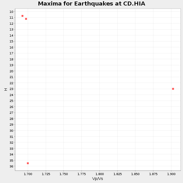
Plot maxima for each earthquake.
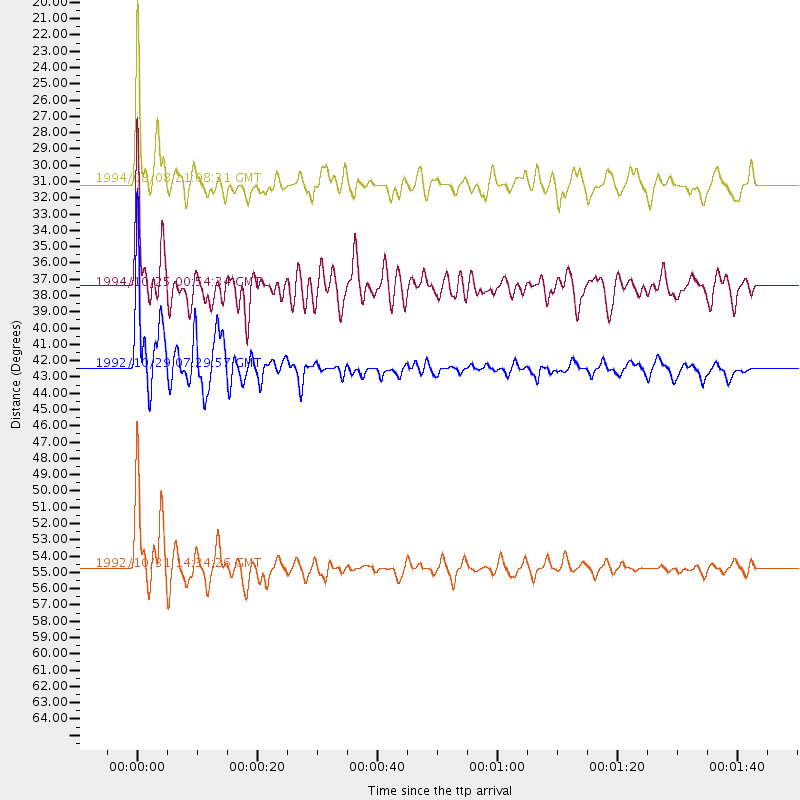
Events Used in the Stack
(4 events)| Radial Match | Distance | Baz | FERegion | Time | Lat/Lon | Depth | Magnitude |
| 94.753784 | 42.5 deg | 173.641 deg | Mindanao, Philippines | 1992/10/29 07:29:57 GMT | (6.8, 124.1) | 33 km | 5.5 MB, 5.9 MS |
| 94.12047 | 54.7 deg | 153.367 deg | Near N Coast Of New Guinea, P.N.G. | 1992/10/31 14:34:26 GMT | (-2.4, 141.2) | 33 km | 5.8 MB, 6.4 MS |
| 84.384514 | 37.5 deg | 268.518 deg | Hindu Kush Region, Afghanistan | 1994/10/25 00:54:34 GMT | (36.3, 70.9) | 244 km | 5.9 MB, 6.2 UNKNOWN, 5.9 MW |
| 83.710495 | 31.1 deg | 226.931 deg | Myanmar | 1994/08/08 21:08:31 GMT | (24.7, 95.2) | 127 km | 6.0 MB, 5.1 UNKNOWN, 6.1 MW |
Losers
(0 events)| Radial Match | Distance | Baz | FERegion | Time | Lat/Lon | Depth | Magnitude | Reason |
