You are here: Home > Network List > CD - China Digital Seismograph Network Stations List
> Station HIA Hailar, Neimenggu Province, China > Earthquake Result Viewer
HIA Hailar, Neimenggu Province, China - Earthquake Result Viewer

| Earthquake location: |
Near N Coast Of New Guinea, P.N.G. |
| Earthquake latitude/longitude: |
-2.4/141.2 |
| Earthquake time(UTC): |
1992/10/31 (305) 14:34:26 GMT |
| Earthquake Depth: |
33 km |
| Earthquake Magnitude: |
5.8 MB, 6.4 MS |
| Earthquake Catalog/Contributor: |
WHDF/NEIC |
|
| Network: |
CD China Digital Seismograph Network |
| Station: |
HIA Hailar, Neimenggu Province, China |
| Lat/Lon: |
49.27 N/119.74 E |
| Elevation: |
610 m |
|
| Distance: |
54.7 deg |
| Az: |
342.909 deg |
| Baz: |
153.367 deg |
| Ray Param: |
0.06521889 |
| Estimated Moho Depth: |
10.75 km |
| Estimated Crust Vp/Vs: |
1.69 |
| Assumed Crust Vp: |
6.577 km/s |
| Estimated Crust Vs: |
3.886 km/s |
| Estimated Crust Poisson's Ratio: |
0.23 |
|
| Radial Match: |
94.12047 % |
| Radial Bump: |
365 |
| Transverse Match: |
80.03412 % |
| Transverse Bump: |
400 |
| SOD ConfigId: |
4480 |
| Insert Time: |
2010-02-26 21:21:21.794 +0000 |
| GWidth: |
2.5 |
| Max Bumps: |
400 |
| Tol: |
0.001 |
|
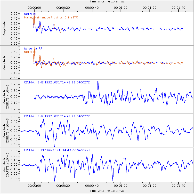
Signal To Noise
| Channel | StoN | STA | LTA |
| CD:HIA: :BHZ:19921031T14:43:22.040027Z | 7.88762 | 1.0707496E-7 | 1.35750655E-8 |
| CD:HIA: :BHN:19921031T14:43:22.040027Z | 4.5705314 | 5.280344E-8 | 1.155302E-8 |
| CD:HIA: :BHE:19921031T14:43:22.040027Z | 1.7332829 | 2.5762105E-8 | 1.4863185E-8 |
| Arrivals |
| Ps | 1.2 SECOND |
| PpPs | 4.2 SECOND |
| PsPs/PpSs | 5.4 SECOND |


