You are here: Home > Network List > CD - China Digital Seismograph Network Stations List
> Station HIA Hailar, Neimenggu Province, China > Earthquake Result Viewer
HIA Hailar, Neimenggu Province, China - Earthquake Result Viewer
| Earthquake location: |
Myanmar |
| Earthquake latitude/longitude: |
24.7/95.2 |
| Earthquake time(UTC): |
1994/08/08 (220) 21:08:31 GMT |
| Earthquake Depth: |
127 km |
| Earthquake Magnitude: |
6.0 MB, 5.1 UNKNOWN, 6.1 MW |
| Earthquake Catalog/Contributor: |
WHDF/NEIC |
|
| Network: |
CD China Digital Seismograph Network |
| Station: |
HIA Hailar, Neimenggu Province, China |
| Lat/Lon: |
49.27 N/119.74 E |
| Elevation: |
610 m |
|
| Distance: |
31.1 deg |
| Az: |
31.748 deg |
| Baz: |
226.931 deg |
| Ray Param: |
0.07886414 |
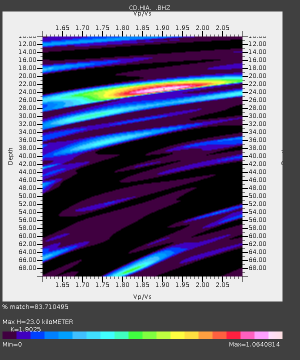
| Estimated Moho Depth: |
23.0 km |
| Estimated Crust Vp/Vs: |
1.90 |
| Assumed Crust Vp: |
6.577 km/s |
| Estimated Crust Vs: |
3.457 km/s |
| Estimated Crust Poisson's Ratio: |
0.31 |
|
| Radial Match: |
83.710495 % |
| Radial Bump: |
397 |
| Transverse Match: |
63.433155 % |
| Transverse Bump: |
400 |
| SOD ConfigId: |
4480 |
| Insert Time: |
2010-02-26 21:21:26.698 +0000 |
| GWidth: |
2.5 |
| Max Bumps: |
400 |
| Tol: |
0.001 |
|

Signal To Noise
| Channel | StoN | STA | LTA |
| CD:HIA: :BHZ:19940808T21:14:08.100012Z | 1.8558437 | 3.4012732E-8 | 1.832737E-8 |
| CD:HIA: :BHN:19940808T21:14:08.100012Z | 1.2559117 | 1.6699104E-8 | 1.32963995E-8 |
| CD:HIA: :BHE:19940808T21:14:08.100012Z | 1.491316 | 1.6329698E-8 | 1.0949858E-8 |
| Arrivals |
| Ps | 3.4 SECOND |
| PpPs | 9.4 SECOND |
| PsPs/PpSs | 13 SECOND |


