You are here: Home > Network List > TA - USArray Transportable Network (new EarthScope stations) Stations List
> Station W41A Tony Mavity, Velonia, AR, USA > Earthquake Result Viewer
W41A Tony Mavity, Velonia, AR, USA - Earthquake Result Viewer
| Earthquake location: |
Near Coast Of Central Chile |
| Earthquake latitude/longitude: |
-37.6/-73.7 |
| Earthquake time(UTC): |
2011/06/01 (152) 12:55:22 GMT |
| Earthquake Depth: |
21 km |
| Earthquake Magnitude: |
5.6 MB, 6.2 MS, 6.3 MW, 6.3 MW |
| Earthquake Catalog/Contributor: |
WHDF/NEIC |
|
| Network: |
TA USArray Transportable Network (new EarthScope stations) |
| Station: |
W41A Tony Mavity, Velonia, AR, USA |
| Lat/Lon: |
35.17 N/92.25 W |
| Elevation: |
95 m |
|
| Distance: |
74.4 deg |
| Az: |
344.296 deg |
| Baz: |
164.781 deg |
| Ray Param: |
0.052332055 |
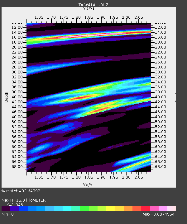
| Estimated Moho Depth: |
15.0 km |
| Estimated Crust Vp/Vs: |
1.85 |
| Assumed Crust Vp: |
6.498 km/s |
| Estimated Crust Vs: |
3.522 km/s |
| Estimated Crust Poisson's Ratio: |
0.29 |
|
| Radial Match: |
93.64392 % |
| Radial Bump: |
327 |
| Transverse Match: |
78.185776 % |
| Transverse Bump: |
400 |
| SOD ConfigId: |
393008 |
| Insert Time: |
2011-11-01 00:17:40.550 +0000 |
| GWidth: |
2.5 |
| Max Bumps: |
400 |
| Tol: |
0.001 |
|

Signal To Noise
| Channel | StoN | STA | LTA |
| TA:W41A: :BHZ:20110601T13:06:27.450007Z | 2.8218641 | 2.8015972E-7 | 9.92818E-8 |
| TA:W41A: :BHN:20110601T13:06:27.450007Z | 1.4185418 | 1.5928225E-7 | 1.122859E-7 |
| TA:W41A: :BHE:20110601T13:06:27.450007Z | 1.2268432 | 8.775443E-8 | 7.152864E-8 |
| Arrivals |
| Ps | 2.0 SECOND |
| PpPs | 6.4 SECOND |
| PsPs/PpSs | 8.4 SECOND |


